By Ed Caryl
The climate calamitologists depend on a continuous calamity supply: high temperature records, the occasional flood, forest fires, tornadoes striking cities, and hurricanes wiping out coastal areas, preferably the heavily populated. Some tropical storm Sandy damage to Staten Island will probably remain un-repaired simply because it is proximate to New York City and all the media therein. It’s very handy for photo-ops and as background for TV climate docu-drama talking heads. As everyone seems to be making money from these copyrighted pictures, none are included here.
The current spate of stories about temperature records in the western U. S. is a case in point. These temperature “records” are all produced by locations that are designed to produce temperature records. The automated station at Bad Water in Death Valley is just one example. As John Daly pointed out, and Anthony Watts reiterated, the station is backed up against a western-facing cliff, right in front of a black-top highway and centered on the black-top parking area, with a white salt pan to the west to reflect the afternoon heat. Just go to Google Street View on the highway and spin the view around. The whole area looks like a giant boy-scout solar bake-oven. Sooner or later, this spot will produce a world record high temperature, which will be publicized across the world as proof of global warming/climate change/extreme weather, or whatever the buzz-phrase de jour.
Another example is Mercury, Nevada. You don’t suppose the name refers to the local summer temperature, do you? Both weather stations there are at the airport (of course). The station next the the asphalt is the one setting records (of course). One gets tired of pointing out that all weather stations at airports are surrounded by large expanses of tarmac (Black), and little else, except the occasional taxiing jet hairdryer-on-steroids. Both airports and aircraft have increased in size during this period of “global warming.” Could there possibly be a connection? I still await that article in the approved, peer-reviewed literature.
The loss of 19 firefighters in Arizona during a west coast heat wave was a gift from heaven for the Calamitologists. But please don’t notice that they died attempting to save homes built in a forest. These homes should not have been there, or at least should have been protected by firebreaks constructed before the fire and not during the fire as these brave men were attempting. Thirty years ago, this calamity would not have happened because the homes would not have been there.
Much has been made of natural disasters blamed on climate change. Few people point out that the opportunity for disaster has increased due to the growth of cites. Look at this picture of Texas from the ISS.
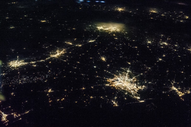
Source NASA, Public Domain. Texas at night from the International Space Station: Houston, lower right center; Dallas-Fort Worth, upper center; San Antonio, left center; Austin to the right of San Antonio; Port Arthur, lower right; Galveston, lower left.
Large parts of even the huge state of Texas are now covered by city. The odds of a tornado touching down in a populated area are increasing with the development of each suburb. That path of light from San Antonio to Dallas is Interstate Highway 35. Any tornado crossing that highway appears to have about a 50% chance of striking a populated area. Only a few years ago in that area, only beef cattle and the occasional oil rig were in danger. The recent storms that caused damage in the Oklahoma City area are also examples of tornadoes in areas where only 30 years ago there was only farmland. In “tornado alley” (the American plains states) with declining tornado activity, in spite of increased detection capability, (see here), (and more data here), the increasing size of cities is insuring a steady rise in urban damage, playing right into the hands of the Calamitologists.
None of the things described above have anything to do with climate and everything to do with population and infrastructure growth. But sooner or later the economic policies followed by the West will begin to limit growth. Any decrease in urban damage will be because there less urban value to damage. Weather will still do what it normally does.


Irradicate those who are responsible!.
Dr Baliunas on Weather Cooking
“calamitologist” is now in my lexicon.
Not sure how the author could get so many plain facts so wrong:
1) What is called Odessa/Midland is actually Austin, and Odessa/Midland would be off the map or in the far left
2) San Angelo would be off-image or in the far left
3) The path from San Antonio to Dallas I-35, not I-20
While the basic idea of the post is correct, about one-third to one-half of Texas is off the image, and most of what is left off is south and west Texas which is much less densly populated.
I stand corrected.
Now corrected.
Regarding building homes in a forest
and then defending them …
Use Google Earth and search for Plain, WA
(State of Washington, not Western Australia)
There are major housing developments at 3 kms both north and south of Plain. All around there are other smaller ones. Much land is National Forest and that limits further growth. The river flood plain is also occupied. Many places started as inexpensive winter/summer vacation spots but have morphed into full year occupancy.
There are a few “street view” routes in this section of Washington. Have a look from ground level. This a Ponderosa Pine area, quite dry with warm to hot summers.
Serious fires require bringing in crews and pumper trucks, some from surrounding States, and folks move into dangerous places to protect these houses. Water may be brought from major rivers or lakes many miles away to fill holding tanks for replenishing small trucks and helicopter buckets. That’s what is going on in the top right photo here:
http://199.134.225.50/nwcc/t1_pnw2/2004/pot-peak/digital-library/gallery-03.shtml
The thigh-high structure is a framed plastic pool filled with water. The Gallery 1 sequence includes a helicopter in flight (top left) and one picking up water (lower right). Gallery 4 has photos of filling from a lake.
All airplane fire fighting stopped by Obama admin?
With the planes used in fire fighting there are some issues but these problems did not start with the current Administration. Apparently not much is being done to solve either the age or size issue. The link below explains some of this:
http://beforeitsnews.com/environment/2013/05/as-massive-wildfires-sweep-california-where-is-the-biggest-fire-fighting-aircraft-2468478.html
Last fall there was a fire (The Taylor Bridge Fire) just to the west and the Columbia River is to our east. Planes flew directly over me as I was outside preparing for possible evacuation as the fire approached to about 8 kms. The planes skim the water and scoop up a load so they need a fairly long stretch of clear air space. The load and dump trip took them about 20 minutes. Our local airport is the central Washington heliport for the Department of Natural Resources (a State agency) and those craft can usually be sourced with water closer to the fire, but travel more slowly.
Thanks, John. I heard of some contracts not being renewed, that’s why I asked.