This morning major media outlets are warning that a major Atlantic storm (Xaver) is brewing East of the southern tip of Greenland.
The DWD has issued the following storm track with projected barometric pressure.
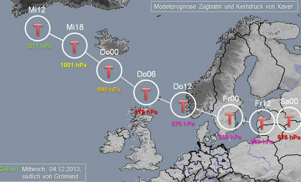
Mi = Wednesday, Do = Thursday, Fr = Friday and Sa = Saturday, T = Low. Source: DWD_presse/status/408119086887870465.
The pressure is expected to drop to 966 hPa by Thursday as Xaver crosses southern Norway and reaches Sweden. Wind speeds could reach 180 km/hour at some North Sea coastal areas. Cities like Hamburg, Bremen and Rostock could see winds of up to 140 km/hr. The back side of the storm is expected to pump Arctic air down over Germany and causing blizzard conditions and heavy snow.


LOOKS LIKE MORE GLOBAL WARMING ON THE WAY
Are there not a number of offshore windfarms in the Baltic sea???
Be interesting to see how the fare.
Don’t know about Baltic sea, but all around Denmark, and in the German North sea near Borkum, an island close to the Netherlands. Lots of off shore propellers. I’d say 10 % will break and a lot of repairs to be done next summer.
Do you think the damage will be reported in the news? Can the turbines take 2 days of 120 km/hr wind?
I don’t think there will be reports. The professional ethos of German journalists forbids them from reporting reality.
My estimate comes from what I saw after one heavy autumn storm 2 years ago in a windpark I travelled by every day; of course that’s rather circumstancial evidence. 2 out of 20 propellers stopped working after that storm.