In a new paper, data from 57 sites along 17 km of coastal Denmark reveal that sea levels were 11 to 12.5 meters higher than they are today between 7,600 and 4,600 years ago.
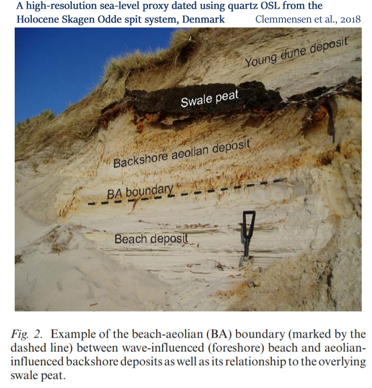
Image Source: Clemmensen et al., 2018
Most Holocene reconstructions do not indicate that sea levels were more than about 5 meters above present between about 9,000 to 4,000 years ago.
But a new study utilizing well-preserved beach facies along the coasts of northern Denmark indicates that sea levels were as much as 12.5 meters higher than they are today during the Mid-Holocene.
These extremely high sea level elevation values may be less common, but other research has revealed that sea levels were as much as 8 meters higher than today near East Antarctica (Hodgson et al., 2016) during the Early Holocene. Just 2,000 years ago, sea levels were still 12 meters higher than today along the coasts of King George Island (Antarctica) (Chu et al., 2017). And research published in 2011 suggested sea levels near the Antarctic Peninsula were as much as 15.5 meters higher than today between 8,000 and 7,000 years ago (Watcham et al., 2011).
This new research using high-resolution sea level proxy evidence can be added to the list of 75 other recently published sea level papers indicating that global sea levels were on average about 1 to 5 meters higher than they are now (depending on location) just a few thousand years ago.
Clemmensen et al., 2018
A high-resolution sea-level proxy dated using quartz OSL
from the Holocene Skagen Odde spit system, Denmark
Conclusion:
“The raised spit deposits at Skagen Odde, northern Denmark, offer a unique possibility to study spit evolution over the past 7600 years. The deposits contain well-preserved beach facies including the transition from wave-formed foreshore to aeolian-influenced backshore sediments. After correction foroffset and isostatic spatial gradient, we have been able to use this boundary as a proxy for palaeo-sea level.”
“Measurements at 57 sample sites covering ~17 km along the northwestern coast of the spit indicate that this boundary first rises towards the northeast, then reaches a maximum relative sea level at about 12.5 m above present mean sea level [apmsl] before gradually decreasing toward the most recent part of the spit.”
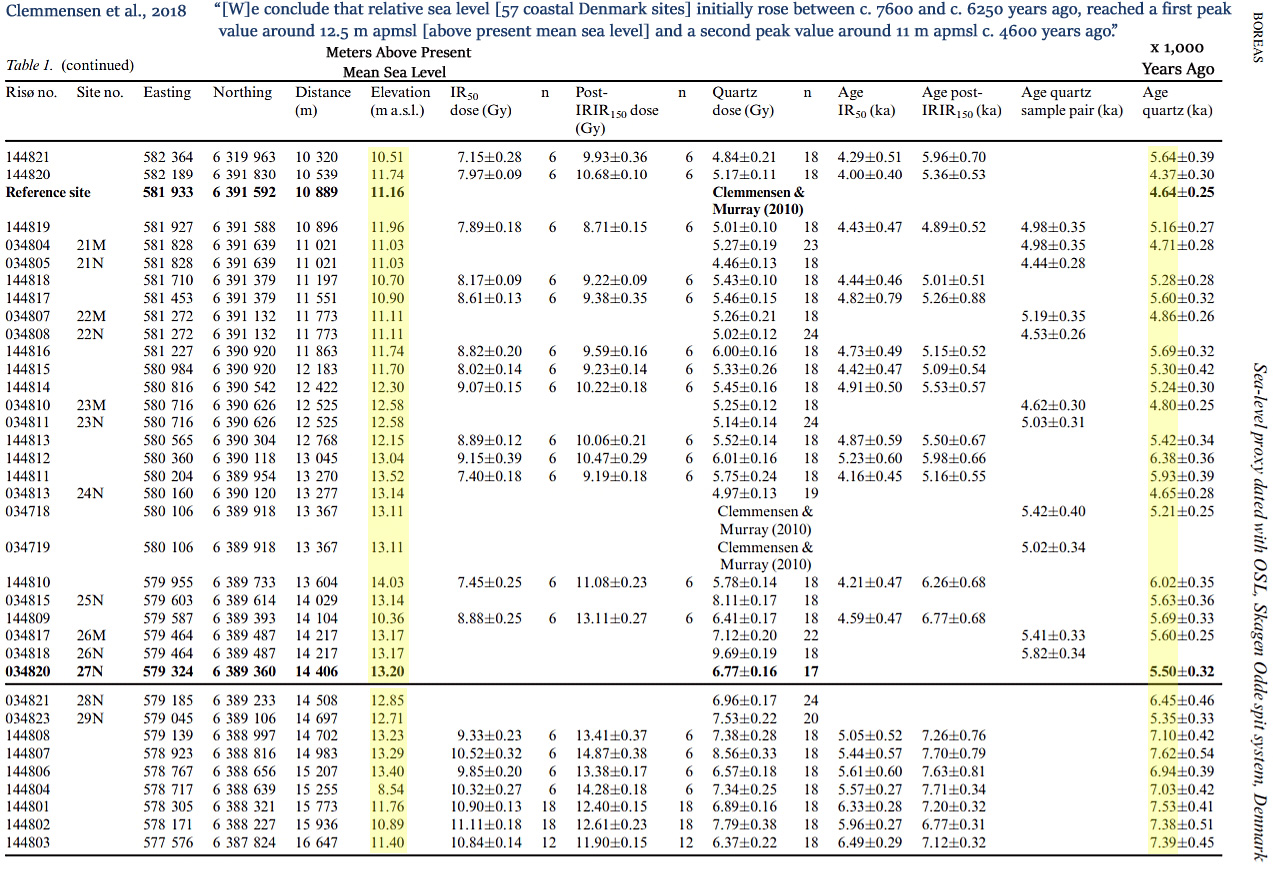
“By pairing all boundary elevation measurements with an OSL age, the variation in elevation with age has been determined directly. The resulting curve reflects variation in relative sea level with time; we conclude that relative sea level initially rose between c. 7600 and c. 6250 years ago, reached a first peak value around 12.5 m apmsl [above present mean sea level] and a second peak value around 11 m apmsl c. 4600 years ago before it dropped to reach 2 m apmsl c. 2000 years ago.”


Ancient ports are another indication that sea levels were higher than today (one of the reasons). For example
http://www.aoi.com.au/bcw/Sealevel/index.htm
http://www.ancientportsantiques.com/
Regards
Climate Heretic
What fascinating links, Climate Heretic. Even though I can’t find Ulysses maybe I can find his ports.
–
Australians have been more active than Americans testifying before their govt about the falsity of their “adjusted” temperature records, among other AGW lunancy. Hasn’t done ’em any good though.
I have stood on shallow water bars in Abu Dhabi 10 km from and 1.5 to 2.0m higher than the current gulf waters. Estabished geological work says 3,000 years ago the gulf was up to 17 km further inland.
Geological evidence is relevant today!
Sorry Mate. Scandinavia has raised several meters after the glacier of the ice age disappeared due to isostatic balance
That’s probably why sea levels are stable or continue to drop around Scandinavia today.
Finland:
https://notrickszone.com/wp-content/uploads/2017/06/Sea-Level-Falling-Finland-1.jpg
https://notrickszone.com/wp-content/uploads/2017/06/Sea-Level-Falling-Iceland-Finland.jpg
Denmark:
https://notrickszone.com/wp-content/uploads/2017/06/Sea-Level-Falling-Denmark-1.jpg
Norway:
https://notrickszone.com/wp-content/uploads/2017/06/Sea-Level-Falling-Norway-1.jpg
https://notrickszone.com/wp-content/uploads/2017/06/Sea-Level-Falling-Norway-2.jpg
https://notrickszone.com/wp-content/uploads/2017/06/Sea-Level-Falling-Norway-Kiribati.jpg
Sweden:
https://notrickszone.com/wp-content/uploads/2017/06/Sea-Level-Falling-Sweden.jpg
https://notrickszone.com/wp-content/uploads/2017/06/Sea-Level-Falling-Taiwan-Sweden.jpg
Isn’t the hinge line about Denmark with areas to the north still rising post glacial and those to the south still falling post glacial?
Yep, that 12m or so does seem rather excessive, and a significant part of it would be down to known and still occurring vertical land movement
There is a sort of tilting plate, iirc.
Stable geological areas mostly show sea level along coastlines as being 1-2m above current.
Neoglaciation, leading to the anomalous cold of the LIA locked up a LOT of ocean water as land ice.
The tiny natural warming since then, had barely made a pin-prick of difference. 2-3 mm/year of ocean rise along coast, and gradually slowing down.
That’s because the planet is so much COLDER than it was during that period.
Most of that is isostatic rebound. The hinge point is well south of Denmark. See: https://notrickszone.com/2014/05/05/data-show-holocene-sea-levels-trending-downwards-2-meters-higher-4000-and-8000-years-ago/#sthash.eoE1NpNG.dpbs
The sea level data in that article is from an area close to the Denmark/German border on North Sea.
At the ruins of Troy the sea is now a couple of kilometers away where it was at the walls of the city a few thousand years ago.