Rapid sea level rise was supposed
to shrink Earth’s coasts. It hasn’t.
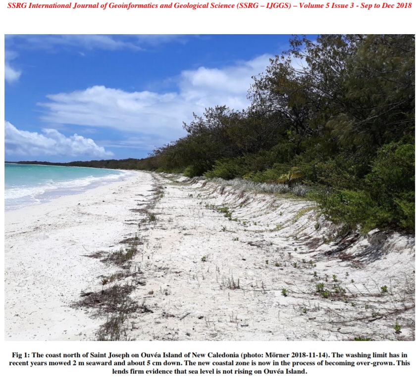
Image Source: Mörner, 2018
“Over the past decades, atoll islands exhibited no widespread sign of physical destabilization in the face of sea-level rise. 88.6% of islands were either stable or increased in area, while only 11.4% contracted. It is noteworthy that no island larger than 10 ha decreased in size. These results show that atoll and island areal stability is a global trend, whatever the rate of sea-level rise.”- Duvat, 2019
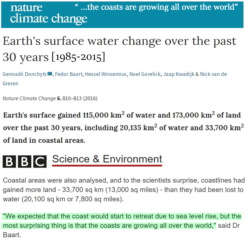
Image Sources: Donchyts et al., 2016 and BBC (press release)
I. Despite sea level rise, “the coasts are growing all over the world”
Sea levels aren’t rising fast enough to deleteriously affect coastal areas on a net global scale.
Satellite observations indicate there has been 13,565 km2 of net growth in land area across the globe’s coasts between 1985-2015.
In other words, the Earth’s coasts gained more land area than were lost to rising sea levels.
“Earth’s surface gained 115,000 km2 of water and 173,000 km2 of land over the past 30 years, including 20,135 km2 of water and 33,700 km2 of land in coastal areas.” (Donchyts et al., 2016)
As a visual example, Ahmed et al. (2018) find that Bangladesh’s coastal land area grew by 7.9 km2 per year during 1985-2015.
“This paper draws upon the application of GIS and remote sensing techniques to investigate the dynamic nature and management aspects of land in the coastal areas of Bangladesh. … This research reveals that the rate of accretion [coastal land growth] in the study area is slightly higher than the rate of erosion. Overall land dynamics indicate a net gain of 237 km2 (7.9 km2annual average) of land in the area for the whole period from 1985 to 2015.” (Ahmed et al., 2018)
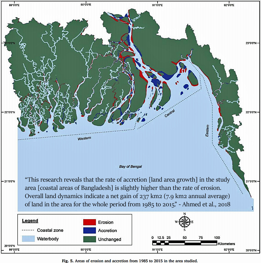
Image Source: Ahmed et al., 2018
II. Even with ~4 mm yr−1 local sea level rise, Pacific islands grew in size during 1971-2014
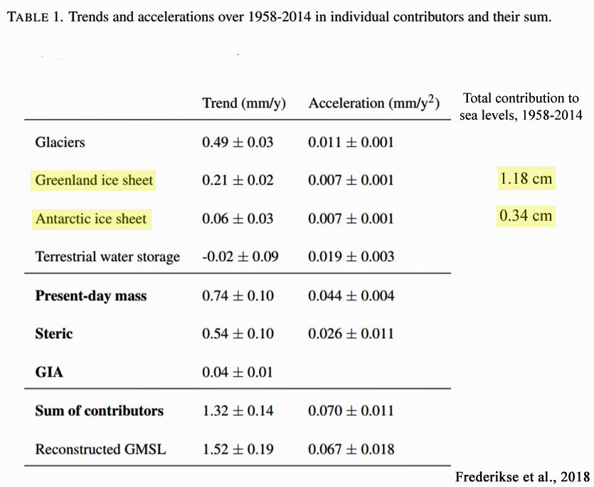
Between 1958-2014, the globe’s sea levels rose at a rate of about 1.4 mm yr−1 , or 14 centimeters (5.5 inches) per century (Frederikse et al., 2018).
Ice melt from Greenland and Antarctica contributed a grand total of 1.5 cm of the 7.9 cm (3.1 inches) of sea level rise during those 56 years.
“The global-mean sea level reconstruction shows a trend of 1.5 ± 0.2 mm yr−1 over 1958–2014 (1σ), compared to 1.3 ± 0.1 mm yr−1 for the sum of contributors.” (Frederikse et al., 2018)
However, there are regions of the world where sea levels are rising at rates two or three times the global average. Tuvalu, representing over 100 islands located in the central west Pacific, has undergone “twice the global average” rate of sea level rise (~3.90 ± 0.4 mm yr−1) since the 1970s.
It would be expected that such high rates of local sea level change would result in shrinking island coasts and overall land area during this period.
But the opposite has occurred. There has been a net increase in the coastal land area of Tuvalu between 1971-2014 in 8 of 9 atolls.
“We specifically examine spatial differences in island behaviour, of all 101 islands in Tuvalu, over the past four decades (1971–2014), a period in which local sea level has risen at twice the global average. Surprisingly, we show that all islands have changed and that the dominant mode of change has been island expansion, which has increased the land area of the nation.”
“Using remotely sensed data, change is analysed over the past four decades, a period when local sea level has risen at twice the global average (~3.90 ± 0.4 mm yr−1). Results highlight a net increase in land area in Tuvalu of 73.5 ha (2.9%), despite sea-level rise, and land area increase in eight of nine atolls.” (Kench et al., 2018)
III. The stability or coastal net growth of islands in recent decades to century “is a global trend”
Coastal stability and expansion for atoll and island land area is not just a regional trend, but a global one.
A comprehensive (709 islands) review of coastal changes that have been observed in the last decades to century (Duvat, 2019) reveals that no atoll island destabilization has occurred due to the effects of rising sea levels.
In fact, 88.6% of the globe’s islands have coasts that are either stable or expanding in size.
Further, not a single island larger than 10 hectares [1 ha = 10,000 square m, or 2.5 acres] has decreased in size in recent decades.
None of these observed trends affirm the popularized claim that modern sea level rise is currently threatening the globe’s coasts.
Duvat, 2019
A global assessment of atoll island
planform changes over the past decades
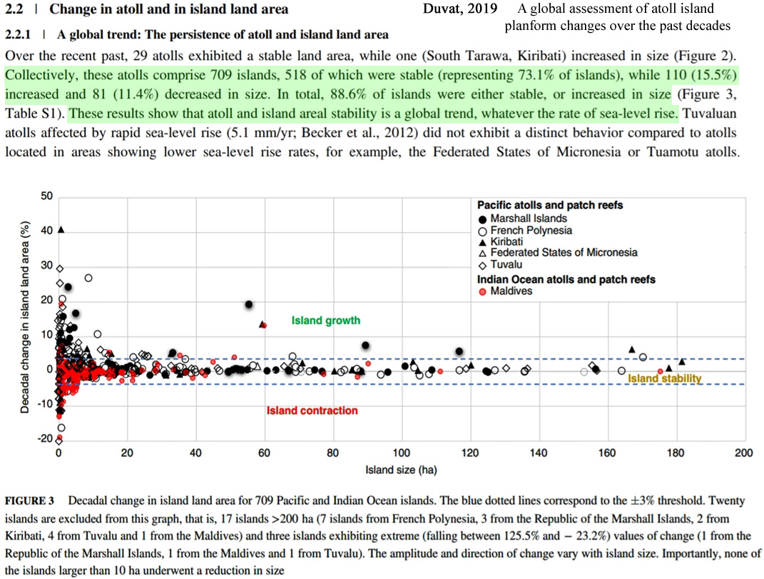
Image Source: Duvat, 2019
“This review first confirms that over the past decades to century, atoll islands exhibited no widespread sign of physical destabilization by sea level rise. The global sample considered in this paper, which includes 30 atolls and 709 islands, reveals that atolls did not lose land area, and that 73.1% of islands were stable in land area, including most settled islands, while 15.5% of islands increased and 11.4% decreased in size. Atoll and island areal stability can therefore be considered as a global trend.”
“Importantly, islands located in ocean regions affected by rapid sea-level rise showed neither contraction nor marked shoreline retreat, which indicates that they may not be affected yet by the presumably negative, that is, erosive, impact of sea-level rise.”
“It is noteworthy that no island larger than 10 ha decreased in size, making this value a relevant threshold to define atoll island areal stability.”
“[A]mong the 27 islands having a land area lying between 100 and 200 ha (9 in French Polynesia, 6 in the Marshall Islands, 6 in Kiribati, 5 in Tuvalu and 1 in the Federated States of Micronesia), only 3 increased in area, while 24 were stable.”
“The great majority of Pacific islands showed positional stability, as illustrated by the Tuamotu atolls, where 85–100% of islands were stable, depending on atolls (Duvat & Pillet, 2017; Duvat, Salvat, et al., 2017).”
“Importantly, the reanalysis of available data on atoll island planform change indicates that over the past decades to century, no island larger than 10 ha and only 4 out of the 334 islands larger than 5 ha (i.e., 1.2%) underwent a reduction in size.”
IV. Sea level rise is not the coastal threat that natural geological processes are
Rapid sea level rise rates due to global warming are not the threat to coastal communities and wildlife that they have often been claimed to be. What is? Natural geological/crustal changes, or vertical land movement.
Tied to the Earth’s gravitational attraction and shifting plates, geologic subsidence (land sinking) or uplift (land rising) processes are far more of a determinant of coastal structure and positioning than the rather small (by comparison) seawater volume changes in the world’s ocean basins. This is why sea level rise (or fall) rates are local, not global, as they vary quite dramatically across the world.
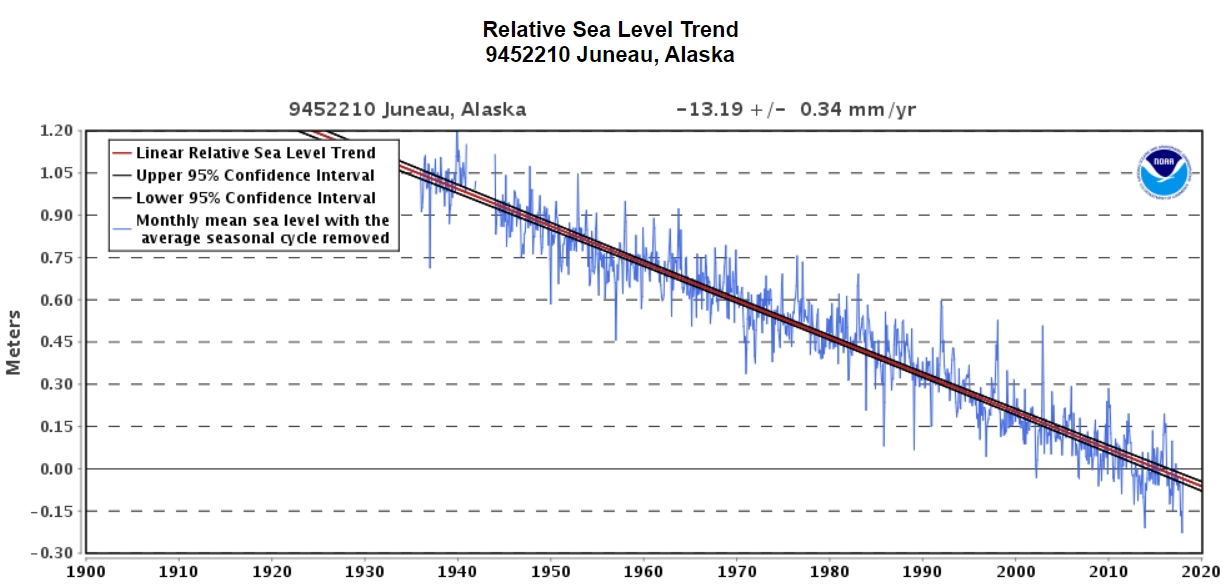
Along the coast of Juneau, Alaska, for example, the land surface has been rapidly rising due to gravitational uplift for many decades. Consequently, relative sea levels are plummeting in this region at a rate of over -13 mm yr−1 (minus-5 inches per decade) according to NOAA.
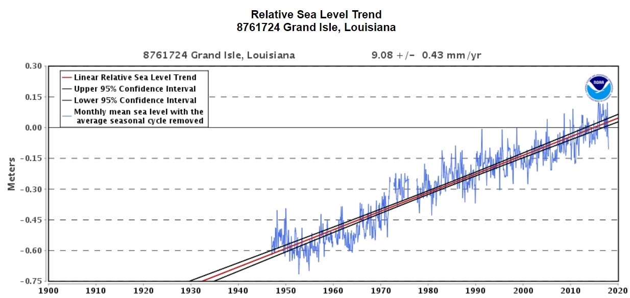
The opposite is occurring along the U.S. Gulf coast (Grand Isle, Louisiana), where the land area is sinking and thus sea levels are rising at a rate of over +9 mm yr−1.
Scientists have concluded that “sea level rise is not the primary factor controlling the shoreline changes” in regions where sea levels are rapidly rising (Testut et al., 2016). Even localized rates of sea level rise as high as 5 mm yr−1 are not rapid enough to overcome the much more pronounced geologic changes (accretion and uplift).
“We show that Grande Glorieuse Island has increased in area by 7.5 ha between 1989 and 2003, predominantly as a result of shoreline accretion [growth]: accretion occurred over 47% of shoreline length, whereas 26% was stable and 28% was eroded. Topographic transects and field observations show that the accretion is due to sediment transfer from the reef outer slopes to the reef flat and then to the beach. This accretion occurred in a context of sea level rise: sea level has risen by about 6 cm in the last twenty years and the island height is probably stable or very slowly subsiding. This island expansion during a period of rising sea level demonstrates that sea level rise is not the primary factor controlling the shoreline changes. This paper highlights the key role of non-climate factors in changes in island area, especially sediment availability and transport.” (Testut et al., 2016)
V. Vertical motions of the Earth’s crust exert “dominant control” over relative sea level
Along the eastern coast of the U.S., Piecuch and colleagues (2018) find that the “dominant control” over the disparate rates of sea level rise during the modern era has been exerted by “vertical motions of the Earth’s crust”, not climate.
“Here we analyse instrumental data and proxy reconstructions using probabilistic methods to show that vertical motions of Earth’s crust exerted the dominant control on regional spatial differences in relative sea-level trends along the US East Coast during 1900–2017, explaining most of the large-scale spatial variance. … Rates of coastal subsidence caused by ongoing relaxation of the peripheral forebulge associated with the last deglaciation are strongest near North Carolina, Maryland and Virginia [locations where the sea level rise rates are highest]. Our results indicate that the majority of large-scale spatial variation in long-term rates of relative sea-level rise on the US East Coast is due to geological processes that will persist at similar rates for centuries. … We note that negative VLM [vertical land motion] reflects subsidence and hence contributes to sea-level rise. Correspondingly, the most negative VLM [vertical land motion] rate (−2.5 ± 0.6 mm yr−1) is likely (P = 0.75) to occur in the states that host the maximum sea-level rise, North Carolina or Virginia, whereas the most positive rate of VLM (0.7 ± 0.8 mm yr−1) is very likely (P = 0.90) to occur in Maine.” (Piecuch et al., 2018)
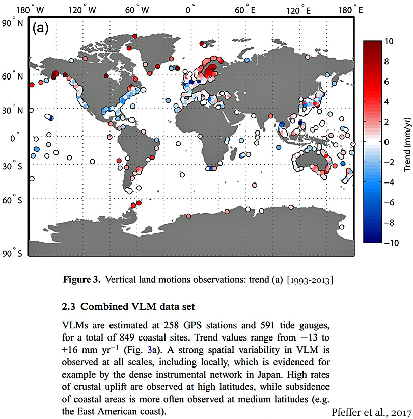
Pfeffer and colleagues (2017) assessed 849 coastal sites and determined that geophysical processes, or vertical land motion (VLM) trends (ranging from −13 to +16 mm yr−1 ), “have been recognized as a dominant component of the total relative sea-level variations observed at coasts” at locations throughout the globe.
“VLMs contribute actively to the sea-level changes felt by coastal populations, as they can amplify, diminish or counteract the effects of climate-induced signals (e.g. Pfeffer & Allemand 2016). In many cases, for example, Torres Islands (Ballu et al. 2011), western Tropical Pacific (Becker et al. 2012), southern Europe (Woppelmann & Marcos ¨ 2012) or Indian Ocean (Palanisamy et al. 2014), VLMs [vertical land motions] have been recognized as a dominant component of the total relative sea-level variations observed at coasts. … VLMs are estimated at 258 GPS stations and 591 tide gauges, for a total of 849 coastal sites. Trend values range from −13 to +16 mm yr−1 (Fig. 3a). A strong spatial variability in VLM is observed at all scales, including locally, which is evidenced for example by the dense instrumental network in Japan. High rates of crustal uplift are observed at high latitudes, while subsidence of coastal areas is more often observed at medium latitudes (e.g. the East American coast).” (Pfeffer et al., 2017)
VI. Meter-scale sea level rise is “related to geologic events only”, not climate change
In a 2018 paper published in the journal Geoscience Frontiers, geophysicist and tectonics expert Dr. Aftab Khan asserts that “both regional and local sea-level rise and fall in meter-scale is related to the geologic events only and not related to global warming and/or polar ice melt.”
Very high rates of land subsidence and uplift persist today. Vertical land motions as profound as ±10 to 30 mm yr−1 have been observed by geologists – easily overwhelming even the highest measured relative sea level changes.
The conclusion that rapid and high-amplitude (i.e., meters-per-century) sea level changes occur primarily as a consequence of natural geologic processes effectively leaves no room for global warming and/or polar ice melt to significantly contribute to the alarming meters-per-century sea level rise projected to engulf the Earth’s coasts by the end of the century.
Modeled predictions of multiple meters of sea level rise by 2100 (for example, 2.6 meters of global sea level rise by 2100 according to authors like Dr. Michael Mann and Dr. Richard Alley in Garner et al. 2017) are dismissed as “highly erroneous” by Dr. Khan.
Suggestions of a controlling anthropogenic influence on coastal and shoreline changes — the scariest aspect of climate modeling predictions — may therefore be significantly undermined by real-world scientific observations.


Can someone explain me how Earth’s surface can grow?
A river transports material towards the coasts. Some of the material doesn’t vanish into the oceans and thus grows the coastline (e.g. the surface grows). Another mechanism is caused by continental plates moving against each other. Cliffs can also erode into the ocean and form a larger in size coastline that before the erosion.
Seb,
Nice try.
So about those growing islands.
Seb, I remember some time ago you scoffed when I made the comment that all the sediment being deposited into the oceans displaces water and necessarily causes sea level to raise.
Please quantify then. Kenneth seems under the impression that uplift is what’s going on, so more land is “sticking” out of the oceans thus probably causing sea level to decline if nothing else was going on. Do you agree?
@Kurt: as with trash collecting on beaches, other material will acrete there as well when conditions are right.
I think it would be difficult to quantify sea level rise due to sedimentation. There are so many factors which affect the erosion rate. Plus the effects of uplift and subsidence. I think it is sufficient to understand logically it is a contributor to sea level variation. That it isn’t the sole domain of land based ice melt which affects the sea level!!! Or thermal expansion/contraction.
https://www.britannica.com/science/uplift
Thanks for the answers but I still feel confused.
I know the diameter of Earth the last decades grew a few decimeters due to sealevel rise but can that explain an 288.000 km2 total (land+water) surface gain?
Or do they mean land surface in 3D and not the projected surface on a 2D map.
The gain in water surface is a loss of land surface and the other way around. You should not add up those two figures.
If I can’t just add up the figures, I still can subtract them:
173.000 – 115.000= still 58.000 km2 netto (land)surface growth.
Uplift and subsidence are fundamental processes in Expansion Tectonics which predicts (requires) a continuous annual increase in the Earth’s radius. The process described in article above are entirely consistent with expansion tectonics and requires no ad hoc bolt on explanation.
There are plenty of books available on the subject (via Amazon) if you have an interest and are geologically inclined.
Thanks for answering.
…..which predicts (requires) a continuous annual increase in the Earth’s radius.
I was not aware of a continuous increase in Earth’s radius.
Do the Jason satellites take this into account?
Wiki says: “Although it was suggested historically, since the recognition of plate tectonics in the 1970s, scientific consensus has rejected any significant expansion or contraction of Earth.”
My simple question is sincere although probably I’m missing something obvious. I sincerly hope to get an answer.
The Earth’s surface collects millions of tons of space debris annually, anywhere from small grains to meteorite fragments. Certainly less that 0.00001% of the entire mass. Rotation has been slowing over millions of years and the orbit has changed, also. But considering the existence of life as we know it, it never happened.
Pfeffer et al., 2017
https://doi.org/10.1093/gji/ggx142
“In response to changes from the solar system to its deep interior, the surface of the Earth is constantly moving up and down (Fig. 1). Under the influence of tides, the land surface oscillates with an amplitude of a few tens centimetres per day (e.g. Tomaschek 1957). Vertical land motions (VLMs) arise in response to changes of mass distribution within the atmosphere, oceans and continents forced by natural or anthropogenic mechanisms (e.g. Mangiarotti et al. 2001). Since the last glacial maximum (LGM ≈ 21 000 yr ago), the solid Earth responds to the melt of the continental ice sheets and is still in a state of isostatic disequilibrium (e.g. King et al. 2010). The ongoing glacial isostatic adjustment (GIA) causes changes in the Earth’s rotation rate, gravity field, geocentre and shape. The vertical displacement of the Earth’s crust can exceed 10 mm yr−1 across previously glaciated areas (e.g. Sella et al. 2007; Milne et al. 2001). Driven by mantle convection, tectonic plates move at the Earth surface at the pace of a few centimetres per year.”
Willy, 18 January, 12.39.
I would not pay any attention to wiki in relation to Expansion Tectonics. There has been a small turf war at Wiki on this subject. Everything written there is from the plate tectonic perspective. Anything from an Expansion Tectonic perspective is quickly overwritten.
If you are interested you need to to do the searching independently for yourself.
Regarding satellite measurement: papers have been published supporting both sides of the argument. It is possible to select papers supporting either side of the arguments depending on your preferred bias.
It is a subject of ongoing interest, although it should be noted that NASA is strongly in the consensus camp of Plate Tectonics.
Why always point out the average sea level rise over a long timeperiod of accelerating rise? What is the current rate? What will be the rate in another 50 years if the acceleration continues as in those past 56 years?
Actually, Antarctica alone contributed 1.4 cm (+- 0.2 cm) from 1979 on until 2017:
https://www.pnas.org/content/early/2019/01/08/1812883116
And the mass loss there is accelerating as well:
40 Gt/y from 1979 to 1990, 50 Gt/y from 1989-2000, 166 Gt/y from 1999 to 2009 and 252 Gt/y from 2009 to 2017. All parts are losing ice mass.
As with all data series that show acceleration, looking at the past average change and imagining that the future won’t be too bad (e.g. similar to the past) is a bit strange.
What if the land movement has the opposite sign or no movement at all? Land is not rising at this rate everywhere since there are no melting glaciers everywhere (the reason for an uplift that high), right?
One can use the website Aqua Monitor (http://aqua-monitor.appspot.com/) to easily see where lang area is decreasing and increasing. There is a certain pattern to those changes. And don’t worry, it’s the official data that was gathered, not some “fake climate activist stuff” 😉
Glad that Dr. Kahn can do that. Since simply extrapolating the current acceleration to 2100 results in how many meters of sea level rise? That would indeed be unpleasent. Let’s hope thermal expansion and ice melt stabilize between now and then despite it doesn’t look like that will be the case from where what we know today.
That’s not the official prediction of the IPCC though, right? That’s for pretty special scenarios. With no further acceleration we are looking at a rise of more like 1 ft in 91 years.
This sounds smallish, but the thing is that the sea level that we speak of is kind of an average. We have tides, we have storm floods. Extreme events will be more devastating with a higher average. That’s a problem.
Trying to ignore thermal expansion and ice melt because “geological events” exist is a special kind of crazy. The same kind that makes you guys call more CO2 a good thing, I guess 😉
Good question. Here’s the answer from a sea level expert. Hint: if one starts at the bottom of a sine wave, one gets a positive acceleration. If one starts at the top of a sine wave, one gets a negative acceleration. Therefore, at least 80 to 100 years of data are needed to compute a rate and/or acceleration trend.
https://www.sciencedirect.com/science/article/pii/S0964569118303417
“At least 60 years of data collected by the same location without any perturbing event are needed to compute a reasonably accurate sea level rate of rise by linear fitting, and almost double that length, at least more than 100 years, are needed to compute a reasonably accurate sea level acceleration by parabolic fitting. In Japan, with its short time window, it may be wrongly concluded that the sea levels have been accelerating since the 1980s. By considering the data since 1906, as done by Japan Meteorological Agency (2018), or by considering the data since 1894 for Hosojima, Wajima, Aburatsubo and Tonoura, and since 1906 for Oshoro as done here, the sea levels are perfectly stable.”
“The relative sea level rise measured by a tide gauge has a sea and a land component. The relative sea level may rise, or fall, not only because the volume of the water is increasing, or reducing. It may also rise, or fall, because the tide gauge instrument is sinking, or uplifting. The sea component has important multi-decadal periodicities of quasi 60 years. Hence, not less than 60 years of data are needed to infer a rate of rise, and many more years, not less than 100 years, are needed to infer an acceleration. … Only where the land component is characterized by a stable pattern of subsidence or uplift, an absolute sea level rise can be computed. In Japan, only few areas are relatively stable, with the rest affected by crustal movements strongly variable in time and space.”
We don’t have that answer. We won’t know where we’ll be in the oscillation by then. During the 1925 to 1950 period, sea levels rose at a rate of between 2 to 4 mm yr. We even had a year — 1939 — when sea levels rose at a rate of 4.68 mm/yr.
Klige, 1990
http://link.springer.com/chapter/10.1007/978-94-009-0701-0_10#page-1
“During the recent century the rate of sea-level rise has reached 1.5 mm per year. The most intensive rise at a rate of more than 3 mm per year occurred from 1924 to 1948 (Fig. 2).”
After that abrupt rising period, the rate changed. During the 1925 to 1950 period, we didn’t know that the rates would slow from over 3 mm yr to 1 mm yr (or less) during the next 25-30 years. Likewise, we don’t know what the rate of rise will be 50 years from now. We can’t tell just by looking at short-term windows.
Considering the Southern Ocean surrounding Antarctica cooled during this period (Fan et al., 2014; Purich et al., 2018; Latif et al., 2017; Turney et al., 2017 ), what do you think the thermal mechanism was for this catastrophic 1.4 cm of meltwater equivalent?
The globe has cooled by -0.45°C in the last 3 years. That’s -1.5°C cooling per decade. That means that we can conclude that it’ll be -4.5°C colder than today in 2049. Right? Do you see that there could be a problem if we decide to cherry pick a starting point and then compute what the temperatures will be in the future? Or do you only have a problem when someone else grossly misuses data like I have here, but when you do it, it’s quite OK?
You’re doing it again: assuming that a cherry-picked short-term start-to-end point represents the “current” acceleration. An acceleration can only be determined by using at least 80-100 years of data due to sine wave and oscillatory sea level changes.
If we only use tide gauge data with greater than 80 years of measurement, the acceleration is about 0.002 mm yr.
https://link.springer.com/article/10.1007/s41748-017-0019-5
“[L]ocal sea-level forecasts should be based on proven local sea-level data. Their naïve averaging of all the tide gauges included in the PSMSL surveys showed ‘‘relative’’ trends of about + 1.04 mm/year (570 tide gauges of any length). By only considering the 100 tide gauges with more than 80 years of recording, the average trend was only + 0.25 mm/year [2.5 centimeters per century]. … The global sea-level acceleration is therefore in the order of + 0.002 ± 0.003 mm/year², i.e. + 2 ÷ 3 μm/year², well below the accuracy of the estimation. This means that the sea levels may rise in the twenty-first century only a few centimeters more than what they rose during the twentieth century.”
No one is “ignoring” thermal expansion and ice melt. We just have geologists and seismic experts report that the “dominant control” on sea level rise (and fall) rates is geologic activity/vertical land motion, as some regions have VLM of -10 to +30 mm yr, easily dwarfing a seawater volume change in the world ocean that may only add +1.5 cm of meltwater equivalent from the Greenland and Antarctic ice sheets combined over a 56-year period, or add the thermal expansion equivalent of about 0.65 mm yr. That’s just not enough to be deterministic relative to geological activity.
Since you believe that scientists who point out that geological activity plays a more deterministic role in relative sea level change than climate change does are “a special kind of crazy”, can you tell us how climate change explains why the sea levels are falling near Juneau at rates of -13 mm yr-1, then?
SebH isn’t interested in facts, only his preferred fantasies. The reason he never cites facts is because he hasn’t any, only unsupported assertions. His is a post-modern “science,” which, like all modern Leftist thought, is merely a collection of shared beliefs, asserted repeatedly against all evidence in hopes that they will “win” the argument by wearing out their opponents, not enlightening them with new fact based information.
Melanie Phillips has a good description of them here.
https://www.youtube.com/watch?v=ZkK7lgcLcSo&feature=youtu.be&t=999
You may notice that she’s referring to politics, but then what the post-modern “scientists” do is really politics, bearing only a superficial relation to actual science. You can tell what they are up to because they strive to win through legislation and legal intimidation what they are unable to by evidence and reason.
https://www.youtube.com/watch?v=ZkK7lgcLcSo&feature=youtu.be&t=999
See also here.
https://www.ncbi.nlm.nih.gov/pmc/articles/PMC3463968/
That makes sense if sea levels would follow a sine wave with that period, but is that really the case with thermal expansion and accelerating ice melt happening? I doubt it. But ok, let’s wait 100 years and continue as we’ve done in the last 50 years until even skeptics can’t ignore that an acceleration is taking place.
The question was a pretty simple one with all the data available. There is a straight forward answer or you do what you do … distract. It’s kind of telling that you try to bring up extreme years of sea level rise in the past to counter the acceleration trend 😉
Let’s put those 1920-1950 rates into perspective: https://www.science.org.au/learning/general-audience/science-booklets-0/science-climate-change/6-how-are-sea-levels-changing
We probably didn’t knew back then, that is correct. But we do now. We are actually observing increasing ice melt and thermal expansion due to increasing heat content. We aren’t in the dark about the future direction sea level rise rates are going. Pretending that may sound skeptic to you, but to us outside of your community it looks like you are ignoring a large part of science.
The surface of the Southern Ocean cools because of the meltwater. There is also more sea ice because of the meltwater. Warmer weather and more runoffs are causing the mass loss most likely, but I bet you have some paper about geothermal causes up your sleaves, right?
As with you using 2007/2008 as starting point for Arctic sea ice extent declaring it stable? Or other height-of-an-El-Nino dates to try and show that the temperature anomaly would be stable? I think 60 years combined with an actual mechanism is a long enough time period and more than enough to go on to conclude that it’s indeed accelerating. Makes no sense to look at an average of such a time period and tell yourselves to not worry too much.
As an extreme example of why ignoring acceleration is wrong, imagine you are getting thrown by a catapult. The average vertical speed of the curve you’ll fly will be 0 m/s, yet you’ll seriously hurt yourself when you make contact with the ground again.
So the uplift in regions with melting glaciers trumps the sea level rise. Great and not very surprising.
@Yonason:
I am very interested in facts, I am probably just not skeptic enough to select just for certain facts that I like most as you guys do. Looking forward to the next time you actually try to enlighten us with new fact based information instead of climate skeptic propaganda fantasies 😉
This conspiracy thinking of yours if fascinating. Get a life! Worship your political heroes that speak to you on your level. Don’t try to troll me with this rhetoric …
https://notrickszone.com/wp-content/uploads/2018/02/Sea-Level-Rise-and-Rates-1900-2002-Jevrejeva-2008.jpg
So you don’t think there has been any oscillatory behavior with regard to “accelerating ice melt”?
https://notrickszone.com/wp-content/uploads/2017/04/Holocene-Cooling-Glacier-Melt-Contribution-Sea-Level-Gregory-2013.jpg
So I’m “distracting” you by answering your question as to why longer time periods are needed than a few decades to determine if an acceleration is occurring with the answer directly from science?
Indeed, let’s look at what the modern rate of sea level rise looks like within its context…
https://notrickszone.com/2017/09/07/past-sea-levels-rose-4-6-meters-per-century-shorelines-retreated-40-meters-per-year-without-co2-flux/
Yes, it’s likely that sea levels will continue to rise for a few more decades, and that coasts will continue to expand too, leading to more decades of net growth in land area just like we’ve had since the 1980s. Perhaps there’ll be a day when we reach the 2 or 3 meters higher than now levels of the 8,000 to 4,000 years ago period.
I see you’re echoing the beliefs of Mark Serreze…
https://www.dailymail.co.uk/sciencetech/article-2680519/Global-warming-creating-MORE-glaciers-Antarctic-sea-ice-reaches-record-high-climate-change-scientists-claim.html
This belief that the Southern Ocean has been cooling and sea ice growing since the late 1970s because warming caused the ice to melt and then that coldness spilled into the surrounding Southern Ocean, causing cooling and sea ice growth 1000s of kilometers away from where the ice melted….was effectively debunked by Pauling et al. (2016) as explained here…
https://notrickszone.com/2016/12/08/new-paper-debunks-ad-hoc-explanation-that-antarctic-sea-ice-has-been-growing-since-80s-due-to-human-activity/
Of course you think that 56 years is long enough, and that starting in 1958 is preferable. Because if we started in 1925, 94 years ago, the acceleration disappears and we’ve actually got a deceleration. 1958 was one of the coldest years of the 20th century. Starting there, the bottom of the sine wave, means we’re going to get a much more positive acceleration than if we had started at the top of the sine (1930s). If we start in 1900, there’s an acceleration, but it’s about 0.002 mm yr. Where we start matters. Of course you want to start in the coldest year, with the lowest sea level rise rate. That way you can calculate an acceleration that suits your beliefs.
While ignoring your gratuitous analogy, I will say that I am not “ignoring acceleration”. I am simply pointing out to you the statistical malfeasance of cherry picking a very cold, low SLR rate year (1958) over a too-short time period because, again, at least 100 years of data are needed to compute SLR acceleration due to the oscillation and sine wave patterns that could turn the positive acceleration into a negative acceleration depending on the year chosen as a staring point.
Someone has to tell you what a sine wave is. Here is a continuation of that graph. Notice a sine wave pattern anywhere?
https://www.globalchange.gov/sites/globalchange/files/global_average_sea_level_change.png
Honestly, what do you think this is a graph of?
When I started posting here I used a picture of a sine wave with and underlying exponentially growing (e.g. accelerating) component. I used it quite often and have a feeling that I should find that link again since there seems to be some confusion here.
Anyway, so you believe the most likely contribution line in that graph is the green one, correct?
My question wasn’t that broad. All data needed is available, yet you try to hide from answering with “we don’t have enough data”. That’s distracting.
Lol, ok … the “let’s take a look at a really loooooong timespan strategy” again. Yeah, there was an ice age ending happening somewhere in that data.
Why not a many 10s of meters lower scenario … as we had in a even longer time ago? I am sure those sea levels will be reached again eventually.
This is about what is currently happening on this planet, not some continuation of periodic events that happened throughout Earth’s history. You know … the unprecedented part of climate change that you refuse to acknowlege 😉
You pushing a model based “proof” … never thought I’d see the day. Anyway, do you disagree with the fundamental physics of ice melting process requiring a lot of energy? Where do you think is that energy coming from?
None of the sea level rise graphs that cover those timespans looks like a deceleration took place. Same as no Arctic sea ice extent graph looks like the extent has been stabilizing.
The data inbetween matters as well. That’s why we also don’t look at how the temperature anomaly developed from the height of 1998 El Nino to the beginning of the last one. Well, skeptics do that apparently.
How many years of acceleration (beginning now) does it take for you to accept that sea level rise is indeed accelerating? Just curious if there is a date in the future where you can finally become skeptical about yourself.
Hmm, can i quote you on that cherry picking part next time you cherry pick a starting date? 😉
I don’t think this amounts to cherry picking here. Human influence (e.g. the forcing) was not as significant before that starting point. But if you insist, the available graphs seem to go back to 1880. It should be possible to get derivatives from the sea level change even with the high error margin from older data. That’s more than 100 years, isn’t it?
Does this graph look like sea level rise decelerated to you?
https://www.globalchange.gov/sites/globalchange/files/global_average_sea_level_change.png
What’s “currently happening on this planet” that is the “unprecedented part of climate change”?
You’re making the assumption that human forcing is what drives sea level changes even though sea level changes are “dominated” by geologic changes in the Earth’s crust. Notice the rates of uplift and subsidence that easily exceed the 1.4 mm yr rate for SLR between 1958-2014…
https://notrickszone.com/wp-content/uploads/2019/01/Vertical-land-motions-observations-at-coasts-during-1993-to-2013-Pfeffer-2017.jpg
“In many cases, for example, Torres Islands (Ballu et al. 2011), western Tropical Pacific (Becker et al. 2012), southern Europe (Woppelmann & Marcos ¨ 2012) or Indian Ocean (Palanisamy et al. 2014), VLMs [vertical land motions] have been recognized as a dominant component of the total relative sea-level variations observed at coasts“ [during 1993-2013].
Are we talking about acceleration indicators with well-established 60-80 year cycles – like sea level rise? We need longer time periods to observe acceleration trends. Do you understand why?
No, of course melting ice requires a lot of energy. And considering the forcing from CO2 is “weak” to negligible at the poles (~1 W m-2), we are going to need a forcing that can actually do the job. Or did you think 1 W m-2 can melt ice sheets?
–
https://notrickszone.com/wp-content/uploads/2018/04/Smithusen-2015-CO2-Forcing-Weak-At-Poles.jpg
“Increasing CO2 has a rather small direct effect on the Antarctic climate. It even tends to cool the Earth-atmosphere system of the Antarctic plateau.” There is a “weak absorption of solar radiation by CO2. Over Antarctica, this sums up to 0.5 W m-2 for the autumn, winter, and spring, and up to 1 W m-2 in summer.”
–
https://notrickszone.com/wp-content/uploads/2018/04/Smithusen-2015-CO2-Forcing-Weak-At-The-Poles-Greenland.jpg
“Over Greenland, the greenhouse effect for CO2 is also comparatively weak.”
–
Scientists have suggested an alternative mechanism (to the one you believe in) that melts polar ice…
–
https://news.wisc.edu/thin-clouds-drove-greenlands-record-breaking-2012-ice-melt/
Thin clouds drove Greenland’s record-breaking 2012 ice melt
–
Hofer et al., 2017
http://advances.sciencemag.org/content/3/6/e1700584/tab-pdf
“Decreasing cloud cover drives the recent mass loss on the Greenland Ice Sheet … The Greenland Ice Sheet (GrIS) has been losing mass at an accelerating rate since the mid-1990s. … We show, using satellite data and climate model output, that the abrupt reduction in surface mass balance since about 1995 can be attributed largely to a coincident trend of decreasing summer cloud cover enhancing the melt-albedo feedback. Satellite observations show that, from 1995 to 2009, summer cloud cover decreased by 0.9 ± 0.3% per year. Model output indicates that the GrIS summer melt increases by 27 ± 13 gigatons (Gt) per percent reduction in summer cloud cover, principally because of the impact of increased shortwave radiation over the low albedo ablation zone. The observed reduction in cloud cover is strongly correlated with a state shift in the North Atlantic Oscillation promoting anticyclonic conditions in summer and suggests that the enhanced surface mass loss from the GrIS is driven by synoptic-scale changes in Arctic-wide atmospheric circulation.”
–
http://www.nature.com/ncomms/2016/160112/ncomms10266/pdf/ncomms10266.pdf
“Clouds are known to play a pivotal role in regulating the local SEB [Surface Energy Balance], with competing warming and cooling effects on the surface. … The satellite-based cloud observations allow to estimate the cloud impact on the SEB [Surface Energy Balance]. … The annual mean CRE [Cloud Radiative Effect] of 29.5 (±5.2) W m 2 provides enough energy to melt 90 Gt of ice in the GrIS [Greenland Ice Sheet] ablation area during July and August. … The snow model simulations, which capture the evolution of the GrIS SMB [Surface Mass Balance] from 2007 to 2010, indicate that clouds warm the GrIS [Greenland Ice Sheet] surface by 1.2 (±0.1) °C on average over the entire period [2007-2010].”
Does this 100-years-of-measured data suggest that sea level rise decelerated during the 50 years after 1950 (1.45 mm yr) relative to the 50 years before 1950 (2.03 mm yr)? If we compare the 1958-2014 trend (1.4 mm yr) to the ~1900-1950 trend, we still have a deceleration.
http://onlinelibrary.wiley.com/doi/10.1029/2006GL028492/abstract
“The rate of sea level change was found to be larger in the early part of last century (2.03 ± 0.35 mm/yr 1904–1953), in comparison with the latter part (1.45 ± 0.34 mm/yr 1954–2003).”
That depends on a number of factors, and is not necessarily a given that one would get seriously hurt, or that the average vertical speed must average zero.
Bang; there goes the UN climate damage slush fund. They will have to pay the US and China instead
I have noticed that it is taking me a lot longer to drive across Australia nowadays.
A millimeter here, a centimeter there. It adds up. //;o)
Mark Twain would have almost certainly had something to say about it, too.
http://www.gutenberg.org/files/8474/8474-h/8474-h.htm
If you still believe the people at NASA, they claim the earth is shrinking in diameter (but not by much).
https://www.nasa.gov/topics/earth/features/earth20110816.html
And would the sea level rise due to an expanded land mass of 13,565 km2
by simple displacement?
ANOTHER wasteful federal study. Meaningless. As Item V (5, Five) concludes the major and minor tectonic plates, even over geologic time, can’t be adequately predicted to account for any accurate sea level/land mass movement. What happens, happens. And there’s nothing any human society can do about it. Get use to it. Don’t fight it.
In all of this speculation about sea level rise/fall or accelerating/decelerating trends or land subsidence/uplift there is only one certainty and that is 420 ppm atmospheric CO2 and 1.86 ppm atmospheric methane have absolutely nothing to do with any of the waste of money initiated by Jim Hansen spreading his special brand of manure in the US Senate 30 odd years ago.
Hear Hear !
[…] Read rest at No Tricks Zone […]
RE – “What is PAL-reviewed papers? – Newsfeed – Hasslefree allsorts 20. January 2019 at 7:26 PM”
INSECTS DYING
https://www.newscats.org/?p=18259
Oh Nooooooos!!!!
What will the UN zombies do for food?
https://www.bbc.com/news/world-22508439