It’s early September, mornings are cooling down, days are getting shorter and the kids are back in school. What are fall and winter going to be like? The following National Weather Service chart shows the following:
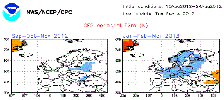
Indications a cold winter lies ahead for Europe.
Axel Bojanowski of Der Spiegel here also writes that two climate scientists, Hans Graf of the University of Cambridge and Davide Zanchettin of the Max Planck Institute for Meteorology in Hamburg, have developed a rule of thumb for predicting if it’s going to be cold or mild for the entire winter. How is this possible? Spiegel writes:
Graf and Zanchettin have discovered a weather kitchen that is mainly responsible for cooking up the winter for Central Europe. That kitchen is located on the other side of the planet in the Pacific the two climatologists report in a study in the “Journal of Geophysical Research”, which they submitted in the summer of 2011.”
They say it depends on the El Niño Southern Oscillation, which impacts weather globally.
According to Graf und Zanchettin: “After an El Niño over the Central Pacific, there’s a frosty winter in Europe – temperatures are on average 3 to 4°C lower than during other winters. Winters after El Niños are the coldest in Germany.”
Spiegel summarizes the rule of thumb the scientists use:
In Germany there’s a frosty, snowy winter when the following three conditions are fulfilled:
1.) For months there’s been an El Niño, meaning the ocean water surface is markedly warmer than usual.
2.) If the warm water spreads eastwards all the way to the coast of South America, then the chances for a cold winter in Central Europe drop off.
3.) There’s been no major volcano eruption – which would disrupt weather patterns.”
Leading climatologists Mojib Latif of the Helmholtz Center for Ocean Research in Kiel and Eduardo Zorita of the Helmholtz Center for Coastal Research, both in Germany, found the study to be of great interest. So once again Mr. Co2 warming Latif agrees that other factors drive the climate. An alarmist one day, and a scientist the next.
We’ll find out soon enough if Graf’s and Zanchettin’s rule will work for this coming winter.

Dang, I was hoping not to need new winter tires. Last winter was mild, the two before extremely cold at times and very snowy. At the start of the first one of those I slid off an iced-over Autobahn exit to avoid crashing the car in front of me… he had winter tires, I only summer tires and was coming up way too fast…
I drive with all-season tires. It’s enough for the flat country here.
http://www.osdpd.noaa.gov/data/sst/anomaly/anomnight.current.gif
It appears that El Nino is getting started this year.
Getting started? – or possibly ending:
http://www.bom.gov.au/climate/enso/indices.shtml
It appears starting, but we will soon see. Anything you are betting on?
http://www.cpc.ncep.noaa.gov/products/analysis_monitoring/enso_advisory/ensodisc.html
The lack of a clear atmospheric response to the positive oceanic anomalies indicates ongoing ENSO-neutral conditions.
Nearly all of the dynamical models favor the onset of El Niño beginning in July – September 2012 (Fig. 6). As in previous months, several statistical models predict ENSO-neutral conditions through the remainder of the year, but the average statistical forecast of Niño-3.4 increased compared to last month. Supported by model forecasts and the continued warmth across the Pacific Ocean, there is increased confidence for a weak-to-moderate El Niño during the Northern Hemisphere fall and winter 2012-13. El Niño conditions are likely to develop during August or September 2012 (see CPC/IRI consensus forecast).
testing something
Will Rome get more snow again, will it be like last year?
SOI was positive until recently. Shift it 9 months into the future and negate it and you get a predictor for global temperature anomaly.
http://www1.ncdc.noaa.gov/pub/data/cmb/teleconnections/soi-5a-pg.gif
This indicates that this winter could get cold and snow-rich, similar to the ones from 2010 to 2011 and from 2009 to 2010.