Looks like yet another model projection is about to join that now overflowing mass grave of failed climate and weather model projections. The latest to join it is the projection that 2014 would bring a “super El Niño”, and with it, the warmists are hoping, a new global temperature record.
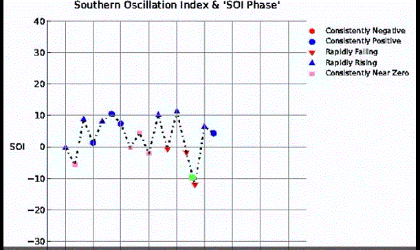
At Weatherbell Joe Bastardi has posted his latest Saturday Summary and in it he shows us why all of it is looking more like super El Hypo. Currently the Southern Oscillation Index (SOI) is positive, which, Joes says, makes it unlikely a “super El Niño” is in the pipeline this year. He says the current SOI value “has nothing to do” with a super El Niño.
At the 5:45 mark he shows the SOI plot of 1997, when it was seriously negative, dipping below -20.
He compares the 1997 SOI with today’s situation:
2014 SOI positive in June. Image cropped from Weatherbell Saturday Summary, 7 June 2017.
Currently, it’s still in positive territory, not what would expect to see in June! Joe then adds:
You need three months of plus 2°C or greater in the ENSO 3/4 and we just don’t see that and neiter do the models really.”
The charts show that there is no similarity with the event of 1997/98, and the current situation resembles more 2002 and 2009. The south Pacific is showing a cold PDO signature which “cuts the feet out from under” a developing El Niño.
Arctic ice poised for impressive rebound
At the 10:30 minute mark, the NWS/NCEP/CPC forecast shows how Arctic sea ice is projected to be above normal by late summer, something that has been unseen since 1996.
If that forecast should indeed pan out, then naturally skeptics are going to have a major field day with this. Just warning!
The NWS/NCEP/CPC forecast is even surprising Joe:
It’s forecast to stay above normal for 5 months at the height of the melt season. That has not happened since the AMO flipped from cold to warm back in the mid 90s. And that’s our theory that the Atlantic Decadal Oscillation, not CO2, that is controlling what the Arctic ice is doing – the bulk of the Arctic ice.”
With the latest projection, the warmists absolutely must be in major panic mode right now and gearing for major damage control. Expect them to be concocting some wacky explanation for this. I can hear it already: Warming causes more Arctic ice after all! The circus that climate science is becoming is taking on ever more impressive dimensions.
In summary, Antarctic sea ice is above normal, the Arctic is projected to be above normal this summer, and the super El Niño is turning out to be nothing but super el hypo.
Though the 2014 will end as a relatively warm year, it very very likely won’t be warm enough to end the streak in the warming gone AWOL, which is now close to being 18 years long. Moreover, El Niños are usually followed by (cool) La Niñas. The situation for the warmists is looking increasingly dire.

Thanks, Pierre.
Sometimes I find Joe B. making comments that need interpretation. The bit “…south Pacific is showing a cold PDO signature…” being one such. The PDO is defined for the North Pacific as done in this 1997 paper (page 1010): “NP: the extratropical North Pacific poleward of
20 N as in Davis (1976), …”
http://www.atmos.washington.edu/~david/zwb1997.pdf
Whatever Joe sees in the South Pacific may have some connection (similar cause?) as the PDO but it seems wrong to claim a “PDO signature.”
–————————————————
You write: “The situation for the warmists is looking increasingly dire.”
The truly ideological warmists will stick with their song & dance regardless of facts. What we can expect – if ice grows and warmth fades – is for those on the margins to quietly go do something else. Most of these folks are not high profile so not much notice will be made of this. In addition to age and retirement, there will be many reasons for changes in emphasis or direction. One example might be that those that pushed ethanol for fuel. Now that is recognized as not accomplishing much so an agricultural company could redirect research funds to improving food crops. A simple decision such as this will be unnoticed by those looking for the warmest movement to implode.
My guess is that they are hoping for a major hurricane hit.
We are at a period of extremely weak tornado and hurricane activity in the US. The frequency and intensity of them WILL eventually increase. During a lull in activity, if one predicts strong storms, they will eventually be correct.
They are hoping that when that time comes, they can say “see! you didn’t adopt our policies and look what has happened! This is all your fault!” when statistically it was bound to happen anyway. A repeat of the 1954 hurricane season would be an absolute propaganda bonanza for the “Warmanistas”.
Most of the hurricanes of that year raked up the East coast of the US. Ocean City, Maryland was devastated by Hazel. Today there are more high-rise hotels on that beach than there are at Miami Beach. Back then there were only a few one or two story wooden frame cottage hotels on “stilts” in the dunes.
They are going to attempt to portray a return to normal weather as being “extreme”.
Reference: http://en.wikipedia.org/wiki/1954_Atlantic_hurricane_season
The warmists are also doing it here in the Philippines Pierre. Last April-May, they announced of “severe, extended El Nino 2014” and projected water scarcity and rationing. By late May, rains have come, not too many but they are coming, so the fear of water rationing was abandoned. They try to bombard the public with news reports about rising sea level in XX cities and small Pacific countries, irreversible ice melt in Antarctica. Life goes on as the warmists panic for desperate stories.
Right…it was supposed to be the hidng-in-the-ocean global warming monster resurfacing.
There is not going to an El Niño at the end of this year.
I’m now able to claim that I know the physical mechanism which drives changes of ENSO while I have followed the data results I have got from my Artificial Neural Network I’ve built. The ENSO index is driven by a combination of tidal forcing and electromagnetic changes of the Sun.
Despite that I don’t know exactly the future changes in the electromagnetic changes of the Sun, I can make ENSO forecast. Of course it should be taken with a grain of salt.
I expect ENSO to be in La Niña or neutral mode at the end of this year.
At the end of 2015 ENSO is going to be in a weak or medium El Niño mode or possible in neutral mode.
If you’re right, those who projected a super El Nino are going to look a bit foolish.
They will. In April the SOI went all the way from El Nino back to neutral. It’s an 8 month predictor. No El Nino for the warmists.