Potsdam climatologist Prof. Stefan Rahmstorf is emerging as an outlier on the claimed polar vortex science behind this past winter’s extreme cold waves in the US and Europe.
German climate site Die kalte Sonne presented its 19th video which looks at Potsdam Institute Professor Stefan Rahmstorf’s claim of polar vortex instability being due to manmade global warming and thus behind the recent cold waves.
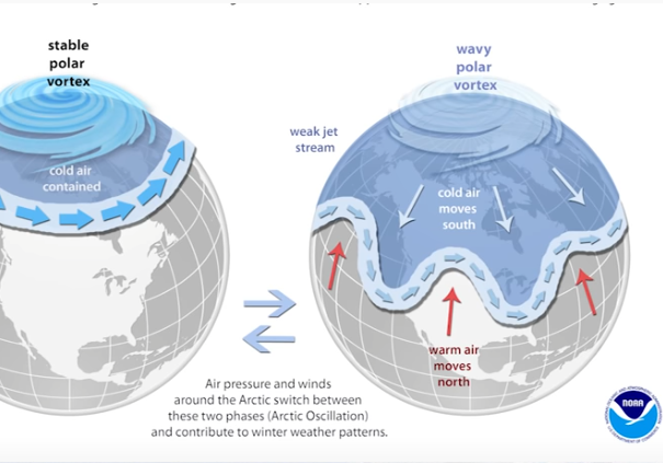
Image cropped: Klimaschau
Rahmstorf insists it’s manmade global warming
Rahmstorf claimed in a February online Spiegel article that the cold spells across North America, Europe and elsewhere were caused by the polar vortex being disrupted by man-made climate change.
Citing climate research done by his former PIK colleague Marlene Kretschmer, now at the University of Reading, Rahmstorf says the examined data from 1979 to 2018 show an increasingly unstable polar vortex.
But Kretschmer tweets: still “lots of uncertainty”
But then on February 16, Ms. Kretschmer tweeted a thread where she seemed to back off a bit on the theory, explaining that “lots of uncertainties” still remain:
Lots of discussions about the recent cold spell, the polar vortex and the role of climate change… Here is my two cents on this:
— Marlene Kretschmer (@Marlene_Climate) February 16, 2021
Need a “better understanding”
Kretschmer concluded at Twitter: “Bottom line: we need a better understanding of the different mechanisms (and associated risks) of how further Arctic changes (which are unfortunately certain in a warming climate) might affect our weather and climate.”
Domeisen, 2019: 170 years of data show no trend
There’s a reason behind Ms. Kretschmer’s reluctance to fully back her former Potsdam Institute colleague, Rahmstorf: A comprehensive publication by Daniela Domeisen, 2019:
Domeisen’s paper presented a chart depicting sudden stratospheric warming events over the past 170 years:
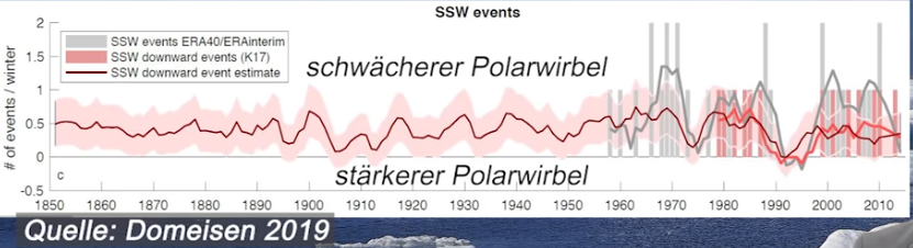
Image cropped: Klimaschau
Domeisen found that there have always been polar vortex fluctuations and abrupt stratospheric warming throughout the long period, and that overall there has been no real detectable frequency trend – a major blow to Rahmstorf.
Rahmstorf misinterprets short term as “long-term”
Kretschmer (and Rahmstorf) focused only on a 39-year period, too short to allow sound conclusions.
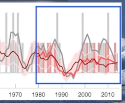
Image cropped: Klimaschau
Kretschmer gets it, but Rahmstorf refuses to acknowledge Domeisen’s results and allows himself to be seduced by pure climate variability and willfully misinterprets the short 39-year trend as a long-term anthropogenic trend.
“Rahmstorf should know better”
“Rahmstorf should know better,” says Die kalte Sonne.
Just a week before Rahmstorf blamed the US and European cold waves on manmade warming on Spiegel Online, the NOAA had issued the following statement:
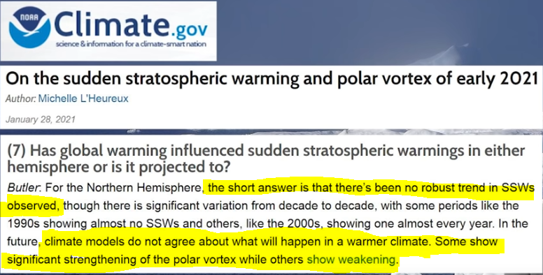
“No robust trend,” the NOAA found. “Climate models do not agree.”
Domeisen and the NOAA clearly make Rahmstorf the outlier.
Spiegel editor was a former Greenpeace magazine writer
So how did Rahmstorf’s article get by Spiegel’s strict editorial standards? Probably because Spiegel Online deputy chief science editor Kurt Stufenberg used to work many years for Greenpeace magazine.
It’s about activism, not science.


The last 39 year polar vortexes seem to be just past solar minimum.
I don’t understand Fig.1. Cold air moves everywhere from the north to the south. There must be a counterflow of warm air from the south to the north.
You are correct. The Arctic becomes warmer during a polar vortex. Here’s the explanation from NOAA: “When the vortex weakens, shifts, or splits, the polar jet stream often becomes extremely wavy, allowing warm air to flood into the Arctic and polar air to sink down into the mid-latitudes.”
That is correct. That’s the case where the polar jet stream flow becomes what is known as HIGHLY amplified – allowing warm air and cold air to make long-distance excursions along the equator-pole axis.
And don’t forget that during the northern hemisphere winter, the real “factory” for the generation of cold air isn’t the north pole, but Siberia; it’s “manufactured” there and then can spread out in various favored directions based on the jet stream flow and the behavior of the “polar vortex” – southward into the Himalayas, eastward into Korea/northern-Japan, westward into Europe, or northward and over-the-pole into North America.
There will come a day that no one pays the slightest bit of attention to anything Prof. Stefan Rahmstorf and his ilk has to say.
Not in my lifetime, unfortunately.
The Notrickzone.com to me is one of the few websites standing above the political and “scientific” sea of insanity! I see it interesting that the main media never mention about the likely influence on the Earth climate of so many satellites orbiting the planet…
What about the influence of the massive usage of electromagnetic energy radiating from the cell towers and cell phones around the world?
Greetings to everyone!
As per Joe Bastardi’s Saturday summary, the cold coming into Texas was due to a high pressure, NOT the polar vortex. Listen here starting at 5:42…
https://www.weatherbell.com/video/the-saturday-summary-236?full
It’s just weather. Unusual weather, but weather none the less.
Both Joe and Richard Lindzen have complained (justifiably) in recent years that it seems that no one in so-called “climate science” knows a blessed thing about operational meteorology; Rahmstorf apparently has that problem.
It’s pretty basic stuff that cold air is associated with higher air pressures – as cold air is a) dense, and b) tends to sink to the surface because of this. It’s why a semi-permanent high pressure area sets up over Siberia during the winter – ultra-cold and with absurdly high pressure values (often reaching 31.00 inches).
The polar jet stream stuff is also basic and well-known. I could rattle on for a long time about longwave features in the hemisphere-encircling flow, amplified flow vs. zonal flow, etc., etc., etc. – but won’t bother because it’s beyond Rahmstorf and his ilk…
Rahmstorf also makes same sort of falsehood with the AMOC as well. My opinion is that the PIK often resembles a science con-racket.
It’s a religion – more specifically, a crackpot paleolithic cult… but one that is very lucrative for the phony-baloney “shamen” like Rahmstorf et al.
These behaviors are well-known and nothing new and are doing nothing they haven’t done before.
Here’s a really neat animation of several days of the behavior of the polar jet stream over North America:
https://svs.gsfc.nasa.gov/3864
LOL – looks like a dynamic Van Gogh painting.
https://cdn.shopify.com/s/files/1/1993/6065/products/MS471_992x851.jpg?
@The Indomitable Snowman, Ph.D.
Now that’s useful “feedback.” 🙂
If you have any links to intro to basics on that, I’d like to see them. I don’t see myself becoming fluent in it, because as I can tell from Bastardi’s weekly summaries, it takes a good deal of experience to recognize how weather behavior around the world is linked. It’s not rocket science, but it does require decades of hands-on pattern recognition. Still some basics might familiarize me with enough of the jargon that I can have more appreciation for what’s going on, at least qualitatively.
Let’s see if I can get my next book out – hopefully this year.
A surprisingly-useful little intro to upper level weather can be found here:
https://www.weather.gov/jetstream/constant_intro
Walk through that; it covers a lot of these topics… and rather well.
Thanks
And that’s a good one, too, because it illustrates the problem with AGW hype. In an overall warmer climate, the gradients are shallower, so severe weather is less likely, not more.
“the gradients are shallower, so severe weather is less likely, not more.”
That’s pretty much the size of it – and that’s another point that Joe has raised repeatedly.
Severe weather is caused by the atmosphere being “unstable.” In meteorology, “unstable” has the specific meaning that the air aloft is much colder than the air at the surface; if the air aloft is colder than what would be expected from the adiabatic lapse rate, then the atmosphere is unstable. Stability and instability refer entirely to the buoyancy of a parcel of air near the surface and its ability to rise; in an unstable atmosphere, such a parcel can rise higher and more-rapidly (higher velocity = higher kinetic energy, as kinetic energy is proportional to the square of the velocity).
A good example of that is to compare Florida and Oklahoma. Florida leads the galaxy in thunderstorm occurrence – but severe thunderstorms are actually rare there. In Florida, the air aloft is usually very warm, and so the instability is rarely strong; most Florida thunderstorms are garden-variety pop-up airmass thunderstorms. In Oklahoma, particularly in the spring, the actual lapse rate tends to be much steeper than the adiabatic lapse rate – due to cold temperatures aloft; this causes instability and stronger thunderstorms. Toss together warm, moist Gulf air at the surface being warmed by the strong spring sun, cold still-winter air aloft, and a strong cold front to provide additional lift… and you’ve got atmospheric TNT.
Good explanation!
BTW, I realized that that link goes into the middle of something much larger – an entire on-line course on weather that actually is pretty good.
https://www.weather.gov/jetstream/
“…an entire on-line course on weather that actually is pretty good.”
Yes. I noticed that. It looks promising.
Rahmstorf has just published a non-paper titled “Current Atlantic Meridional Overturning Circulation weakest in last millennium”.
(I say ‘non-paper’ because it is labelled “Brief Communication” – whatever that is. Is it a paper that can’t be critiqued?)
He is not named as the lead author – he has left that role to one of his minions (“LC”) – but he is one of the authors. You don’t have to dig very far, however, to find, “S.R. initiated the study. L.C. created the figure and wrote the manuscript. N.C. performed the significance testing”.
He is very vague (deliberately so, I suspect) about the relationship between the Atlantic Meridional Overturning Circulation, the Gulf Stream, and the Thermohaline Circulation.
I suggest a reading of late prof. Marcel Leroux (removed from WIKI for non-sufficient contribution to the society to deserve an entry) on – as he calls it – POLAR HIGH. Basically, a blurb of high pressure, separating from the polar vortex and happily traveling down to the equator, causing blocking highs (heat waves in summer, beasts from the east in winter). But his (very expensive and unavailable) book gives a good SCIENTIFIC explanation of facts. And he is not using numerical models for it. A very good reading