A new study suggests British Columbia (Canada) relative sea levels remained 10 meters higher than they are today until they fell to their present levels in the last ~1800 years. Two other new studies suggest sea levels were still 0.8 to 1 meter higher than today during the Medieval Warm Period.
After the peak of the last glacial about 20,000 years ago, relative sea levels subsequently rose from 120 meters below modern sea levels to heights of 90 meters above today’s by ~14,500 years ago in the Douglas Channel near British Columbia, Canada (Letham et al., 2021).
Sea levels proceeded to fall 75 to 80 meters over the next 3000 years, or about -2.5 meters per century (-25 mm/yr), and then they remained 10-15 m above present for the next ~9000 years.
“We determine that central Douglas Channel was ice-free following the Last Glacial Maximum by ∼14,500 BP and RSL was at least 90 m higher than today. Isostatic rebound caused RSL to fall to 21 m asl by 11,500 BP, though there may have been a glacial re-advance that would have paused RSL fall around the beginning of the Younger Dryas. RSL fell to 10–15 m asl by 10,000 BP, and continued to drop at a slower rate towards its current position, which it reached by ∼1800 years ago.”
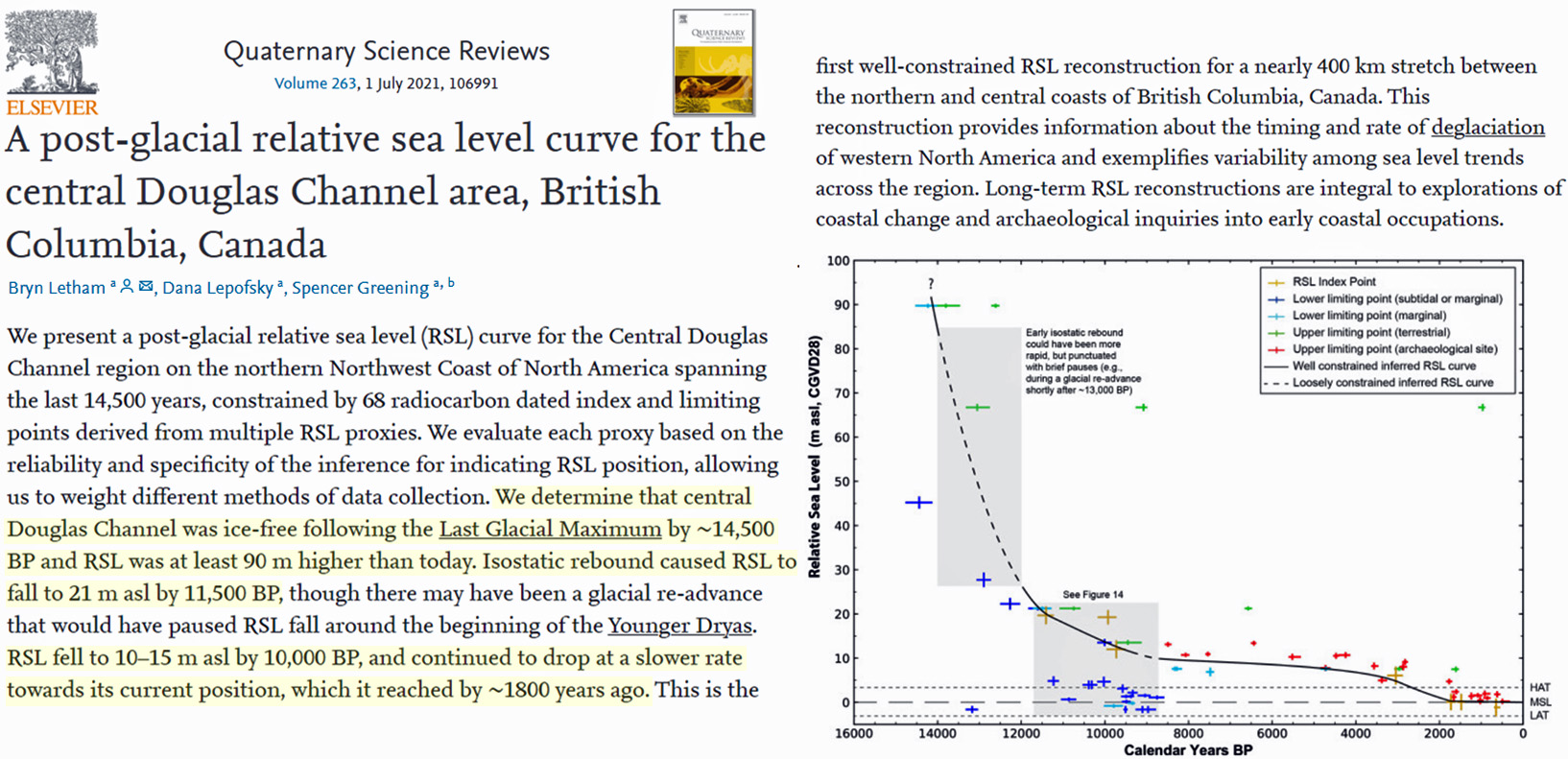
Image Source: Letham et al., 2021
Steffen et al., 2020 proposed relative sea levels peaked at 32 meters above today’s levels in Nanotalik (southern Greenland) during the latter stages of the last ice age (13,800 years ago).
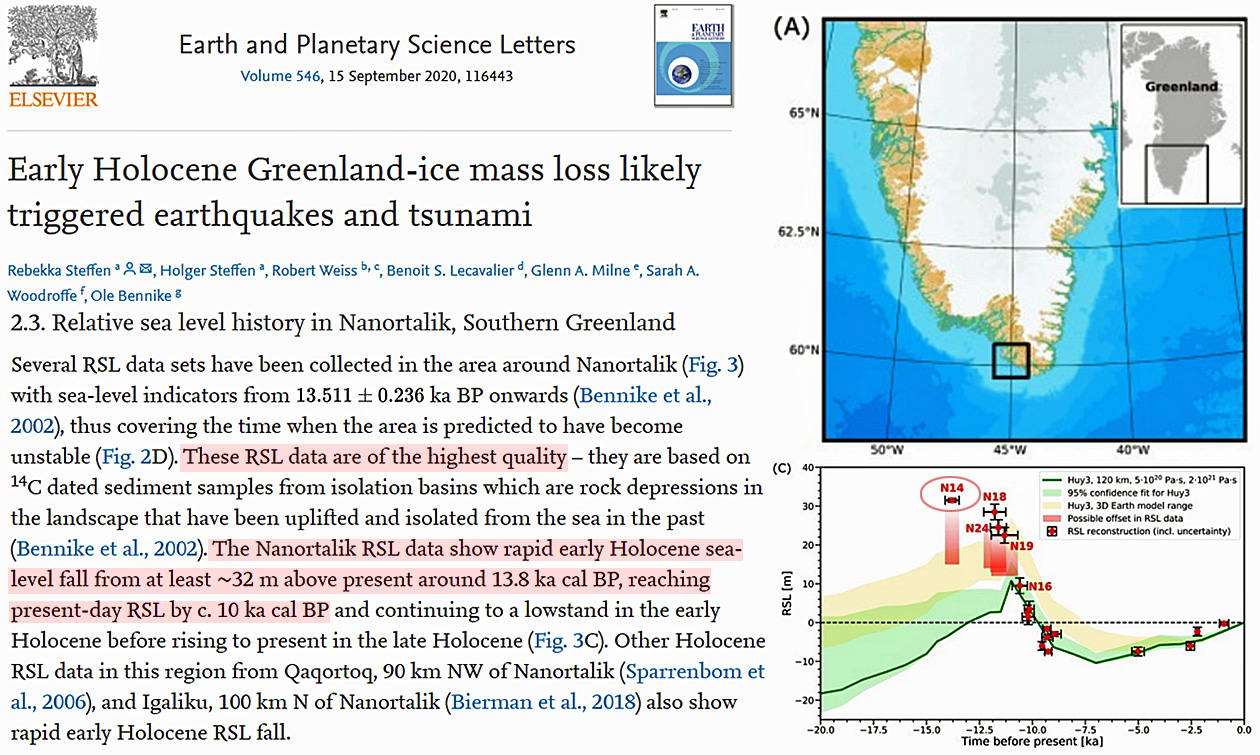
Image Source: Steffen et al., 2020
Sea levels were reportedly about 40 meters higher than today 15,000 years ago along the coasts of western Norway (Bondevik et al., 2019).
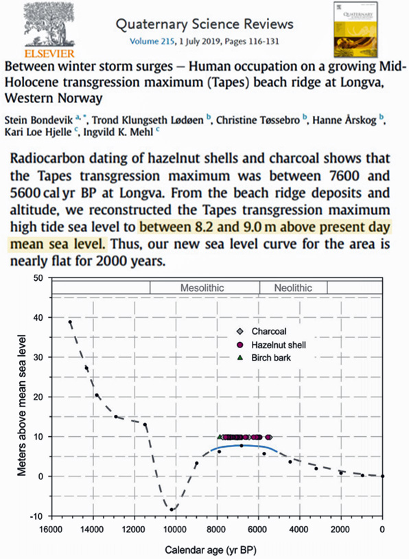
Image Source: Bondevik et al., 2019
For the Southern Hemisphere, a 2011 study (Watcham et al.) reported Antarctica’s sea levels were at least 15 meters above today’s 9000 years ago. Falling sea levels have been ongoing since then, with an especially pronounced acceleration in declining sea levels in the last 500 years.
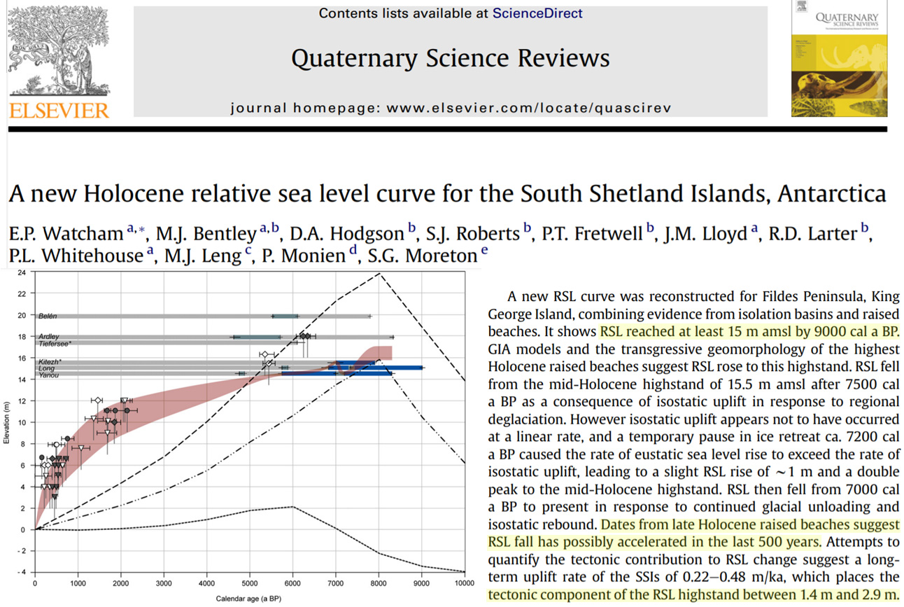
Image Source: Watcham et al., 2011
Two more new studies indicate the relative sea levels along the coasts of Bangladesh (Haque and Hoyanagi, 2021) and South China Sea (Yan et al., 2021) were still about 0.8 to 1.2 meters higher than today’s during the Medieval Warm Period.
None of these studies have sea level trajectories that even remotely align with changes in the atmospheric CO2 concentration that ranged from 230 ppm 14,500 years ago to 270 ppm during the Medieval Warm Period.


“Sea Levels Near B.C. Canada Were 90 Meters Higher Than Today 14,500 Years Ago.” Probably a typo. Elsewhere, they were 130 meters lower than today.
“Probably a typo. Elsewhere, they were 130 meters lower than today.”
Yes, vertical land motions for the regions of the world still rising today (i.e., Pacific NW, Alaska, Scandinavia…) can have dramatically different relative sea levels vs. regions where VLMs are more quiescent.
Consider Sweden’s coasts were 2 meters higher than now in 1731. If sea levels can fall by 1.5 to 2 meters per century (like they are along the coasts of Alaska today), it takes only 3,000 years for RSLs to be 50-60 m higher.
Along the coasts of western Norway, sea levels were reported to be 40 meters higher 15,000 years ago per Bondevik et al., 2019.
It’s not as if this featured new paper (B.C. Canada) is a stand-alone. As the article shows, Greenland and Antarctica had much higher RSLs too. If anything, these studies indicate just how dynamic the Earth system is, self-facilitating dramatic shifts in both eustatic sea level changes and VLMs.
In most location where this phenomena happened, has to do with isostasy. Today, lots of locations in Scandinavian peninsula, the se is apparently still retreating but, as a matter of fact, is the landmass that is locally rising. In most location not subjected to the weight of thick sheets of ice, the se was 120 to 140 meters lower than the present level.
That’s a common phenomenon all over the northern hemisphere in regions that were under a mile-deep ice sheet during the last glacial era. Lake Champlain in the NE US (divides Vermont and New York, and extends north into Quebec) was ocean when the ice melted 10,000 years ago – but is now 100 feet (about 30 meters) above sea level and is still rebounding upward (do the math on the annual rate – something like an inch a year).
My understanding is that Loch Ness in Scotland has been doing something similar over the past 10,000 years (was ocean, now rebounded up higher and thus became fresh water).
90 meters higher sounds like baloney to me.
This is why we have to stop Man Made Global Warming. If it goes on at this rate, all the sea will evaporate and there will be no seas left.
maybe some Letuja Bay event?
[…] From the NoTricksZone […]
These papers created severe cognitive dissonance for me. The above comments helped.
Sorry for the typo errors in my last comment. Beware that these studies relate to relatively high latitude regions. In these locations, at glacial maximum, the weight of the ice led to an isostatic compensation of crustal sinking. Since the glacial maximum, these regions have been on a slow rise. Thus it is not the sea level that is falling but the crust that is slowly rising. Even today, in several circumpolar-polar regions, for instance in Scandinavia, the sea is apparently receding. This is stated in the studies. In the rest of the planet, especially in mid to low latitudes, the sea level was 120-140 metres below the current level and has naturally been rising.
It seem to be confusing but it is not. The crust is very dynamic horizontally (tectonics) and vertically (tectonics, isostasy, etc.). These studies are perfectly online with the bet geologic knowledge that we have from crustal processes.
The Clovis people arrived in the Western Hemisphere ostensibly 13,500 years ago, over a land bridge between Siberia and North America. From the Letham paper “After the peak of the last glacial about 20,000 years ago, relative sea levels subsequently rose from 120 meters below modern sea levels to heights of 90 meters above today’s by ~14,500 years ago in the Douglas Channel near British Columbia, Canada”
The story about the arrival of the Clovis people may need work.