Data: Colorado State University, NOAA
Overview
Tropical cyclone activity across the Northern Hemisphere has been below-normal in 2021 in much the same way as it was last year. Specifically, while the Atlantic Basin featured above-normal tropical activity in this year and last, the Pacific Ocean experienced below-normal conditions in both years leading the way to below-normal levels across the hemisphere as a whole.
In terms of tornadoes, it has been another below-normal season in the US with no EF-5’s recorded. There was, however, tornadic activity in some unusual places in 2021 including the Mid-Atlantic and New England.
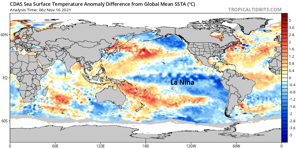
Colder-than-normal sea surface temperatures continue to dominate the scene in the equatorial part of the Pacific Ocean. These “La Nina” conditions likely played an important role in the above-normal tropical activity across the Atlantic Basin in 2021 and the below-normal activity in the Pacific Ocean. Map NOAA, tropicaltidbits.com
Northern Hemisphere Tropical Activity…below-normal
There is no tropical activity right now in either the Atlantic or Pacific Ocean and none is expected in the near term. In fact, the tropical activity in both of these large bodies of water may very well be done for the 2021 season and there has been a rather dramatic drop off of activity in recent weeks. In fact, the quiet period in terms of tropical activity began in October and it turned out to be rather unusual in that there were no “major” hurricanes (Category 3 or above) anywhere across the globe.
October surprise
According to Dr. Philip Klotzbach of Colorado State University, this is the first time since 1977 that there were no “major” hurricanes during the month of October anywhere across the globe. Furthermore, in the period from mid-October to mid-November, the accumulated cyclone energy (defined below) across the globe was the lowest in the satellite era (since 1966).
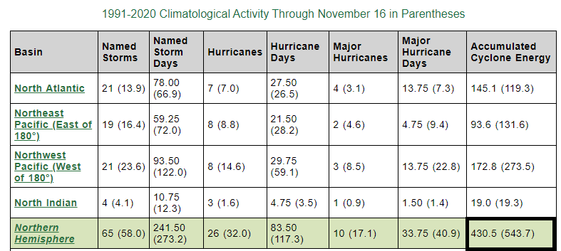
The 2021 Atlantic Basin was above-normal in terms of the number of named storms (21) making it the third most active on record when using that particular metric.
There is another metric known as the accumulated cyclone energy (ACE) that meteorologists tend to favor in order to assess overall tropical activity in a given season. The ACE metric – which was originally created by Dr. William Gray and associates at Colorado State University and later tweaked by NOAA – not only factors in the intensity of a tropical cyclone, it also takes into account its longevity.
Average energy per storm much lower
While the “number of storms” in the Atlantic Basin this season was ranked quite high on the historical scale, the average ACE per storm was much lower down on the rankings with past seasons. This result is indicative of the fact that many of this year’s named tropical systems were short-lived and/or relatively weak.
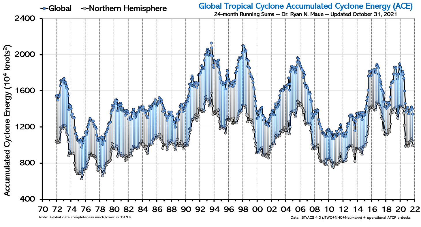
Last 50-years+ of Global and Northern Hemisphere Accumulated Cyclone Energy: 24 month running sums. Note the year indicated represents the value of ACE through the previous 24-months for the Northern Hemisphere (bottom line/gray boxes) and the entire global (top line/blue boxes). The area in between represents the Southern Hemisphere total ACE. Courtesy Dr. Ryan Maue
Elevated Atlantic activity linked to cool equatorial Pacific
The above-normal activity in the Atlantic Basin this year (and also in 2020) was fueled in part by La Nina conditions in the equatorial part of the Pacific Ocean. Typically, colder-than-normal sea surface temperatures in the tropical Pacific Ocean (i.e. La Nina conditions) lead to reduced overall wind shear in the tropical Atlantic Ocean and this, in turn, is a favorable factor for the formation and intensification of tropical cyclones in that part of the hemisphere.
Suppressed Pacific activity
While La Nina conditions were a favorable factor for tropical activity in the Atlantic Basin, it tended to suppress activity in the equatorial part of the Pacific Ocean. In both regions of the Pacific Ocean (i.e. to the east and west of the “international date line”), overall tropical activity was below-normal this season in terms of accumulated cyclone energy. The drop off in activity in the Pacific Ocean began as early as the month of September in that there was only one named storm (Olaf) making it the least active month since 2010.
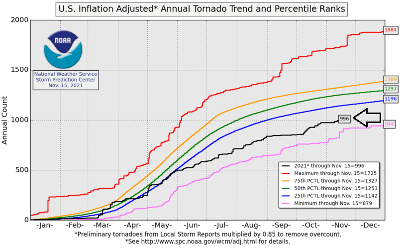
Of all the countries around the world, the US has the highest number of tornadoes and this year has been below-normal across the nation. The annual tornado trends chart is a result of the following methodology applied to the SPC observed tornado dataset by Harold Brooks, NSSL and Greg Carbin, NOAA/SPC.
Details: A simple linear regression equation is fit to the 1954-2007 annual tornado totals. This equation is then used to compute the delta, or difference, between the original/observed annual tornado total and the smoothed, or “adjusted” annual total represented by the point on the linear trend line for that year.
US tornadic activity…below-normal
2021 has been a below-normal year in terms of number of tornadoes across the nation falling below the “25th percentile. The United States has the most tornadoes of any country, as well as the strongest and most violent tornadoes. Despite several outbreaks in March and another large outbreak at the beginning of May, the year as a whole remains below-average due largely due to inactivity during the months of April and June.
Unusual tornado activity
While the nation as a whole has experienced less tornadic activity than normal, there have been some areas that have experienced unusual action. For example, the Mid-Atlantic region experienced an unusual tornado outbreak this mid-summer that had its origins in the Upper Midwest.
On July 29th , numeric tornadic supercells developed across the eastern Ohio Valley and Mid-Atlantic resulting in many tornadoes. In fact, a few of the tornadoes were strong and damaging including an EF-3 tornado that caused severe damage in the Philly suburbs of Trevose and Bethlehem. It was the first EF-3 tornado in lower Bucks County ever, but an F3 tornado came through Central Bucks some 125 years ago in 1896, according to the National Weather Service.
Another unusual tornado caused damage in southeastern Pennsylvania during the late summer (9/1/21) as an EF-2 touched down in the Philly suburb of Fort Washington.
In addition, in just the past week, there was an unusual tornado outbreak in portions of New York and New England. On Saturday, November 13th, strong storms generated at least 11 confirmed tornadoes that touched down in New York State and New England with all being classified as EF-0 or EF-1.
According to the Eastern Region NWS, there were 6 tornadoes on Long Island (plus one Friday in the mid Hudson Valley of New York State), 4 in Connecticut and 3 in Rhode Island (2 of the tornadoes crossed from CT into RI). According to the NWS, there had not been a tornado recorded in Connecticut or Rhode Island in the month of November since 1950.
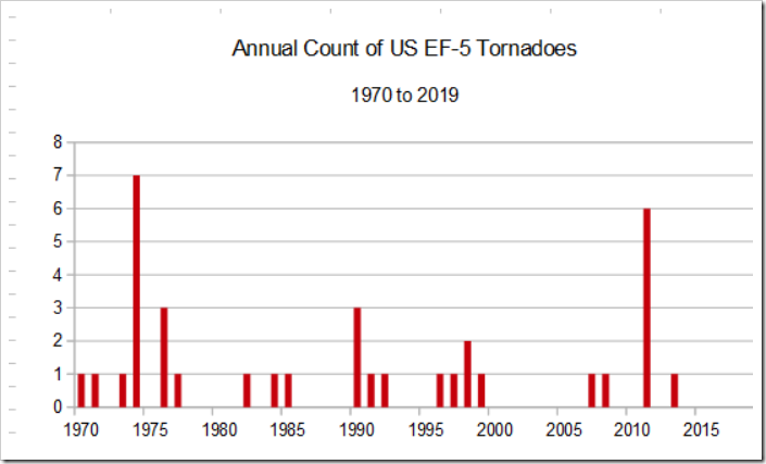
According to NOAA’s Storm Prediction Center (SPC), the last recorded EF-5 tornado – the most violent classification level – was in the year 2013
No EF-5 tornado in 8 years
One of the notable findings of the 2021 US tornado season is that it featured no EF-5 tornadoes which are the most powerful of all. In fact, it has now been more than 8 years since the last EF-5 tornado struck in the US which was in Moore County, Oklahoma during May of 2013. According to NOAA, there have been a total of 36 EF-5 tornadoes in the US since 1970 with 14 of those occurring in the 1970s.


[…] Below Normal Extremes…2021 Northern Hemisphere Cyclone Activity Below Normal…US Tornadoe… […]
There is a statistical issue with rare weather events such as EF-5s, massive snow falls, or high temperature “waves.”
Being rare there is not much of a “distribution” to use to discuss them.
Thus, when one occurs it gets lots of attention.
Sure is interesting though.
Thanks.
OT – Vax
https://www.bitchute.com/video/eosnwyX7qNUT/
Trouble in Israel.
[…] Below Normal Extremes…2021 Northern Hemisphere Cyclone Activity Below Normal…US Tornadoes Below … […]
[…] From the NoTricksZone […]
[…] From the NoTricksZone […]
[…] From NoTricksZone […]
[…] From the NoTricksZone […]
[…] From the NoTricksZone […]