Germany’s leading tabloid has a report today called: Expert: More and More Extreme Weather In Germany. What is this claim based on?
It’s based on short-term observations made by official Bild tabloid meteorologist Dominik Jung, who is quoted as saying:
Just take a look at the monthly deviations in average temperature in Germany from 2010. There you’ll notice an almost symmetrical up and down. Every positive extreme has a corresponding negative.”
One year of data says this will be the case for the future, with extremes even growing wider? So claims the Bild weatherman. Strangely, Bild refers to Jung as “Der Klima-Experte” (the climate expert). I thought meteorologists and climatologists were completely different. Obviously, when one makes extreme forecasts of disaster, then it qualifies a person as a “climate expert”.What data does Jung use to draw his extreme weather conclusion?
Numerous weather exremes resulted from the temperature anomalies last year, such as the coldest May since weather records are kept, and the long lasting heat wave of June-July, or multiple high water in East Germany.”
In summary, Jung bases his climate projection on 3 events that occurred in one single year. And my recollection is that the “long lasting heat wave of June-July” was a whole three weeks long, starting at the end of June and extending to about July 22, and was interrupted at least twice by cooler weather. What the heck – good enough to count as an extreme.
Jung then admits in the Bild article that no “general increase in storms or significant weather events” could be detected“, yet, storms will become “always more extreme and violent”. No trend is there? So what – let’s make a sensational baseless prediction – just for the tabloids!
Just how good a meteorologist is Jung? Not very good if you examine his forecast for the winter. On November 9, 2010 Bild published his seasonal forecast for the 2010-2011 winter, predicting Germany would have a very mild first half of December with temperatures reaching 15°C!
The exact opposite was the case.
He also predicted a short thaw in early February, then followed by another cold snap that would extend deep into March. That now looks doubtful. January and February have been a bit over normal, and looks to continue that way. But let’s give him credit where it is due: he predicted a white Christmas, which turned out right.
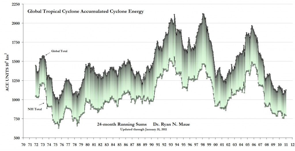
Lately we have been hearing a lot about weather extremes, many claiming 2010 was an extreme weather year globally. Just how extreme was 2010? You be the judge, from http://www.coaps.fsu.edu/~maue/tropical/:
For the calendar-year 2010:
**66-tropical cyclones globally, the fewest in the reliable record (since at least 1970)
**46-tropical cyclones in the Northern Hemisphere, fewest since 1977
**Global calendar year ACE total of 529 was the lowest since 1977.
**The Northern Hemisphere ACE total of 373 was the lowest since 1977.
**Combined North Eastern and Western Pacific ACE total of 171 lowest since at least 1970.
**Western North Pacific had 8 Typhoons fewest in at least 65-years of records.
**Eastern North Pacific had 8 TCs: 3 were hurricanes, the fewest since at least 1970.
**North Atlantic ACE for 2010 was 170, the 11th most since 1950, and most since 2005.
Overall, since 1979:
**Global Tropical Cyclone ACE shows no upward trend.
**Northern Hemisphere TC ACE shows no upward trend.
**Southern Hemisphere TC ACE shows no upward trend.
**North Atlantic TC ACE has doubled since 1995, exactly compensated by a halving of Eastern Pacific ACE. It appears that in the context of global and NH ACE, the NATL increases are at the expense of the other basins, or simply within the common climate framework.
**Global TCs of Tropical Storm force show no upward trend in frequency.
**Global TCs of Hurricane Force + show no upward trend in frequency.”
Tropical cylone ACE looks to be close to a record low. But that kind of news news doesn’t qualify to be printed in sensationalist tabloids.


You gotta love to debunk such claims.
Here are monthly anomalies for German territory since 1850:
http://climexp.knmi.nl/data/icrutem3_5-15E_47.5-55N_n_sua.png
Monthly anomalies in more detail, 2000-2011:
http://climexp.knmi.nl/data/icrutem3_5-15E_47.5-55N_n_su_2000:2011.png
The only thing which is interesting on 2010 is, that temperatures are in free-fall, even the whole “warmest decade ever” is going pretty much downhill.
To see whether the monthly records are getting more “jumpy” because of GCD (global climate disruption), you just run the dataset to get annual standard deviation:
http://climexp.knmi.nl/data/icrutem3_5-15E_47.5-55N_n_su_sd1.png
The result is unambiguous – 2010 is nothing special and the climate, at least in Germany, was less stable in the past (if we take monthly deviation from mean as a metrics).
You can do the same even with daily data for given meteorological station with daily temps or precipitation. I have yet to find a station, which shows increasing SD and I tested a lot of them.
Thanks Juraj. Jung’s weather office is obviously running a tabloid of its own.
Is this it?
http://vortex.nsstc.uah.edu/data/msu/t2lt/
No sorry wrong link will try again
http://www.coaps.fsu.edu/~maue/tropical/
Now I will get my coat
Excellent! Thanks Green Sand.
This should do it:
http://wattsupwiththat.com/2011/02/08/rebuttal-to-the-climate-rapid-response-team/#more-33529
I’m really getting sick and tired form the BS published in the press nowadays and the lame warmist arguments.
They are hacks and scam artists and the time has come to treat them that way.
Tomorrow I’m going to post an essay that explains why these people are like that.
Willi Dansgaard passes, LA Times botches obit
The L.A. Times notes the passing of pioneer ice core scientist Willi Dansgaard but neglects to mention that the “clear link between carbon dioxide and methane concentrations and global temperatures” found in his ice cores shows that CO2 and CH4 increase follows temperature increase, not vice versa.
http://www.heliogenic.net/2011/02/07/willi-dansgaard-passes-l-a-times-botches-obit/
“Icelandic volcano ‘set to erupt’ ”
http://www.telegraph.co.uk/news/worldnews/europe/iceland/8311924/Icelandic-volcano-set-to-erupt.html
“Scientists in Iceland are warning that another volcano looks set to erupt and threatening to spew-out a pall of dust that would dwarf last year’s event. “
Could make for some interesting winters, and summers!
It’s a pity that it is not Katla, who looked so promising last year. We need a lot of volcano eruptions at the cool side of our charity bet.
Mindert, don’t be diffused by some volcanologists who want more seismic equipent installed. There is no indication for any eruption in Icealnd for the time being.
On a historical time scale Katla however is overdue and past eruptions have shown a time leg of about 18 months for katla to erupt after Eya.
We’ll know soon enough when something happens over there.
In the mean time we have over a dozen of volcano’s erupting in other places like Indonesia, Kamchatka, Japan, South- and Middle America to mention a few places.
So I don’t really understand the fixation on Iceland.
Just for the record:
New Activity/Unrest: | Galeras, Colombia | Kirishima, Kyushu | Mayon, Luzon | Popocatépetl, México | Tengger Caldera, Eastern Java (Indonesia)
Ongoing Activity: | Bulusan, Luzon | Karymsky, Eastern Kamchatka (Russia) | Kilauea, Hawaii (USA) | Kizimen, Eastern Kamchatka (Russia) | Sakura-jima, Kyushu | Sangay, Ecuador | Shiveluch, Central Kamchatka (Russia) | Taal, Luzon|Chaitén, Chili.
That’s more than a dozen all right.
[…] thanks to a review of Leroux’s book: “Tabloid climatology”. Pierre Gosselin touched on the label last year as well. This is an excerpt from his book, as documented by Thayer Watkins at San Jose State […]