The calendar says it’s summertime in the Arctic. But looking at the latest weather forecast, you’d never know it. In fact it looks more like September.
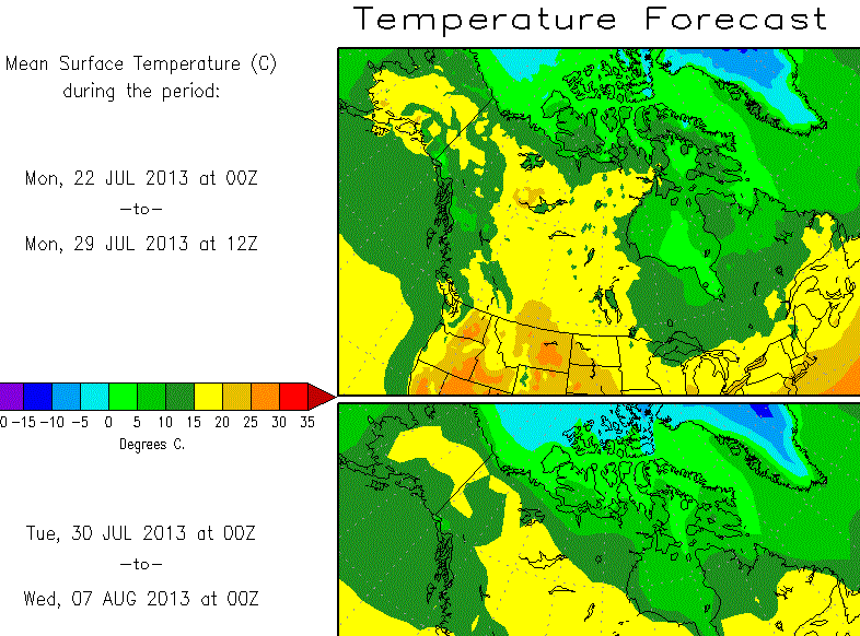
Here’s what the temperature forecasting chart shows today:
The above chart based on the NCEP shows frosty days up ahead for the Arctic. Source: http://wxmaps.org
Ellesmere island, the 12th largest island in the world, will be about 5°C below normal over the coming week. A large part of the Arctic will be below freezing by early August, according to forecasts. This flies in the face of “accelerated warming” that is supposed to occur in the Arctic. Sea ice as a whole will come close to a modern low, but so has the temperature!
Steve Goddard at his website has written on multiple occasions about how it’s been the coldest summer in the Arctic on the (modern) record. Here’s the summer temperature chart for this year thus far:
Coldest Arctic summer on record. Source: http://ocean.dmi.dk
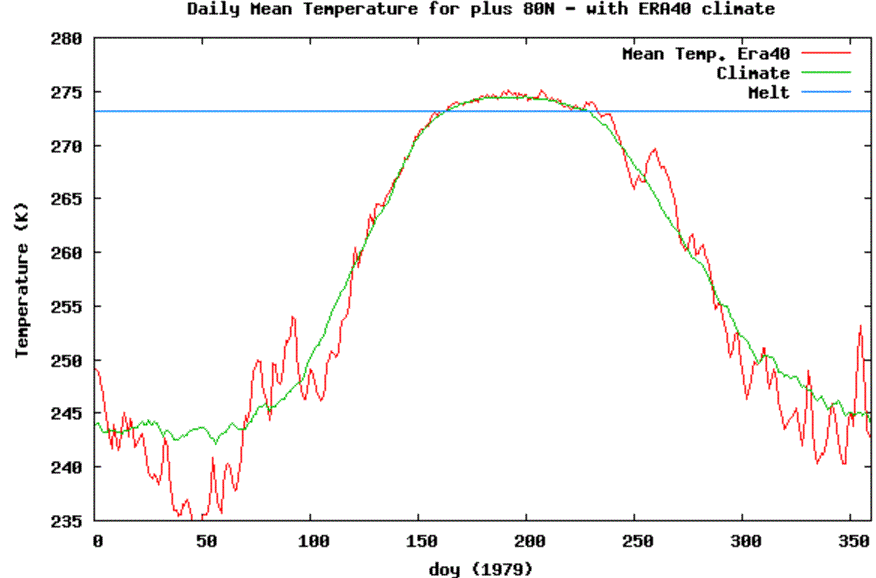
Now here’s the temperature chart for the Arctic back in 1979 when all was “normal” up in the Arctic and the polar bears had more sea ice than they knew what to do with:
Summertime temperature for the year 1979 – back when Arctic sea ice was at a maximum. Source: http://ocean.dmi.dk.
.



S hem is nothing short of dramatic with current winter cold over antarctica
The biggest thorn in side is amazing dry air over tropics, crashing the ACE yet again and debunking trapping hot spot theories, along with doom and gloom about enhanced global tropical cyclones. Given the implication of what temperatures really mean, the polar regions are side shows to the biggest indictment of all, the lack of trapping hot spots and the model busts
Chilling phrase:
Reduced evaporation?
Back to the weather of the (mid to late) 1970’s here in (SW) Western Australia. A winter that appears to be dry but the rain comes in (heavy showers) for 2 to 4 day spells with intermediate dry spells of about a week. That’s different to the winters where successive El Niños “dominated”; with what seemed to be long wet periods of light precipitation or long dry periods.
Much of our rain comes from the NW; the “middle” of the Indian Ocean. Rain on the South coast often comes from the Southern Ocean, rain which is notionally less likely in winter, when evaporation is lower from the cold waters. However, the cold air mixes with the warm near the land and that, not infrequently, results in precipitation.
The UK metoffice are still in denial
http://www.telegraph.co.uk/news/uknews/10195498/Global-warming-on-pause-but-set-to-resume.html
“Global warming has been on “pause” for 15 years but will speed up again and is still a real threat, Met Office scientists have warned.”
For what reason will the warming speed up again if the heat escapes into the oceans? Is the water boiling already?
An early winter could be a problem for these guys
http://mainstreamlastfirst.com/
Love to know what the Russians are doing with their nuclear icebreakers up in the Arctic. ‘Rate’ of Arctic ice loss looks very close to storm induced loss last year. Just curious.
O/T everybody noticed? Old friend Dana Nuccitelli is a normal rent seeker employed in the rent-seeking green energy / Fossil fuels juggernaut.
http://wattsupwiththat.com/2013/07/22/dana-nuccitellis-vested-interest-oil-and-gas/#comment-1369111
O/T stock quote of troubled Hamburg PV company Conergy recently underwent a new collapse. Endgame?
http://www.comdirect.de/inf/aktien/detail/uebersicht.html?ID_NOTATION=47825310