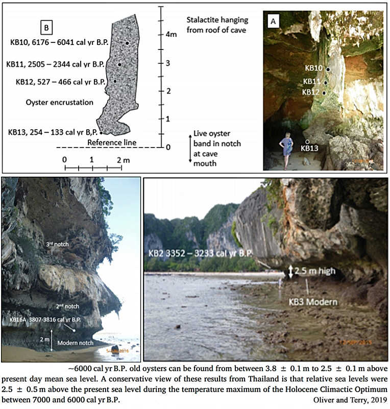
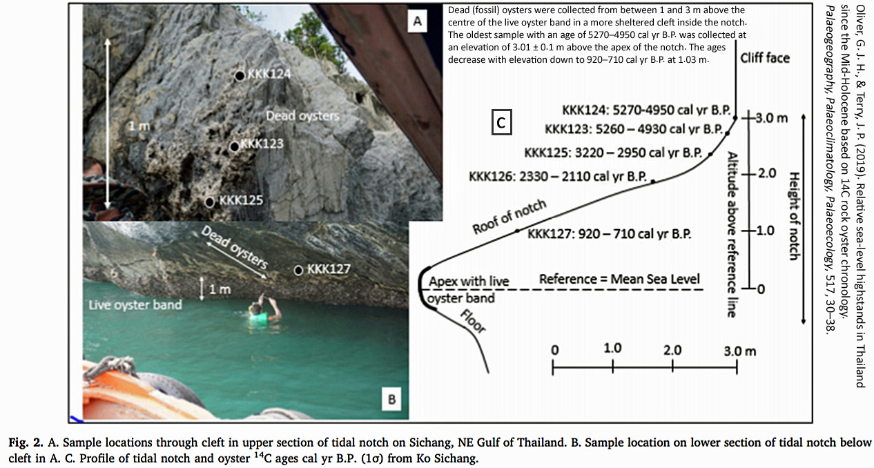
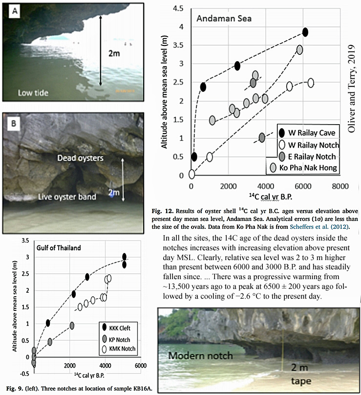
According to a new paper (Oliver and Terry, 2019) published in Palaeogeography, Palaeoclimatology, Palaeoecology, oyster remains have been found encrusted in rock 2.5 to 3.8 meters above the present mean sea level. This fossilized evidence dates to ~6000 to years ago, a period when the Earth’s surface temperatures were 4-6°C warmer than they are today.

Image(s) Source: Oliver and Terry, 2019
The evidence provided by Oliver and Terry (2019) will be added the to growing list of more than 80 scientific papers indicating sea levels from locations throughout the world were meters higher than they are today just a few thousand years ago.
80+ Papers: Mid-Holocene Sea Levels
Were Multiple Meters Higher Than Today
Oliver and Terry, 2019
Relative sea-level highstands in Thailand since the
Mid-Holocene based on 14C rock oyster chronology
• “~6000 cal yr B.P. old oysters can be found from between 3.8 ± 0.1 m to 2.5 ± 0.1 m above present day mean sea level. … Dead (fossil) oysters were collected from between 1 and 3 m above the centre of the live oyster band in a more sheltered cleft inside the notch. The oldest sample with an age of 5270–4950 cal yr B.P. was collected at an elevation of 3.01 ± 0.1 m above the apex of the notch. The ages decrease with elevation down to 920–710 cal yr B.P. at 1.03 m.”
• “In all the sites, the 14C age of the dead oysters inside the notches increases with increasing elevation above present day MSL. Clearly, relative sea level was 2 to 3 m higher than present between 6000 and 3000 B.P. and has steadily fallen since.”
• “There was a progressive warming from ~13,500 years ago to a peak at 6500 ± 200 years ago followed by a cooling of −2.6 °C to the present day.”
• “Generally, there is a ~1 m wide live oyster band (with modern 14C ages) in the apex of the sea notch that corresponds to the present day MSL. 14C ages of dead oysters are systematically older higher up the sea notch and reach a maximum 14C cal yr B.P. age of 6513–6390 cal yr B.P. at an elevation of 2.5 ± 0.1 m above present day MSL in an exposed site at West Railay Beach. Consequently, relative sea levels must have been higher in the mid Holocene than they are now.”
• “[A]t a more sheltered site inside a bay on Ko Pha Nak, the highest preserved oyster shell is at 3.2 ± 0.1 m above MSL and has a younger 14C calibrated age of 5845–5605 cal yr B.P. Furthermore, oysters from 3.8 ± 0.1 m above present day MSL, encrusted on a stalactite in a cave at West Railay Beach has a 14C calibrated age of 6176–6041 cal yr B.P.”


I have personally seen this in Dubai. I am a geologist so I know what offshore beach bars look like even when they are miles from the current Arabian Sea.
I haven’t read all of the above yet, but have they ruled out rebound post ice age melt off?
Of course that might be a difficult sell for anywhere in the Middle East, which were doubtless not buried under miles of ice. ;o)
Considering the last glacial maximum ice extent never came close to reaching the equatorial regions, no, this isn’t rebound.
http://web.gccaz.edu/~lnewman/gph111/topic_units/glacial/glacial2.html
Right. That’s basically what I wrote in my second paragraph. But it could happen as a result of other geological forces. The M.E. is geologically very complicated, and there is at least some uplift due to seismic activity.
http://webdoc.sub.gwdg.de/ebook/serien/tm-v/STR/0504.pdf
https://www.researchgate.net/publication/215755730_Combining_satellite_and_seismic_images_to_analyze_the_shallow_structure_of_the_Dead_Sea_Transform
Actually, I was hoping to prompt Doug Proctor to shed some light on it by his commenting further on the region. It could be very interesting, IMO.
http://atlas.geo.cornell.edu/htmls/gsa_today.html
It must be a fascinating place for a geologist to work.
Indeed. I probably shouldn’t have been so definitive in saying no. The crust of the Earth moves vertically, and in both directions, for reasons that are not necessarily determinable.
And these vertical land motions can easily exceed (and thus amplify or completely counteract) the rate of sea level rise, reaching + or – 10 mm/yr. See this graph from Pfeffer et al. (2017) for the trends in vertical land movement at tide gauges across the world.
https://notrickszone.com/wp-content/uploads/2019/01/Vertical-land-motions-observations-at-coasts-during-1993-to-2013-Pfeffer-2017.jpg
Pfeffer et al., 2017
https://doi.org/10.1093/gji/ggx142
“Since the last glacial maximum (LGM ≈ 21 000 yr ago), the solid Earth responds to the melt of the continental ice sheets and is still in a state of isostatic disequilibrium (e.g. King et al. 2010). The ongoing glacial isostatic adjustment (GIA) causes changes in the Earth’s rotation rate, gravity field, geocentre and shape. The vertical displacement of the Earth’s crust can exceed 10 mm yr−1 across previously glaciated areas (e.g. Sella et al. 2007; Milne et al. 2001). Driven by mantle convection, tectonic plates move at the Earth surface at the pace of a few centimetres per year. In the vicinity of plate boundaries, large VLMs are associated with seismic and volcanic events. During the earthquake cycle, tectonic stress accumulates along faults generating interseismic VLMs, which may range from ±1 to ±10 mm yr−1 and last for decades (e.g. Ballu et al. 2011; Smith-Konter et al. 2014). … In addition, VLMs contribute actively to the sea-level changes felt by coastal populations, as they can amplify, diminish or counteract the effects of climate-induced signals (e.g. Pfeffer & Allemand 2016). In many cases, for example, Torres Islands (Ballu et al. 2011), western Tropical Pacific (Becker et al. 2012), southern Europe (Woppelmann & Marcos ¨ 2012) or Indian Ocean (Palanisamy et al. 2014), VLMs [vertical land motions] have been recognized as a dominant component of the total relative sea-level variations observed at coasts.”
I agree (with seeking DP’s insight). Didn’t intend to make it appear I was “shutting you down” with my comment, but reading it again I can see how it could be interpreted that way.
I too am fascinated with geothermal/geological process and how they relate to sea levels, glacier retreat, and climate.
Thank you. Yes. Very nice.
(Didn’t think you were trying to “shut me down,” but that perhaps I wasn’t clear enough.)
Also, I’m wonder what, if anything, the notching of the rock face by the ocean can tell us. It looks like the sea level drop occurred in unequal steps, with some lasting longer than others.
Douglas Proctor – Can you shed light on what may be a similar situation in the Bay of Campeche. Look at the Google satellite view of the area around Frontera. There is a very interesting complex of elevated beaches, including evidence of the apparent beheading of Rio Usumacinta by Rio Grijalva. I can find no literature on these features. Plainly sea levels have gone down, but I don’t know over what time period and whether there has been uplift sufficient to cause this.
So, it looks like the warmists thought they had a safe bet. All they had to do was tell us what would happen as the world warmed naturally (elevated temps, melting ice, rising seas, etc.), and blame it on CO2, tell us it was our fault and the only way to fix it was to give them total control of us and our money. How would we know the difference? The perfect scam.
Well, along comes the internet and the free flow of information so that the “marks” (targets of the scam) can get to hear both sides and chose for themselves what makes sense. The perfect antidote.
I’ll bet Al Gore is kicking himself now for “inventing the internet.” //snarc//
Oh, and they also tell us it’s dangerous and soon will be unstoppable if we don’t act NOW!
There. Did I forget anything else?
Looks good, thanks.
There is a small problem with this post.
• “In all the sites, the 14C age of the dead oysters inside the notches increases with increasing elevation above present day MSL.
This is the reverse of the normal stratigraphic progression.
It’s not possible to deposit younger sediments under an older deposit.
Something else might be happening at this site.
“the 14C age of the dead oysters inside the notches increases with increasing elevation above present day MSL.”
The quote is saying that the older (~6,000 ka BP) oyster remains are higher in elevation on the rock (i.e., the sea levels were higher) than the younger (3,000 ka BP) oyster remains. The younger deposits are “under” the older deposits vertically. The older deposits are not overlaid on top of the younger ones in the same location on the rocks.
Yes, thanks.
I realised that 60 seconds after posting.
A case of read more comment less.
Cheers
All’s good, Anthony.
Litorina sea had left us with a ridge at that level in south of Sweden.
This part of Sweden has no land lift due to ice decompression (anymore?)
It was during the same period that the ridge was shaped as a seashore.
And yes, the water had high salinity indicating contact with the Atlantic.
An obvious overshoot of oysters, a die-off was necessary.
The sea level drop due to earthquake activity could raise or lower the shallow areas of a seabed and there you go, oysters above the water line, the shore is gone.
Oysters are edible, so knock yourself out. All at once, they’re gone. And… they’re gone.
More than likely, the polar regions contained less ice and more water resulted from a melt of the ice caps.
Everything always goes Lake Missoula.
Yesterday was cold, a high temp of minus eleven was on record.
It is minus 21F at the moment. Too cold to even think.
Other places it is -30F. Another bad winter, just like all the rest. You gotta have shelter, otherwise, you’ll freeze to death. It’ll be a hard day on the planet. You wonder how the hardy reindeer herders in Siberia can do it. They have to have shelter. Think of the poor reindeer turned into coats and sausage.
Record lows range in the minus 42F up to minus 25F, most took place from 1915-1920 time period, accuweather is a source for the information.
People get sick when cold weather sets in, the flu epidemic, pandemic, in 1918 can be attributed somewhat by the inclement winter weather during those years. Blame the Spaniards on that one. No, it was the war, American militaries joined the fight over in Europe, another one, and some of the soldiers were infected with the blasted Spanish flu, it then spread hither and yon.
“The winter of 1917/1918 is referred to as the Great Frost Winter in Iceland. It was the coldest winter in the region during the twentieth century. It was remarkable for the presence of sea ice in Reykjavik Harbour as well as for the unusually large number of polar bear sightings in northern Iceland. Here we use observations as well as two reanalyses that span the twentieth century to document this event. We show that throughout much of the region, January 1918 was the coldest winter month on record. The North Atlantic Oscillation (NAO) attained one of its most negative values during January 1918 and the westward shift in its northern centre of action allowed cold Arctic and Greenlandic air to penetrate south towards Iceland.”
https://rmets.onlinelibrary.wiley.com/doi/10.1002/qj.2939
Winter weather at its best a century ago.
The record lows I see from the accuweather weather data seem to/do coincide with what was observed then in Iceland.
Colder than hell out there right now, dangerous weather.
Must have a wobble and swing of a hundred year duration.
All of the ingredients in beer contain all of the nutrients to keep you alive. More CO2 in the atmosphere is needed to get that Barley at optimum growth potential.
Laughter is the best medicine.
[…] https://notrickszone.com/2019/02/07/oyster-evidence-affirm-sea-levels-were-up-to-3-8-meters-higher-th… […]
[…] https://notrickszone.com/2019/02/07/oyster-evidence-affirm-sea-levels-were-up-to-3-8-meters-higher-th… […]