Clouds, not greenhouse gases, are the decisive drivers of our weather, our energy status and hence also our climate. The need to get away from the over-simplistic idea of CO2 being the control knob
Demystifying “greenhouse gas” claims – Part 3
By Fred F. Mueller
In Part 1 we looked at the deplorable tendency of climate doomsayers to reduce the factual complexity and variability of parameters influencing our climate and declaring CO2 to be the only major control knob dictating climate development and other factors wilfully suppressed 1).
In part 2, it was shown that the reality of radiation energy transfers in the atmosphere depends mainly on clouds, who can act as decisive inhibitors preventing sunlight from reaching the surface and/or as massive sources of infrared energy radiation down to earth.
Today in Part 3, we investigate some interesting professional meteorological findings backing the results of logical conclusions that can be verified by anybody using pricy DIY instrumentation and common sense in combination with some information available on the internet.
This proof of concept underscores the idea that clouds, not greenhouse gases are the decisive drivers of our weather, our energy status and hence also our climate.
The Hamburg weather mast
This is the 300-meter high broadcasting mast of the North German Broadcasting Co. located in the transition region between rural and urban land use, some 8 km outside the city center. The mast has been equipped with sophisticated meteorological instrumentation at several height levels, with the highest platform at 280 meters above ground. The station also has a separate 10-m mast and a standardized meteorological ground station as well as aggro-meteorological instrumentation monitoring the conditions from surface level to different depth levels down to -1.2 meter. It is run by the Meteorological Institute at Universität Hamburg in partnership with the Max Planck Institute for Meteorology. Operated since 1967, the station has been revamped with cutting-edge data acquisition technology 2) in 1994. Continuous monitoring records are maintained since 1995.
Data are recorded at high rates and the corresponding values of most of them are updated on their website 3) at fixed intervals. Additionally, continuous graphics for 2-day 4) and 8-day periods are displayed on separate sub-pages. This also includes computed values such as sunshine duration, daily global radiation and the balance between incoming and outgoing radiation energy fluxes at ground level. Although the meteorological institute maintains a massive database of data records, these are not made available to the general public. Full access is limited to meteorological institutes and networks, exceptions may be granted to other researchers and professional users. This is all the more deplorable since it prohibits critical minds of the public from accessing data that have, after all, been assembled using taxpayer’s money.
Selected interesting data recordings
Fig. 2. Two-day recording of the global solar input density over the time of day from Jan.15th to Jan 17th, 2023 (red) compared to the theoretical max value (Graphic: Wettermast Hamburg).
Global solar energy input density is recorded as the sum of direct and indirect solar radiation from sunrise to sunset. In the 2- and 8-day graphs, the corresponding values are compared to a dome-shaped yellow curve representing the theoretical max value calculated for the current latitude and the sun’s position for the current date and the actual time of day. Several other values such as the daily integrated energy input are also put on display.
Clouds
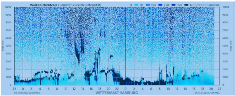
Cloud cover is recorded with a ceilometer that differentiates between several superimposed layers, Fig. 3
Fig. 3. The ceilometer records the height and density of different cloud “floors” up to a height of 10.000 meters. 2-day recording from Jan. 15th, 2023 to Jan. 17th, 2023 (Graphic: Wettermast Hamburg)
Fig. 4. Computer generated diagram representing the coverage index of four different cloud floors on a 1/8 scale. Dark blue represents full cover of the lowest cloud layer and full white segments are clear sky conditions. 2-day recording from Jan. 15th, 2023 to Jan. 17th, 2023 (Graphic: Wettermast Hamburg).
Fig. 5. Additionally, cloud base temperature is monitored using an IR temperature probe, shown her combined with the computed cloud cover diagram. Recording from Jan. 15th, 2023 to Jan. 17th, 2023 (Graphic: Wettermast Hamburg)
IR radiation and radiation balance
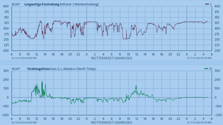
Fig. 6. Recordings of the downwelling IR radiation (upper graph) and the computed total radiation balance at ground level from Jan. 15th, 2023 to Jan. 17th, 2023 (Graphic: Wettermast Hamburg)
The calculations performed to establish the values of the lower graph include the global solar radiation density recorded at ground level, the downwelling IR radiation emitted from above, an albedo value of 0.21 and the IR emissions upwelling from the ground calculated from the surface temperature under the assumption of a constant emissivity factor of 0.984. The website states that this calculation delivers fairly good values if the surface is covered by a green meadow but cautions this is not the case when there is a closed snow cover.
In this context, it should be noted that in situations with a high cloud cover index in conjunction with low-altitude clouds, the downwelling IR radiation flux density is matching values established using the simplified SB-equation described in Part 2 of this article fairly well. During times with higher clouds and lower cover values, the downwelling IR radiation intensity recedes by about 75 W/m2, leaving a residual level of around 225 W/m2. The examples shown below underscore the fact that the varying cloud cover has an enormous and highly variable influence on the energy flux balance at ground level. Due to the fact that the institute data base is not accessible to the public, all samples presented here were collected in January 2023.
Example 1: a day with a largely even energy balance
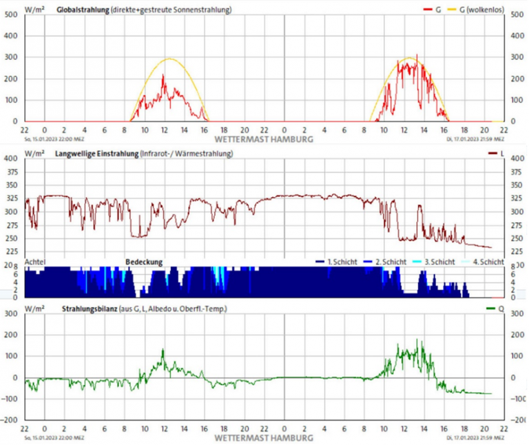
Fig. 7. Superimposed graphs of global solar radiation density (upper graph), downwelling IR radiation density (second graph), cloud cover index (blue) and the computed balance of the varying radiative fluxes from Jan. 15th to Jan. 17th, 2023. (Graphic: Wettermast Hamburg)
The decisive information of Fig. 7. is the lower graph showing the computed radiation balance at surface level. Despite the cloud cover receding slightly after 08.15 am on Jan. 16th, 2023, , the moderately high solar input from 8.45 am to 16.15 pm does not seem to push the daily total significantly into positive terrain. The increasing IR output from the thick cloud cover developing after around 22.00 pm largely compensates IR radiation losses from the surface until at around 8.45 am the next day. From then on, the sun is able to deliver considerable energy input. But with the cloud cover disappearing after 13.0 pm, the receding IR input from disappearing clouds tips the balance decisively into negative territory despite the sun continuing to weigh in. After sunset at about 16.15 pm, the negative trend reaches -75 to -80 W/m2.
Example 2: a day with a clear cooling effect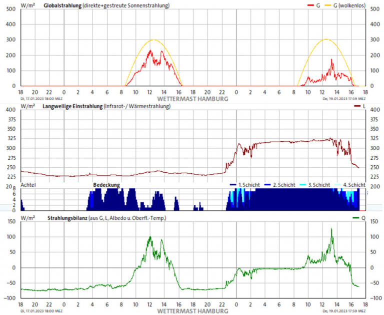
Fig. 8. This figure displays the continuation of the trend shown in Fig. 7. from Jan. 17th throughout Jan. 18th and into the 19th (Graphic: Wettermast Hamburg)
Fig. 8. shows that the high energy losses caused by upwelling IR radiation from the surface are not compensated for from downwelling IR radiated from clouds. This continues throughout most of the night until about 3.30 am on the 18th, when a moderate reappearance of clouds reduces the losses to some -55 to -65 W/m2. From 8.20 am on, moderately high input from global solar radiation piercing through a thinned cloud cover pushes the balance upwards to positive peaks reaching up to 100 W/m2. Note that the cloud cover was apparently not thick enough to produce a noticeable increase in downwelling IR radiation, which is consistent with the relatively high level of global solar radiation the clouds have let shine through. Fading input from the setting sun and losses from upwelling radiation due to a largely clear sky tip the balance into the red from about 15.10 pm with a rapid descent until about -70 to -75 W/m2 until about 22.15 pm. Then a slowly thickening cloud cover gradually reduces the balance losses until a jittery equilibrium is reached shortly after midnight. A stabilizing cloud cover then steadies the curve slightly in negative territory until the dawning sun drives it upwards again. Finally, a sharply downward trend from a combination of setting sun and fading cloud cover results in a very steep decline of the energy balance from 16.00 pm on. On balance, Jan. 18th has seen a marked cooling effect caused by a sometimes poor (and ill-timed) cloud cover.
Cloud effects are real and far stronger than those of “greenhouse gases”
This evidence strongly backs the thesis that the decisive role of energy exchanges in the system surface/ atmosphere has to be attributed to the interaction of clouds with the radiation energy fluxes in the system. Even in mid-winter, the variance within a day can span between +180 and –80 W/m2. Compare this total span of 260 w/m2 to the alleged +3.11 W/m2 attributed to the “forcing” exerted by the combined “greenhouse gases”. They differ by a factor of more than 80. And keep in mind that the values presented here have been collected in mid-winter, when all radiative fluxes are much lower than in the summer. Looking at these facts, it is really astonishing that in most discussions about the impact of water vapor on weather and climate, the role of clouds is simply ignored. Thinking of water vapor as a mere passive amplifying factor for CO2 is a twist of reality.
Global climate trends should be computed from local data
In this context, one should keep in mind that climate is not “global”. There are different definitions, e.g. for paleoclimate research, but usually, climate is understood to be the long-term weather pattern in an area, typically averaged over 30 years 5). It is usually expressed by the median values of all relevant weather events in the given area over the agreed time period. More general conclusions should only be drawn based on data collected using a sufficiently dense network of meteorological stations ideally distributed all over the globe. Satellites are useful but cannot do the job alone: there are many essential values that cannot be recorded remotely from space with sufficient accuracy. Basing climate calculations on “median” values often extracted from simulations instead of taking into account the real local variations – such as e.g. globalized mean albedo figures instead of the values corresponding to the local cloud situation – is thus of rather restricted value.
As we have seen, the variations in the local energy status are a vital factor for assessing local meteorological changes. Air temperature changes at a height of 2 meters are largely a result of the underlying fact that energy levels of matter – be it air, soil or water – have been altered.
CO2 a pint-size climate driver
The real climate behemoths of the planet are the ground and the oceans, which store and release (and in the case of oceans also disperse) much higher amounts of energy than the thin air cover of our planet. Our current air-temperature-centered approach stems from meteorologists of e.g. the 18th and 19th century. These had neither the required modern scientific knowledge nor the necessary instrumentation to understand the real relations between energy, phase transformations, chemistry, physical chemistry and heat. This still influences our current weather and climate approach that is still too air-condition-centered. Science tells us that the thermal capacity of the oceans is about 1,000 times higher 6) than that of the atmosphere, and soils also play a bigger role than air. For this reason air temperature at 2 metres is just a variable suited for weather forecasts. But when looking at long-term climate assessments, air temperature is just the tail unable to wiggle the big energy dog represented by the exchange of enormous energy quantities between the earth system and space.
This historical background explains why meteorological stations that are able to perform the recordings and computations shown here are still rare exceptions. The existing network should be upgraded in order to monitor the main factors impacting on local energy level changes. This would also be helpful in overcoming the current tendency to define fruitless “one knob for all” parameters while ignoring the way more powerful factors that really drive the evolution of our climate.
In the next parts, we will look at the variabilities and trends in cloud-sun interaction and current discrepancies with respect to rain.
Sources:
1) https://climate.nasa.gov/ask-nasa-climate/3143/how-atmospheric-vapor-amplifies-earths-greenhouse-effect/
2) https://wettermast.uni-hamburg.de/frame.php?doc=MessanlageEng.htm
3) https://wettermast.uni-hamburg.de/frame.php?doc=Einzelwerte.htm
4) https://wettermast.uni-hamburg.de/frame.php?doc=Zeitreihen48h.htm
5) https://en.wikipedia.org/wiki/Climate
6) https://scholarsandrogues.com/2013/05/09/csfe-heat-capacity-air-ocean/






[…] From NoTricksZone […]
Simply look at the cloud cover over the oceans. Fewer clouds mean more visible radiation reaching the oceans, which means global warming. It is that easy and has nothing to do with CO2.
Good point
But keep in mind the dual role of clouds. More clouds will block more sunlight from reaching the surface. Cloud cover acts as a long-term self-regulating sunlight filter keeping the earth’s temperature in a range that will support life. Has been so for > 3.5 billion years or so.
Links to parts 1 and 2?
[…] Measurements Show Cloud Effects Are Real, Far Stronger Than Effects Of “Greenhouse Gases” […]
https://notrickszone.com/2023/01/14/a-diy-guide-to-demystifying-greenhouse-gas-claims-the-science-that-cuts-corners/
https://notrickszone.com/2023/01/18/climate-scientists-using-grossly-simplified-deplorably-unrealistic-models-and-assumptions/
An excellent review of the effect of cloud, but why bother with carbon dioxide? It is an innocuous cooling trace gas.
Carbon dioxide is among several gases that radiate solar energy away from Earth and absorbed solar energy back to space. That activity is visible in the satellite image of that deep gorge in the graph of outgoing terrestrial energy.
It does not multiply energy. Physical bodies including radiation-active molecules reach thermal equilibrium by interacting mutually in a tendency toward uniform temperature. This change, thermalization, is exclusively in the form but not amount of energy.
Next, half a dozen studies confirm that CO2 concentrations FOLLOW temperature change as an effect and are not a cause of that change. Cool to warm or the reverse, it doesn’t cause anything.
The consensus “solar constant” of 1,361 W/m2 established by the Earth’s “Total Solar Irradiance,” is a meaningless number here because radiation-interactive molecules do so only at individual quantum-determined spectral bands at integers exactly matching the their electron energy levels. Nothing, except the hypothetical (imaginary) blackbody surface could ever interact with TSI, the entire solar spectrum.
As an infrared radiation active gas, CO2’s principal spectral band peaks at about 15 microns wavelength at 193K, 80 Celsius degrees below water’s freezing point. The next most active band at 9.6 microns (at 29°C) but passes with other 8-12 micron radiators through the atmospheric window to space.
Re-emission of solar energy by carbon dioxide is not at the Earth’s 288K blackbody temperature but where general air temperatures are 210 to 220K characteristic of 10.5 km to 22 km altitudes. Because temperature from 11 km to 20 km in the tropopause, is at an almost constant 217K, more radiation from between these altitudes will not move the altitude of effective or equilibrium radiation level (ERL) with space. (It also raises a question whether CO2’s interaction, consistently at 193K, has any effect on the ambient atmospheric temperature at any altitude.)
The “Tropical Hot Spot,” the fingerprint of warming, has never been found and most likely does not exist, strongly favoring no CO2- altered equilibrium radiation level.
Why go on about imaginary greenhouses? Let’s junk the term. Climate is super-cold (-170°C, -180°C) atmospheric gases erupting away against gravity from the Earth’s scalding hot (-18°C) solar heated surface to release the energy to space.
You can’t tax clouds like CO2, thats why carbondioxide is perfect for politics of global warming.
Politics is not interested in whats warming the globe just what you can put a tax on if sciense say that the warming is due to clouds politicians will ignore that sciense because there is no money in clouds.
For some years now, I have been submitting to my contacts studies on the
radiation of water droplets from clouds to explain the emission spectrum of the
atmosphere observed by meteorological satellites.
A difference with the text of Fred F. Mueller is that this infrared radiation
also comes from the air at altitude because it is partly composed of micro water
droplets (the sky is washed out blue and not dark blue at the zenith as in
Elisabethville in Katanga where I observed at noon an already very dry air from
the ground in the dry season).
No one has shown interest in evaluating the radiation from clouds (large drops)
and air (fine drops) and verify my assessments.
Is it possible to contact Fred F. Mueller in English or French?
Water drops radiate 10-2-23
Sir,
In your first three texts in Notrickszone, you establish the importance of the
albedo for the climate and, more specifically, of the clouds. This ridicules the
role that can be attributed to CO2 in terms of radiation.
You are announcing a 4th text but, until now, you specify that the drops of
water from the clouds send back part of the solar radiation towards space but
you do not point out that, secondly, the surface of the drops of water radiates
towards the empties the heat content of water droplets, and third, these
surfaces powerfully radiate much of the sky’s average 300 watts down to the
ground, day and night.
I am afraid that, like most of my colleagues in this type of research, you think
that it is the water vapor (an invisible gas) of the cloud that only manifests
itself.
However, a cloud, saturated with water vapor (invisible gas) contains no more
than the air at the same altitude, or barely. It is therefore the surface of the
drops that provides most of the powerful infrared radiation of a cloud.
And there is much more important: the blue of the sky is (almost) always washed
out (milky), because it is enriched with fine drops of water. Those who could
live in really dry places, could see the blue of the soft sky, at the zenith,
towards the black (and I could see Venus at the zenith at 10am in Katanga in the
dry season).
Conclusion: does the Planck curve, which weather satellites pick up as thermal
emission from the atmosphere, essentially come from these drops?
NB. A column of warm air radiates. I measured it, without possible bias (?), and
yet, it does not contain drops of water but its water vapor (invisible gas)
which radiates, therefore, it too….
What do you think ?claudebrasseur@gmail.com
Water drops radiate 10-2-23
Sir,
In your first three texts in Notrickszone, you establish the importance of the
albedo for the climate and, more specifically, of the clouds. This ridicules the
role that can be attributed to CO2 in terms of radiation.
You are announcing a 4th text but, until now, you specify that the drops of
water from the clouds send back part of the solar radiation towards space but
you do not point out that, secondly, the surface of the drops of water radiates
towards the empties the heat content of water droplets, and third, these
surfaces powerfully radiate much of the sky’s average 300 watts down to the
ground, day and night.
I am afraid that, like most of my colleagues in this type of research, you think
that it is the water vapor (an invisible gas) of the cloud that only manifests
itself.
However, a cloud, saturated with water vapor (invisible gas) contains no more
than the air at the same altitude, or barely. It is therefore the surface of the
drops that provides most of the powerful infrared radiation of a cloud.
And there is much more important: the blue of the sky is (almost) always washed
out (milky), because it is enriched with fine drops of water. Those who could
live in really dry places, could see the blue of the soft sky, at the zenith,
towards the black (and I could see Venus at the zenith at 10am in Katanga in the
dry season).
Conclusion: does the Planck curve, which weather satellites pick up as thermal
emission from the atmosphere, essentially come from these drops?
NB. A column of warm air radiates. I measured it, without possible bias (?), and
yet, it does not contain drops of water but its water vapor (invisible gas)
which radiates, therefore, it too….
What do you think ?