EIKE Cold Report No. 33 (excerpts)
By Christian Freuer, Electroverse
Europe’s best start to a ski season in a long time
Contrary to mainstream groupthink, reality is once again smacking climate alarmism in the face.
Recently, ski resorts from the French Alps down to the Italian Dolomites reported almost a meter of fresh snow, resulting in a historically early start to the European ski season.
And the forecast sees much more through early December.
Absurd notions that Europe’s favorite winter sport is a thing of the past have suffered a setback after temperatures across the region fell off a cliff in November, back to a “crisp climate like in the 1990s,” reports goodnewsnetwork.org.
Fukuoka, Japan, sees earliest snowfall in 40 years
On Sunday, November 19, Fukuoka Prefecture on the northern coast of the Japanese island of Kyushu experienced early snowfall.
Record cold and snow in recent weeks in East Asia – namely in northeast China, Mongolia and eastern Siberia – has now crossed the Sea of Japan and brought exceptionally early snowfall to the north of the country.
According to the Japanese Meteorological Agency, the earliest snowfall since November 1983 was recorded in the city of Fukuoka.
Two fatalities caused by a snowstorm in Bulgaria
A drop in temperature, strong winds and heavy rain/snow caused severe damage across much of Bulgaria on Sunday, disrupting power supplies and claiming at least two lives.
Eastern Bulgaria was the worst affected and residents said they had never experienced such extreme weather.
A state of emergency was declared in the Black Sea city of Varna as the torrential rain turned into heavy snowfall and blizzards.
30 cm of fresh snow in California
It snowed heavily at higher altitudes in California over the weekend, with over 30 cm of snow accumulating in the mountains.
Along the California/Nevada border, an early winter storm brought 30 inches of snow to Mt. Rose Ski Tahoe, another 18 inches to Mammoth Mountain Ski Base and 10 inches to Palisades. The NWS office in Reno also saw flakes fall to below 5,000 feet.
A winter weather warning was issued for the Ruby Mountains and the East Humboldt Range, where the total snowfall amounted to almost 50 cm.
Study: CO2 uptake, vegetation on the rise
Plants will have absorbed 20% more carbon dioxide by the end of the century than originally predicted, according to a new study, which even some mainstream media admits “climate models overestimate how fast the planet will warm”.
Trinity College Dublin said its study, published in the journal Science Advances, painted an “uncharacteristically positive picture for the planet” after finding that climate models had not accounted for all elements of photosynthesis.
Mainstream science had proclaimed that “climate change” was likely to weaken the process, but the new research shows that plants will continue to efficiently absorb carbon dioxide, produce extra nutrients and so continue to thrive.
Arctic sea ice is doing fine
From Antarctica to Greenland to the Arctic, global ice is doing well.
“There is a 75 percent chance that the entire north polar ice cap could be completely ice-free during some summer months within the next five to seven years,” said Al Gore in 2009.
Let’s take a look at developments up to November 20, 2023:
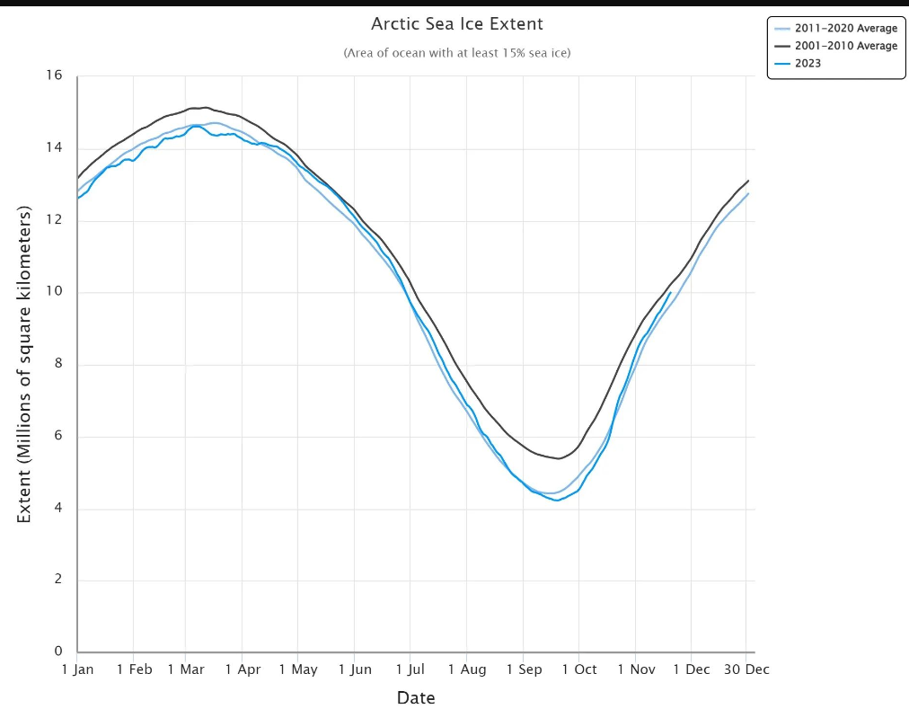
Chart: NSIDC
It’s clear to see that the Arctic sea ice extent is currently above the average for the period 2011-2020 and is rapidly approaching the average for the period 2001-2010. In fact, today’s extent of 10.019 million km² is higher than at the same time in 2009 when Gore made his prediction:
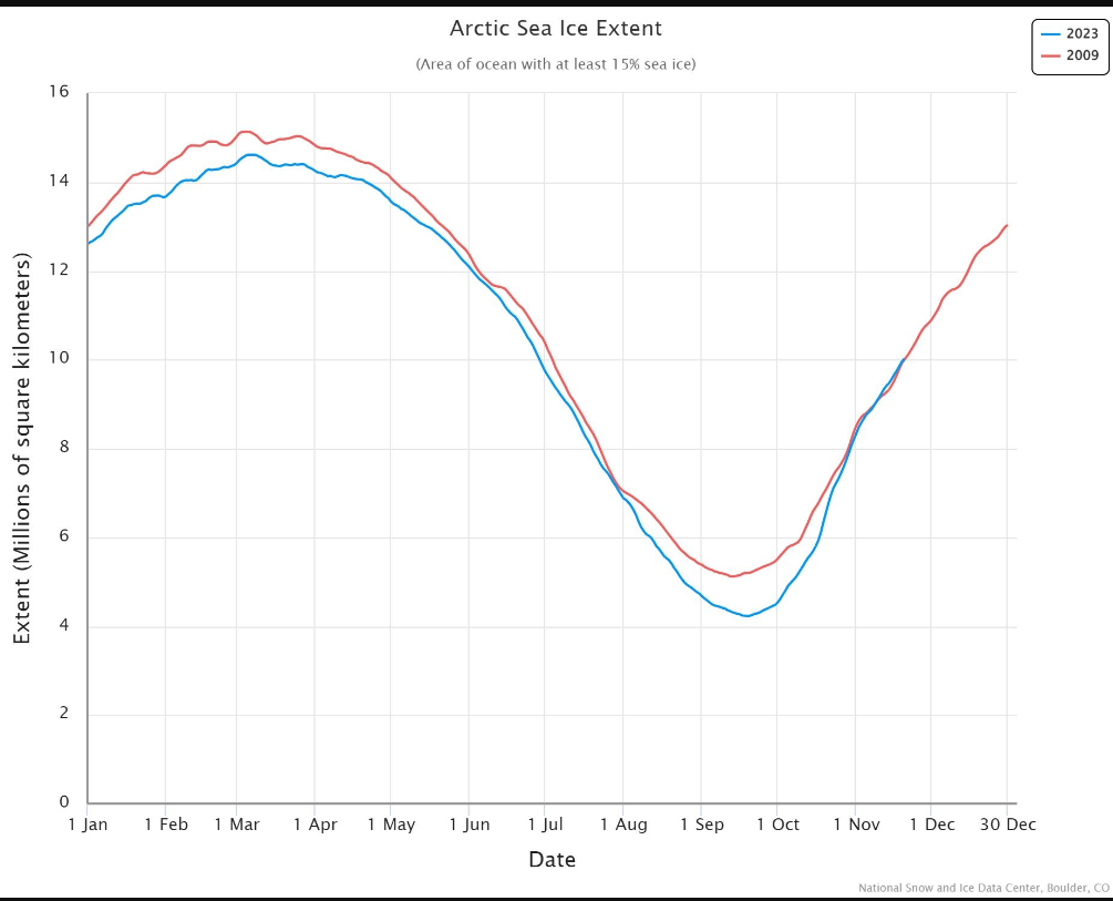
Chart: NSIDC
From polar bears to hurricanes, snowfall and climate-related deaths – all the theories of the climate alarmists are ultimately disproved by reality.
Climate charlatans like Gore and Gates can’t be wrong on so many issues for so long and still retain the platform they have without dubious media manipulation. The only reason the reputations of these public figures have not yet been dragged through the mud is because they 1) dutifully push the agenda and 2) believe everything printed in the legacy media.
Polar outbreaks in America, Europe imminent
The models appear to be fairly confident here: cold air of Arctic origin will affect both North America and Europe.
It’s getting colder in Brazil
According to the latest GFS runs, it will remain anomalously cold in Brazil over the next few weeks:
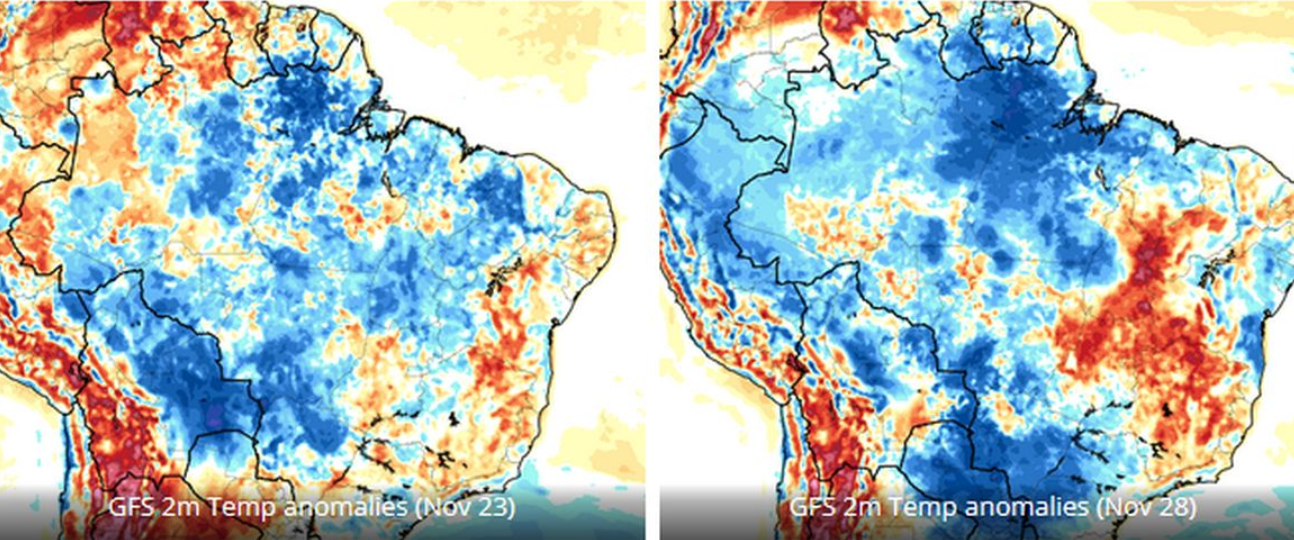
Chart: GFS
This is indicative of the longer-term cooling trend recorded by the country’s temperature stations.
The only weather station in Brazil with continuous data going back to 1900 is located in the eastern city of Quixeramobim in the state of Ceará, explains Tony Heller on X. According to NASA data, the temperature station in Quixeramobim shows a cooling since 1960.
Australian heat exaggerated
There is a lot of reporting about the heat and forest fires in Perth.
The exaggerations and propaganda are as captivating as the licking flames and swirling embers. But, as always, a quick fact-check destroys the scaremongering. A thin red spot [indicating heat] is not proof of a “climate crisis”:
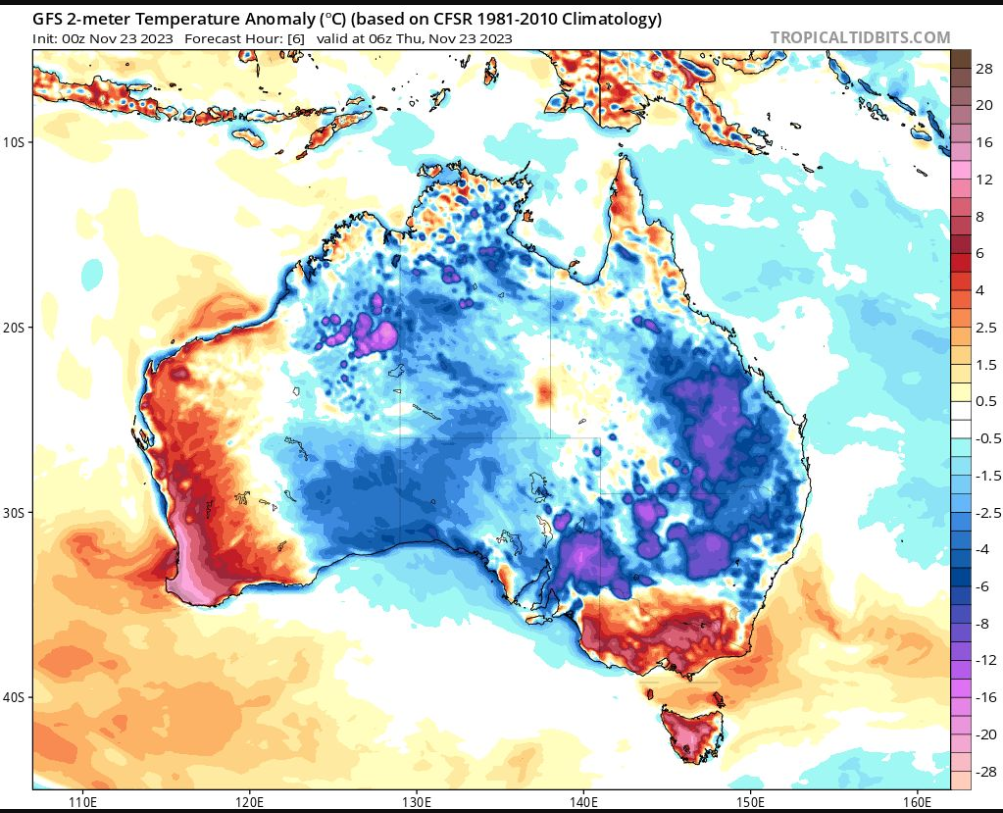
Chart: Tropical Tidbits
According to the satellite data, there’s been a cooling trend of -0.13 °C per decade since 2013.
Heavy snowfall in Eastern Europe, much more expected
After three days of snowfall, the Russian Volga region was buried under 30 cm of snow – an unusually high amount for November.
The November norm for the city of Ulyanovsk, for example, is 8 cm, but a week before the end of the month, 24 cm of snow had already been measured.
Winter a month early
In Izhevsk, the capital of the Republic of Udmurtia, the snow drifts are also “a month ahead of the calendar”, reports gismeteo.ru.
Further west, Belarus has declared the danger level “orange”, as heavy snowfall is forecast over the Norwegian Sea. On November 23, strong winds and snowstorms hit most of the country. Icy roads were reported in the western regions, as well as in the capital Minsk.
Northern hemisphere snow cover trends up
These snow amounts will contribute to another above average snow season for the Northern Hemisphere:
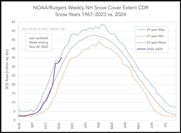
Chart: Rutgers
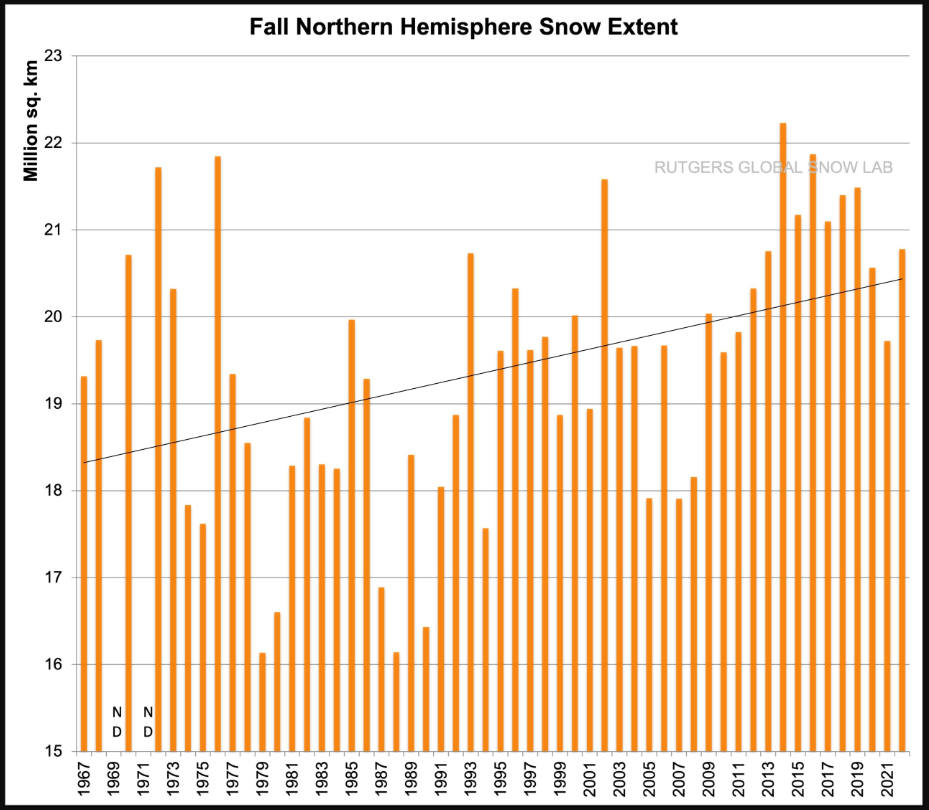
Chart: Rutgers
Editorial deadline for this report: November 24, 2023. Compiled by Christian Freuer for EIKE.
Main source: Electroverse.


[…] No Trick Zone […]
Snow belt from Cleveland to Buffalo got a load of Lake-Effect Snow.
Wasn’t Richard Greene mocking Bastardi for forecasting cold this winter?
Looks like Joe might have been correct after all?
https://www.thegatewaypundit.com/2023/11/global-warming-alert-german-authorities-urge-citizens-stay/
The Fall snowfall chart is disinformation
There is snow cover in the Fall, Winter and Spring, with the most snow in the winter for the Nothern Hemisphere.
Annual snow extent from the Same Rutgers snow Lab shows NO DOWNTREND, contradicting the Fall snow extent chart shown in this article.
An honest chart, available at the link below, shows the 12 month running mean through 2022 snow extent, not just the deceptive Fall snow extent chart
https://climate.rutgers.Edu/snowcover/chart_anom.php?ui_set=0&ui_region=nhland&ui_month=1
It is cold somewhere EVRY winter.
I mocked Bastardo’s 2022 winter forecast
The 2023 / 2024 winter has not started yet
In 2022 / 2023, here is what happened last winter
The 2022–23 North American winter was an unusually warm winter for the east and an unusually cold winter for the west in North America, as it occurred across the continent from late 2022 to early 2023.
Half cold and half warm
So any forecast would have been half right.
Similar 2022 / 2023 actuals for Europe
In winter, much of Europe saw temperatures more than 1°C above average, although in northern Scandinavia and Iceland, temperatures were as
Concerning Bastardi’s 2023 winter forecast:
Before you start cheering for Bastardi’s winter forecast, how about waiting until the winter has started on December 21, 2023 — three weeks from today — and then wqit until it ends on March 19, 2024, BEFORE evaluating any prediction accuracy.?
And remember that winters are always unusually cold somewhere.
Bastardi articles at CFACT.com on climate are by far the worst articles at a website that features a lot of good articles. He thinks underseas volcanoes cause climate change with no data to back up his claim.
“ Half cold and half warm” – RG
….which is Bastardi’s forecast for the upcoming USA winter, and as I recall for last winter, only with a different distribution. I’ve rarely (if ever) seen a forecast of his that shows everywhere warm or everywhere cold. Accusing him of that is just silly. Here’s his last week’s post (as of my writing this his post for this week isn’t up yet)
https://www.weatherbell.com/video/the-satirday-summary-1?full
As to underwater volcanoes, he’s making a reasonable educated guess (he rightly calls it an hypothesis), unlike those who unequivocally say he’s wrong, based on their ignorance .At this point, we are still learning what’s down there, so until we get a lot more data, he’s scientifically more correct than they.
https://joannenova.com.au/2023/04/the-science-is-settled-but-we-just-found-19000-new-volcanoes/
“And remember that winters are always unusually cold somewhere.”
Just as summers are always unusually warm somewhere.
We’ll have to remember that when the scary stories appear again in summer.
[…] Increasing Cold, Snow Cast Doubt Over Claim Of Rapid Warming As North Freezes […]
Correcting a typo
The full year N.H. snow extent chart contradicts the uptrend shown in the deceptive Fall snow extent chart in the article.
All data are from the Rurgers Snow lab in the USA.
Showing only the Fall chart is data mining for propaganda purposes