 Way back in February, Global Weather Oscillations (GWO) veteran meteorologist David Dilley predicted that the 2017 Atlantic hurricane season would be “the most dangerous and costliest in 12 years for the United States.”
Photo: David Dilley, GWO
In the wake of Harvey, and with an eye on the now growing threat posed by Irma, that prediction is emerging to be spot on.
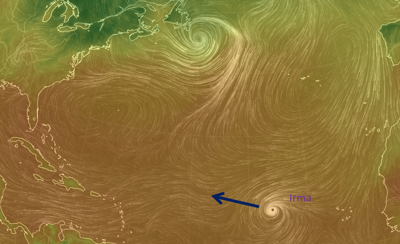
Irma takes aim. Chart source (1 Sept 2017 9:00 CET): earth.nullschool.net/.
Dilley, a 40-year veteran and a former NOAA meteorologist, said the season would be influenced by a Climate Pulse Hurricane Enhancement Cycle – which is characterized by the lack of El Niño or La Niña conditions. Recently the El Nino Southern Oscillation (ENSO) has been hovering near neutral territory.
Ideal oceanic conditions
Dilley based his February prediction on natural cyclic factors, namely on the fact that ocean water temperatures would “continue to run warmer than normal across most of the Atlantic Basin and especially in the Caribbean region and the Atlantic near the United States” this year, which would “make conditions conducive for tropical storms and/or hurricanes forming and/or strengthening close to the United States“.
So far that too has been spot on as well. This scenario has also been supported by Joe Bastardi of Weatherbell Analytics. Bastardi, also a 40-year veteran meteorologist, points to similarities with hurricane patterns of the mid 20th century.
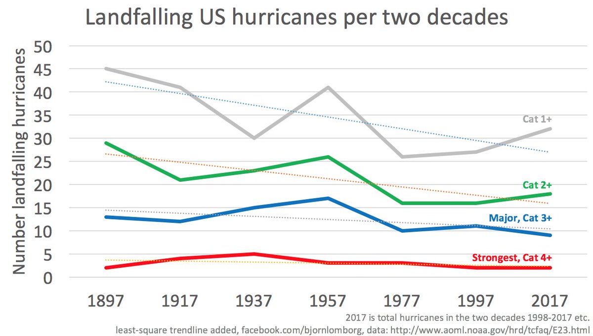
120-year trend clearly downward
Hurricane activity as a whole has been on a downward decline over the past 120 years, according to the NOAA – something that often gets no mention in the media.
Dilley also predicted that the Bermuda-Azores High Pressure Center would be weaker this summer, and thus would allow “more named storms to maintain strength – or strengthen as they move from east to west across the Atlantic toward the United States” – a pattern that Irma is following to a tee.
In his February forecast he wrote that the United States would have the potential for 6 named storms making landfall, the most most since 2005.
“Global warming has no influence”
In an e-mail response to NoTricksZone on whether hurricane Harvey’s intensity was related to global warming, Dilley wrote:
Global warming has no influence – we have had major impact hurricanes in the past when it was cooler – it is all cyclical.
Dilley also said that Harvey will with very high likelihood not be the last to strike the USA, saying that a number of hurricane zones need to prepare for the worst this season.
Perfect conditions for Irma
Concerning Irma the 40-year veteran meteorologist says that the hurricane “is in an area having perfect conditions” and that he expects “4 major hurricanes in 2017 due to a stronger hurricane cycle year that occurs in conjunction with warm Atlantic Ocean water following a period that did not have a La Niña – less wind shear and good positioning of the Bermuda high“.
Texas hurricane hiatus is over
Dilley had predicted that Texas had a “good shot at coming out of their quiet hurricane cycle” as -there have been 7 quiet periods for Texas during the past 130 years, writing that “the typical quiet period lasts 8 to 10 years and 2017 was year 9 since their last hurricane”.
Florida and New England are due as well
He warns that “other prediction zones such as the peninsula of Florida and New England are likewise on the verge of breaking out of their quiet periods” and that they are “all cyclical based on electromagnetism of the earth-moon-sun gravitational cycles influencing the Bermuda high, ocean temperatures via an El Niño or no El Niño and individual hurricane landfall cycles for each zone.” He sums up:
Bottom line – Irma will be a major United States impact hurricane and not the last land-falling hurricane of the season.”
2018 will be a quieter season?
One bright note: Dilley believes that the 2018 season will be less harsh, in part because of more favorable natural ocean cycle effects in the Pacific and Atlantic.
For Dilley, hurricanes are part of the natural weather and climate cycles and that it is something we’ll have to relearn getting used to. In the early 20th century things were much worse than what we’ve grown accustomed to seeing over the past decade.


[…] Read more at notrickszone.com […]
It sure looks right now like Irma is going to be a major that strike the US though it is far too early to tell. It blew up to a CAT III overnight.
Levi Cowan as usual is very conservative in his prognostications but Joe Bastardi as of this mornings daily update at Weatherbell.com shows Irma as a CAT IV at land fall and at this time he believes the most likely track is right up the eastern seaboard of the US.
As I said it is way to early to tell but Joe and his gang at weatherbell have been correct more than once when projecting hurricane tracks days in advance.
Anyway be ready for another mountain of ambulance chasing climate change crap from the alarmist camp. They don’t have the stones to forecast in real time extreme weather events but once they happen they always are there to try and advance their agenda on top of the death, suffering, and destruction left behind.
I’ve noticed that the alarmists aren’t so keen talking about the Arctic this summer.
Why? The Arctic is neither colder than last year nor is the ice extent any different. Hmm …
Greenland has been cooling since 2005, just as the North Atlantic has been cooling since about 2005, and the ice sheet has gained mass in 2016-2017:
https://notrickszone.com/wp-content/uploads/2017/08/Greenland-Ice-Sheet-2017-Mass-Gain.jpg
The Arctic is no warmer now than in the 1930s and 1940s…despite humans emitting 9 GtC/yr in recent years vs. just 1 GtC/yr for during the 1930s and 1940s.
Why did the Arctic cool down by about 1.5 C from 1940 to 1990 during the same time that human emissions exploded?
Ice volume has increased.
http://ocean.dmi.dk/arctic/icethickness/thk.uk.php
And so has the SMB of the Greenland Ice sheet.
http://www.dmi.dk/en/groenland/maalinger/greenland-ice-sheet-surface-mass-budget/
Seb, any other questions?
Wait until Sept 23rdor 24th when the new data on multiyear ice comes out. There is going to be a big jump and that will really drive them nuts.
P Gosselin,
Exactly! The loss of half an ice-cube of ice at the Arctic and all the usual big mouth climate eejits are in the papers and on the MSM news, screeching and barking their usual nonsense about loss of the Arctic ice as if it were meaningful. It is not and never has been, it’s just a distraction that the AGW advocates mindlessly witter on about because the high priest Hansen said it is important. IT IS NOT IMPORTANT!
Now that Greenland has gain in ice or that the Arctic is not on a ‘death spiral’ (remember that §Ð*©ing baloney?) all the MSM is very, very quiet.
So, it is highly probable that before the next summer melt season arrives a few storms shall hit the region, the wind will blow this floating ice mass around making it look ¼km² smaller, and all the AGW eejits will noisily go off again, like a raucous faulty car alarm, saying its all melted when it hasn’t.
My hope is that it all melts as we stay in a new modern warm period similar to the MWP that has gone before. I doubt that it will happen but you never know as these things are, by there very nature, unpredictable.
The models I’ve seen out of NOAA, and GFS have it heading to the Caribbean, so yes it will more than likely steer to the USA but maybe a while getting there. The hurricane is expected to be a category 4, or maybe higher, by Tuesday 5 September, however that is a long time into the future for a prediction of these things.
CAREFUL
My A.V. program (AVAST) says that the link in “Climate Pulse Hurricane Enhancement Cycle” is a “Reported Attack Page”
yonason,
Yes, got the same warning as someone has reported the redirection site ([http:][//]www.prweb.net/Redirect.aspx?id=aHR0cDovL3d3dy5nbG9iYWx3ZWF0aGVyb3NjaWxsYXRpb25zLmNvbS8jIWh1cnJpY2FuZS1zZWFzb24td2Vhay1vci1zdHJvbmcvYzE0ODI=
–my square brackets to prevent WordPress auto linking)
Using a temporary virtual PC network on a virtualized PC desktop on redundant hardware, I find that the site it points to is — http://www.globalweatheroscillations.com/hurricane-season-weak-or-strong , which appears to be safe.
Maybe just a false positive, which I’d rather have than a real one that my AV misses.
The link you provide works fine.
Thanks.
“Maybe just a false positive, which I’d rather have than a real one …”
Agreed and note that prweb site is nothing more than a publicity site (client news aggregator, public relations, PR admin, etc, etc…), so probably gets a few hits from rivals. As Gavin knows the PR game is never clean.
Model plot of Irma
http://my.sfwmd.gov/sfwmd/common/images/weather/plots/storm_11.gif
http://flhurricane.com/
@clipe
Any idea how good these models have been at predicting hurricane paths as they really haven’t had that much to look at for the last 12years.
Hi tomOmasom,
My impression, from visiting flhurricane over the years, is the models are doing long range weather forecasts.
Note the in the model plot gif, National Hurricane Center (NHC) stops at 5 days.
http://flhurricane.com/cyclone/showflat.php?Cat=0&Number=98005&page=2&fpart=all&vc=1&nt=2
Thank clipe,
I see from the link that some people are showing the same ECMWF forecast I have seen (but failed to bookmark). Still below is a short range forecast from them.
Nice link, clipe. Thank you.
@clipe
Here’s a run from ECMWF general forecast view,
https://www.tropicaltidbits.com/analysis/models/?model=ecmwf®ion=atl&pkg=mslpaNorm
Looks like Nova Scotia might be in for a walloping. A bit more than 5 days out of course.
http://flhurricane.com/modelanimator.php?storm=11&year=2017&title=11
http://weather.gc.ca/hurricane/track_e.html
clipe,
Nice links.
It’s always fun to watch these models change tack as the storms progresses. Looks like these models run on codified guestimation most times.
I hope everyone there is hurricane ready as there’s there’s likely to be another 2 on the way.
Last month I guestimated 3 for the USA and 4-5 for the Caribbean region, just going by the SST off the coast of Africa and no El Nino. Boy, I hope I’m wrong hurricanes are never nice.
When those storms head out towards Europe the weather models have a fit trying to guess what will happen. Old Caribbean tropical storms/hurricanes really spook them. 🙂
I have nothing to back this up, but I predict Irma will recurve before making US landfall.
Nova Scotia will get a brush-back pitch.
I have nothing to back this up, but I predict Irma will recurve
before making US landfall.Levi at https://www.tropicaltidbits.com/
explains why recurve off into the Atlantic is unlikely. At least for now.
CO2 and green house gas warming of the planet, is the teaching that the refractive insulation stopping 20% of otherwise available warming firelight from the sun, is making sensors on earth detect and depict ever more light warming Earth, as that very same insulation makes ever less light reach, and warm Earth.
It is a scam from the v.e.r.y. first s.y.l.l.a.b.l.e.
There is no such thing as insulation mixed into baths conduction-chilling sun-warmed rocks causing energy sensors on those rocks to detect and depict more light warming the less-and-less light-warmed rock with every percent less warming light, reaching that rock to warm it.
That is called ”Violation of Conservation of Energy.” Not maybe, not sometimes, that’s what it is.
No matter how many ignorant bloggers pretend otherwise, that’s a crass, shameless violation of the fundamentals of all thermodynamics.
Anyone who says otherwise can simply show us all, an instance when refractive light blocking insulation, placed between light from a fire and a sensor, made that sensor depict ever more light from the fire warming it as the insulation makes ever less light from the fire warm it.
I find it very interesting that the most commonly outspoken skeptics of the main tenets of AGW are engineers and those who routinely refer to the violation of the laws of thermodynamics. Just 1 of every 3 engineers and geoscientists are “consensus” believers.
Gerlich and Tscheuschner
https://arxiv.org/pdf/0707.1161.pdf
Falsification Of The Atmospheric CO2 Greenhouse Effect Within The Frame Of Physics
The atmospheric greenhouse effect, an idea that many authors trace back to the traditional works of Fourier (1824), Tyndall (1861), and Arrhenius (1896), and which is still supported in global climatology, essentially describes a fictitious mechanism, in which a planetary atmosphere acts as a heat pump driven by an environment that is radiatively interacting with but radiatively equilibrated to the atmospheric system. According to the second law of thermodynamics such a planetary machine can never exist. Nevertheless, in almost all texts of global climatology and in a widespread secondary literature it is taken for granted that such mechanism is real and stands on a firm scientific foundation. In this paper the popular conjecture is analyzed and the underlying physical principles are clarified. By showing that (a) there are no common physical laws between the warming phenomenon in glass houses and the fictitious atmospheric greenhouse effects, (b) there are no calculations to determine an average surface temperature of a planet, (c) the frequently mentioned difference of 33 ◦C is a meaningless number calculated wrongly, (d) the formulas of cavity radiation are used inappropriately, (e) the assumption of a radiative balance is unphysical, (f) thermal conductivity and friction must not be set to zero, the atmospheric greenhouse conjecture is falsified.
Why has Gerlich and Tscheuschner not been reference more by UN-IPCC? Because it runs against the pseudo-scientific claptrap and sophistry they offer.
Svante Arrhenius (1896), being a scientist at heart, realized that his original work was flawed and thus updated his views in 1906 (https://www.friendsofscience.org/assets/documents/Arrhenius%201906,%20final.pdf), and implied that others should investigate further to clarify the situation.
Comment in the spam bin?
http://www.meteoexploration.com/maproom/gfsmaps.php?lang=en&mvar=cldcovpcp&tstp=006®ion=AK#map
http://www.meteoexploration.com/maproom/gfsmaps.php?lang=en&mvar=wind&tstp=144®ion=AK#map
Oops! “Cloud Cover and precipitation”
Then “Wind speed and direction at 10m above the surface”
Irma
[…] P Gosselin, September 1, 2017 in […]
Joe Bastardi at Weatherbell has put out a Sunday edition of his “Daily Update” just about Irma. I can’t remember him ever doing that before.
Surface accumulated precipitation since t=0 [mm]
http://www.meteoexploration.com/maproom/gfsmaps.php?lang=en&mvar=sumprecip&tstp=105®ion=AK#map
NHC starts at 30/1500Z
http://flhurricane.com/modelanimator.php?storm=11&year=2017&title=11
Levi Cowan has an update at https://www.tropicaltidbits.com/
Great analysis. Lots of information. Thanks, RAH.
Your welcome. Levi will start posting videos whenever the tropical storms start to pop during the hurricane season and always goes into great detail in his analysis. At the beginning of the season he will also post a long video giving his analysis of the coming season. Well worth keeping the link.
“Well worth keeping the link.” – RAH
It was a done save as soon as I watched it.
Good to see XTRP becoming more due west. Still time to recurve.
http://flhurricane.com/images/2017/storm11//plot20170904-2044.gif
SUMMARY OF 800 PM AST…0000 UTC…INFORMATION
———————————————-
LOCATION…16.7N 55.0W
ABOUT 450 MI…725 KM E OF THE LEEWARD ISLANDS
MAXIMUM SUSTAINED WINDS…140 MPH…220 KM/H
PRESENT MOVEMENT…W OR 270 DEGREES AT 13 MPH…20 KM/H
MINIMUM CENTRAL PRESSURE…943 MB…27.85 INCHES
Oops! I didn’t mean to shout.
http://flhurricane.com/imageanimator.php?295
Try to keep an eye on xtrp.
http://flhurricane.com/modelanimator.php?storm=11&year=2017&title=11
Correction: Hurricanes NOT trending downwards.
Only CONTINENTAL USA hurricanes seem to trend downwards, but such a choice of date is equivalent to cherry picking: USA landing storms and hurricanes are only 25% of the total.
If you want to discredit “global warming” you need a global theory, you have to account for all hurricanes generated in the Atlantic, as global warming does not care about USA borders.
Unluckily this number is trending UPWARDS, so your theory needs to be revised.
Source: NOAA
http://www.aoml.noaa.gov/hrd/tcfaq/NS.jpg
http://www.aoml.noaa.gov/hrd/tcfaq/E11.html
Since when?
Northern Hemisphere
Chang et al., 2016
http://onlinelibrary.wiley.com/doi/10.1002/2016GL068172/abstract
Extratropical cyclones cause much of the high impact weather over the mid-latitudes. With increasing greenhouse gases, enhanced high-latitude warming will lead to weaker cyclone activity. Here we show that between 1979 and 2014, the number of strong cyclones in Northern Hemisphere in summer has decreased at a rate of 4% per decade
–
Western North Pacific
Choi et al., 2017
http://onlinelibrary.wiley.com/doi/10.1002/joc.5090/full
This study analysed the time series of tropical cyclone (TC) frequency during October–December (OND) for 32 years (1980–2011). There was a strong decreasing trend of TCs until recently, and the TC sharply decreased from 1996 after the statistical change-point analysis was applied to this time series.
–
Eurasia
Chen et al., 2017
http://journals.ametsoc.org/doi/full/10.1175/JCLI-D-16-0155.1
Results indicate that the midlatitude summer cyclone activity over East Asia exhibits decadal changes in the period of 1979–2013 and is significantly weakened after early 1990s. … Moreover, there is a close linkage between the weakening of cyclonic activity after the early 1990s and the nonuniform surface warming of the Eurasian continent. Significant warming to the west of Mongolia tends to weaken the north–south temperature gradient and the atmospheric baroclinicity to its south and eventually can lead to weakening of the midlatitude cyclone activity over East Asia.
–
Southeast Asia
Williams et al., 2016
http://www.sciencedirect.com/science/article/pii/S0025322715300876
Bayesian age–depth models, derived from eight AMS radiocarbon dates, suggest that the frequency of typhoon strikes was 2–5 times greater from 3900 to 7800 cal. yr. BP compared to 0–3900 cal. yr. BP.
–
Carribbean
Chenoweth and Divine, 2008
http://onlinelibrary.wiley.com/doi/10.1002/joc.5090/full
Our record of tropical cyclone activity reveals no significant trends in the total number of tropical cyclones (tropical storms and hurricanes) in the best sampled regions for the past 318 years. However, the total number of hurricanes in the 20th century is ∼20% lower than in previous centuries.
–
South China Sea
Ha and Zhong, 2015
http://journals.ametsoc.org/doi/abs/10.1175/JCLI-D-14-00769.1?af=R
This study investigates the decadal change in tropical cyclone (TC) activity over the South China Sea (SCS) in the boreal summer (June-August) since the early 1990s and explores possible causes behind it. Results show that the SCS TC [South China Sea tropical cyclone] activity experienced an abrupt decadal decrease at around 2002/2003. Compared to the TC activities from the early 1990s to 2002, the number of TCs formed in the SCS markedly decreased from 2003 through the early 2010s.
If up is down, then L.D.P. is correct that hurricanes are getting more powerful and more frequent. Otherwise, no.
http://policlimate.com/tropical/global_major_freq.png
http://flhurricane.com/sbanimator.php?year=2017&storm=11