Recall how man-made CO2 emissions are supposed to cause a greenhouse effect in the troposphere, meaning the stratosphere above it is supposed to cool. Lately, that has not been the case at all – at least over the northern hemisphere, 65°N and above, over the better part of the last year.
Schneefan here writes on an interesting phenomenon now taking place in the Arctic stratosphere. Much of what follows is a translation, along with some points I’ve added myself.
The upper stratosphere over the Arctic, her writes, has never been so warm in March since satellite records began back in 1979: a sudden stratospheric warming (SSW) with an expected splitting of the polar vortex is underway (polar vortex split).
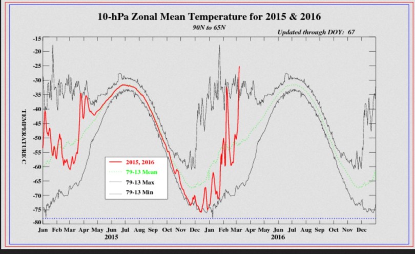
The plot above shows the sudden warming (red line) on March 7, 2016 (day 67 of the year) occurring in the upper stratosphere at 10 hPa (approx. 30 km altitude), between 65°N and 90°N. The red line significantly surpassed the high mark (upper black line) for March and is far above average (line with green dots). Source: www.cpc.ncep.noaa.gov/.
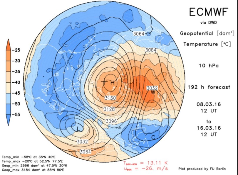
Through the strong warming and related pressure increase, a warm high has formed over the Arctic in place of the cold polar vortex. This means the polar vortex will split over the coming days and get displaced southwards – (polar vortex split):
ECMWF projection of March 8, 2016 for temperatures in the upper atmosphere at 10 hPa (approx. 30 km altitude) for March 16, 2016. The polar vortex has split due to the high pressure caused by the sudden stratospheric warming (SSW) over the pole. Two completely separated cold cores form over Siberia and Western Europe/North Atlantic. At this latitude the zonal wind has reversed from west to east. Source: http://www.geo.fu-berlin.html.
When there is a reversal in the temperature gradient and circulation (west wind shifts to east wind) from 60°N latitiude to the North Pole at in 10 hPa (approx. 30,000 m altitude), this is known as a major warming. Whether or not this ushers in a “final warming” and thus a switch from the Arctic winter to a summertime circulation remains to be seen…
The SSW and expected polar vortex splitting along with the reversal of zonal winds from west to east will also have major impacts on the circulation of air masses at the lower atmospheric levels of the northern hemisphere. The polar jet will meander and lead to enhanced exchange between polar and subtropical air masses: That means more cold air blasts into the middle latitudes are expected for the northern hemisphere.
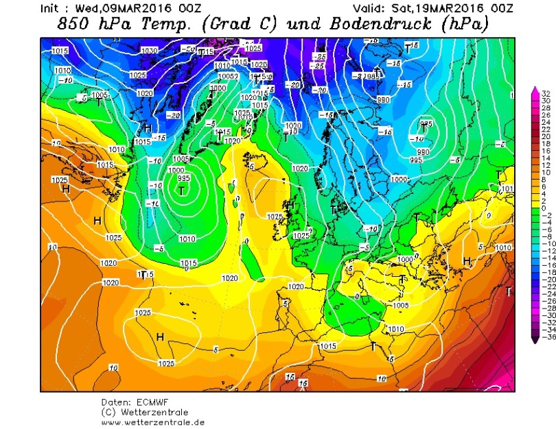
The ECMWF prognosis from 9 March 20016 consequently sees an intensified March winter 2016 over large parts of Europe. Wintry temperatures at 850 hPa (approx. 1500 m) of -10°C on March 19,2016 over eastern Europe:
ECMWF forecast of March 9, 2016, for temperatures on March 19, 2016, in Europe. Cold Siberian air is expected to flow across Europe between high pressure positioned over the North Atlantic and a low over Russia and southern Europe. Source: www.wetterzentrale.de/html
These unusually cold calculations have been more or less confirmed by other weather models over the past few days. But as everyone knows, forecasts 10 days out are fraught with considerable uncertainty, and so we should not lose hope for milder spring weather.
Yet, this year it looks like we’ll have to wait a little longer than normal. But that shouldn’t surprise us, though, because statistics show that spring has been arriving later and later in Europe over the past 2 decades – and not earlier.




That heat in the stratosphere & troposphere just indicates how much heat the Earth is losing to space in the Arctic area.
That suggests that we could see some quite drastic Ocean cooling soon.
In western France we have had cold springs for the last 5 years. We are expecting the next 10 days to be dry cool, rather than cold, with some grass frost.
In previous springs the months of mars, avril, mai have been colder than normal and wetter. The biggest problem has been drought from July to décembre.
97% Missing Heat Found!
It’s the “Zombies of the Stratosphere”!
https://www.youtube.com/watch?v=DYUS0qN1NFU
Martians are stealing our atmosphere!
This explanation is just as good as a post ad-hoc 97% Godzilla El Niño hiding the missing heat in the deep oceans, waiting to exact a horrible revenge on humans with climate justice for Gaia.
That extra heat in the stratosphere & troposphere is an indicator of how much heat is coming up from the tropics and being lost to space at the Arctic.
This suggests that the Oceans will be cooling off quite fast in the near future.
March so far was neither extremely cold nor extremely snowy. somewhat average, possibly a little colder than normal, but nothing serious.
Weather reports now speak of a sunny week with temperatures above 10°C.
http://www.wetter.de/cms/der-wettertrend-vom-12-03-2016-2779952.html
So if “sunny and rather dry” is how “intensified march winter” looks like, then so be it!
“The upper stratosphere over the Arctic, her writes, has never been so warm in March since satellite records began back in 1979: a sudden stratospheric warming (SSW) with an expected splitting of the polar vortex is underway (polar vortex split).”
What is happening in the Arctic is consistent with the thesis of Earl Happ that it is the Sun that drives the climate in “top down” mode via its effects on stratospheric ozone, the polar wind and geomagnetism that control surface pressure, clouds and winds to determine the amount and site of heat absorbed and emitted from the oceans,together via the formation of cyclones and anticyclones
that depend on the ozone content of the atmospheric cells in differing grid positions. His series of essays are a must for those who wish to understand our climate.
https://reality348.wordpress.com/
Thanks Peter azlac
you summed it up perfectly. I was being a tad coy.
A few have mentioned the heat transporting to the Poles and this is what we see in the stratosphere.
This is not the way I see it.
The heat is propagating downwards as explained by ECMWF UK NOAA etc. Check the various hPa or mb (heights) http://www.cpc.ncep.noaa.gov/products/stratosphere/temperature/index.shtml
And one can see that the heat or energy is coming from above! Not from underneath. Something else is heating up the stratosphere UP HIGH and dumping that load onto the arctic and at the same time it is pushing the cold polar winds equator-ward. What is heating up the stratosphere?
Check the 1hpa 2 hpa …..30hpa and so on. you can see the heat is being generated up in the upper stratosphere first.
Somebody help me out here. In the “Zonal Mean Temp” plot above, the red line (2015,2016) falls between the 79-13 max/min curves. So how is it “abnormal?” It looks like it’s happened previously, and to a much greater extent (max curve). Or did that happen in 2013 and 2014? And would that explain the BLISTERING cold in Indiana during the winter of 2013, and a slightly weaker repeat in 2014?
Or is it that little red spike going a little above the Max in March that we’re talking about? If that brief tiny blip can cause a major weather event, just how stable is the system?
“Or did that happen in 2013 and 2014? And would that explain the BLISTERING cold in Indiana during the winter of 2013, and a slightly weaker repeat in 2014?
Or is it that little red spike going a little above the Max in March that we’re talking about? If that brief tiny blip can cause a major weather event, just how stable is the system?”
Or could it be that you do not understand things at all?
Why would an arctic blip explain something in Indiana?
And the question is less about new records but aboutthe effect of having temperature differences of +20°C over extended periods of time. Those max line was formed over 30 years of data. In the cooling world you folks imagine, it should be extremely difficult to add a new max and we would mostly see new minimum numbers.
“Why would an arctic blip explain something in Indiana?” – SOD
For the same reason that it would explain “something” in Germany.
AnYbody ELSE?
“For the same reason that it would explain „something“ in Germany.”
That an event explains one thing, does not make it the explanation for something else.
We know taht there are huge changes in the arctic and we know that chnages to the polar vortex can cause periods of extreme cold pretty far to the south.
Yohanson,
the top dark line is the max temperature that was achieved for the 1979-2013 period. As is the lower dark line the minimum for the 1979 – 2013 period.
The red line is the current year. It shows that for the 8th of March period give or take a day or too that the polar temps at the 10mb range was a record. Without factoring in the 2014 or 2015 period.
@jopo
“the top dark line is the max temperature that was achieved for the 1979-2013 period. As is the lower dark line the minimum for the 1979 – 2013 period.
The red line is the current year.” – jobo
I know that.
“It shows that for the 8th of March period give or take a day or too that the polar temps at the 10mb range was a record.” – jobo
I know that as well. But note that it’s a whopping 4 degrees above the “max.” Now compare with the late Jan “max” that’s about another 7 degrees warmer. Did it cause problems anywhere in the world. If so, when and where? If not, why worry about March, which will now become incorporated into the new “max?”
It isn’t clear to me WHY that blip should be a problem. I’m not saying it isn’t, if a real weather wonk says it is. I’m just saying I don’t understand why. Your pointing out to me what I can already see for myself doesn’t clarify anything. But thanks for the effort.
@jopo (and Pierre as well)
One other thing.
“…30 hPa and 10 hPa (approx. 30 km) representing the middle stratosphere…”
http://www.cpc.ncep.noaa.gov/products/stratosphere/temperature/
It’s NOT the “upper stratosphere,” it’s the middle. What difference that makes, I don’t know, but there it is.
Yonason (not yohansen. my apologies)
1. That when following the energy transfer it starts from the top and works it way down. The energy does not come from below.
2. It is theorised that Suns EUV reaches our atmosphere Ozone production takes place via a process called photolysis. The extra ozone is added weight to the atmosphere. The extra weight in the atmosphere effects the geopotential height and this pressure differential between zones and thus the jet stream is born.
3. The QBO dictates whether this stratosphere ozone production will be a problem or not.
Please someone in the know correct me because this is what I am making out of it. I dont know if I have this 100% right.
@jopo
Thanks. That’s a little more like what I’m looking for. Bottom line, something is going on. I would just like to have some idea as to what a mechanism might be. If anyone has a link for that mechanism, it might be helpful to both of us.
One thing that bothers me is, how can we tell when there will be a problem by comparing a current year plot to a plot of max for all previous years? It seem like a sloppy way of testing for problems, unless all those max values represent years when we had similar occurrences, but even then, after adding more and more years, the method would become progressively less sensitive. And if a current year max exceeding previous didn’t always result in a problem, why not just throw dice?
Anyway, thanks again.
As to wrong name. No worries. It seems I misspelled your name above, as well. Sorry about that.
jobo13
Earl Happ explains his views in an article over at Paul Homewood’s site – Not A Lot of People Know That:
https://notalotofpeopleknowthat.wordpress.com/2016/03/13/the-role-of-ozone-in-the-earths-climate/
Thanks. Interesting material.
The long term trend until end of march is not speaking of any march winter. It might stay something colder than normal, but there wont be snow on Easter (which is really early this year!).
http://www.wetter.de/cms/der-wettertrend-vom-14-03-2016-2782177.html
[…] No Tricks Zone, by P […]