Ice and cold were supposed to be a thing of the past, global warming theorists insisted some years ago. But that hasn’t been true.
The problem is that the natural factors clearly dominate, and the experts had forgotten all about them. Winters with snow and ice are just as likely as they ever were in the northern hemisphere. This year could even get brutal.
Meteorological analyst wobleeibtdieerderwaermung here delivers his latest updated forecast for the European winter, borrowing from Weatherbell.com here and others.
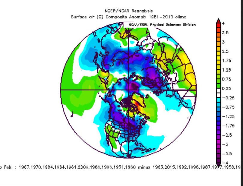
Forecast from 30 November 2016 for the northern hemisphere for December 2016 through February 2017. shows that the winter risks being an icy one for global warming infatuated Europe and USA.
Chances for white Central Europe Christmas above average
The Arctic polar vortex is expected to split in mid December and is forecast to usher in a larger wintery pattern, thus improving the chances for a snowy Christmas for Germany and Europe, the German site reports:
The stratospheric models form the ECMWF (Europe) and GFS (USA) today are in rare agreement with a dipolar of the polar vortex in mid December.”
ECMWF projected geopotentials at 150 hPa (approx. 14 km altitude, lower stratosphere) of 7 December 2016 for 17 December 2016. The vortex over Canada is the stronger of the two. A powerful cold trough of the polar vortex (Rossby waves) lies across Eastern Europe, pumping in very cold polar air. A powerful high extends from the Azores all the way to the North Pole (+). Source: www.geo.fu-berlin.de/met/html.
The following chart shows the GFS December 8, 850 hPa (ca. 1500m) forecast for the northern Hemisphere for December 19:
A major low pressure system centered over eastern and southern Europe could lead to a cold and moist polar air mass moving over Europe, leading to widespread snowfall. Source: http://old.wetterzentrale.de/topkarten/fsavneur.html.
The calculated change in the stratosphere will impact the general weather pattern in the underlying troposphere, with blocking highs over the eastern north Atlantic and lows over southern and eastern Europe. This would be the start of an intense winter weather pattern with widespread snowfall over large parts of Europe and Germany around December 19.
Temperature forecast for December 19:
Crystal-balling out to Christmas Eve
The GFS model forecast of December 8, 2016 shows an extensive low over southern Scandinavia pumping in cold moist air to Europe, which would bring widespread snow (see chart below). Source: http://old.wetterzentrale.de/html.
Of course readers have to keep in mind that these forecasts two weeks out are very speculative, and so it’s too early to place your bets. The patterns are unstable and it is impossible to predict where the cold polar air plunges will actually happen. Central Europe could get hit head-on, or we might luck out and get hit head-on by a southern warm air mass. Personally I prefer the cold snowy version for Christmas.
PS: The latest GFS model runs show seasonal temperatures for Central Europe in the days leading up to Christmas, with temperatures hovering around the freezing point.



At this time [10 Dec 12:52 pm CST] in Bismarck, North Dakota, a very central spot in North America, the temperature is -22°C [ -8° F]. We (central Washington State) are at the very western edge of this cold and have -7° C [19° F]. The pattern shifts from snow to cold as the air masses battle for possession of our area. Ski resorts are happy. Road travelers are finding difficulty staying on the roads.
The local weather forecasts seem to be good for about 6 hours.
It’s roughly central, East to West. But it’s longitude is 46.8, which makes it equivalent to Northern Maine. Also, if you look at the plant hardiness zone map, Bismark is also equivalent to N. Maine.
http://planthardiness.ars.usda.gov/PHZMWeb/#
The central states get cold first, because when the cold comes down from the North, that’s where it goes first, usually. And if you are in a Central Northern State, you get the brunt of the winter cold, always – so we don’t learn much from that about the weather in the rest of the States. FYI.
PS – Isn’t -8F for Central Washington unusually cold?
“-8F” is unusual; but not -8°C
At our location during the last 25 years the coldest has been -17°F.
The cold spell lasted 2 weeks. That’s at 2,200 feet elevation.
2,200 feet? Oh. Nevermind. :o)
Thanks
Pure nonsense. We’re supposed to believe that winds at 13.5 km height and 1/7th surface pressure “control” the much denser troposphere below? The “experts” have got cause and effect totally back-to-front. We’re told the jetstream “drives” the movement of weather systems in the lower troposphere. In fact, the jetstream simply takes the line of least resistance, between warmer systems, including high-pressure systems to the south, and colder, mainly low-pressure to the north. The weather systems control the track of the jetstream, not the other way around.
You can also employ a-causal relationships. If the weather has become really bad, you should after about two weeks vigorously pray for better weather. Usually, this helps. The other way around also works although it is seldom practiced (with the exception of Pierre) which consists of praying for a cold spell or a shock-freeze. For the same reason blood letting is followed often by a remarkable improvement of patients’ health. Blood letting of healthy patients should be avoided for moral reasons.
Tony Price 10. December 2016 at 11:30 PM | Permalink | Reply
“Pure nonsense. We’re supposed to believe that winds at 13.5 km height and 1/7th surface pressure “control” the much denser troposphere below? ”
Why not? The atmosphere is a chaotic system. *By the definition of Chaos* this means that small causes lead to large effects over time.
One would have to measure phenomena and examine their time lag to each other, do autocorrelation etc, and test for possible causality.
You know what a transistor is right? a small current controls a large current. This is the basis for an amplifier. To find computing circuits unaffected by EMP in the 60ies pneumatic circuits have been built and tested. Up to 100 kHz switching frequency were possible with a Y-shaped tube, with two control pipes from left and right, where a short pulse of air switched the main current from the left to the right leg of the Y. This then stayed stable. It was a pneumatic equivalent to a flipflop.
The Equatorial area is very large and that is where air goes up.
The stratosphere becomes involved.
The Polar area is small by comparison.
What goes up has to come down.
The rotating Earth and density play roles.
It gets complex.
Tony Price 10. December 2016,
Nice description for the consensus belief in static atmosphere.
With all those itemized by John F. Hultquist 11. December 2016 at 9:17 PM we can add in —
If only all those lower atmosphere global cells would stop wobbling around as they encircle the globe. If only the humidity in the cells would stay constant. If only the polar cell would stay in place and stay the same size. If only the upper atmosphere would stay in place and stop dynamically moving about (and react to solar effects, among many other things) causing the lower atmosphere to react to it. Also affecting how the jet stream and ozone layers slide about.
Yes, everything would be so much simpler if only the totality of atmosphere were less dynamic.
See Erl Happ’s excellent write up for a reasonable holistic explanation from observations of weather and climate, https://reality348.wordpress.com/
[…] Källa: https://notrickszone.com/2016/12/10/polar-split-threatens-to-shock-freeze-europe-this-winter/#sthash.… […]