UPDATE 4: See animation here.
UPDATE 3: Dr. Roy Spencer thinks Miami may have averted disaster.
UPDATE 2: Euro model shows Irma eye tracking along Florida west coast. The NAM model showing eye moving along OFF west coast.
UPDATE 1: Levi Cowan of Tropical Tidbits reports at Twitter that the forecast path has shifted westward, something he calls “some good news for the Miami area”. Let’s hope for more positive developments.
====================================
All the models agree that Irma will almost certainly hit Florida directly and that it would take a miracle to divert the storm away. It’s going to hit.
A number of factors could have prevented Irma from reaching the proportions and magnitudes that it has grown to, but unfortunately luck has played against Floridians and others in the region.
The steering troughs from the High out in the Atlantic and the Low plunging down across the southeast USA could have directed the storm out to sea, if only they had been positioned just a few dozen miles differently.
Shearing could have been stronger and weakened the storm, or the storm might yet track closer to Cuba, causing it to weaken some. But that is all not to be, and this time the die came up snake eyes. Instead, all factors unfolded in total favor of Irma in almost every way possible. The result: a very powerful hurricane, one we don’t see very often.
Levi Cowan at Tropical Tidbits here explained late Thursday evening the factors driving the storm, and the likely path in the days ahead. It really couldn’t be worse and more unfortunate.
The damage is going to be great. Hurricane conditions could extend up into southern Georgia. High winds and storm surges will be widespread along all coastlines on both sides of the Florida peninsula where many metropolitan areas happen to be sitting.
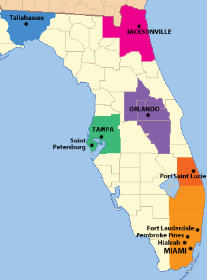
Map as per 2010 US Census showing cities with a population greater than 150,000, and their respective metro areas. Image by: CC BY-SA 3.0
Damage per square mile
Florida’s area is some 65,700 square miles and has a population of nearly 19 million, most of whom living in coastal areas. Property and infrastructure are naturally concentrated there and thus the state’s metropolitan areas will see tens of millions of dollars in damage per square mile, with some places possibly seeing damages in the hundreds of millions per square mile. Like Houston did.
Especially the areas along the coast, with their ports, harbors, high-rises, transportation facilities and extensive infrastructure, will see severe damage from high winds and storm surges. Rural areas of course will see less damage per square mile.
If half (conservative) of Florida’s area (32,000 sq mi) gets hit hard by surge and/or wind conditions with an average damage of $20 million per square mile (rough estimate), then we are looking at a potential of more than $600 billion in damage for Florida alone.
Now add the damage already done in the Caribbean, plus what will happen in Georgia and beyond. We are getting close to the astronomical sum of a trillion dollars.
There is still some time to get property out of harm’s way, but it’s just about run out. Residents need to focus on getting the hell out of the way and saving their lives.
Expect hysterical and irrational demands
Expect global warming alarmists to seize on the final damage tally, no matter what it turns out to be. They’ll be hysterical, and will irrationally demand that leaders implement multi-trillion dollar “climate protection” measures mostly aimed at reducing greenhouse gases, especially CO2 emissions from burning fossil fuels.
The problem with these measures, however, is that there is no evidence that they would have any impact on future hurricanes – none! Hurricanes have always occurred, and always will no matter how ecologically pious we may become.
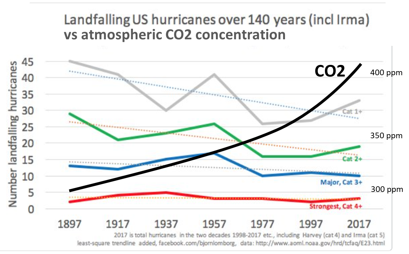
In fact a look at the past shows that hurricane activity trends have been decreasing over the past 140 years while CO2 emissions rose:
Hurricane activity has been falling over the past 140 years. CO2 curve added by NoTricksZone (not necessarily to scale).
If climate and hurricanes are indeed related to CO2, as alarmist and activist scientists insist, then the data are telling us to emit more and not less. Of course the CO2-hurricane-activity-relationship is silly, and is no solution.
Complacency after 12 years of low activity
The best advice here would be to invest the money into better infrastructure and more sensible urban planning. That lesson was learned long ago, but obviously got forgotten along the way.
Twelve years of no major hurricane strikes and decreasing activity likely led to just a little too much complacency.



Irma is now (6:00 AM EST) forecast to make landfall as a Cat4, and weaken to a Cat2 or lower (no longer a “major” hurricane) by the time it arrives as far North as Tampa.
http://www.nhc.noaa.gov/refresh/graphics_at1+shtml/035421.shtml?cone#contents
http://www.myfoxhurricane.com/custom/storms/storm1_track.html
Hopefully that trend will continue, and, since I live in Florida, the weaker Irma becomes the more relieved I get.
That said, it looks like Miami is still going to get hit pretty hard – not as hard as with Andrew in 1992, but still pretty hard.
The next Hurricane is not far behind. Die weather radar map looks kind of similar to the one in The Day after Tomorrow … https://imgur.com/gallery/W1iGs
If alarmists will exploit this. As well as “skeptics” exploit a single year of more SMB in Greenland … Which was largely caused by a hurricane, wasn’t it?
Of course not “if” (damn autocorrect)
Are you talking about Jose? Right now forecasts have it meandering out in the middle of Atlantic. BTW, how active is the Pacific right now?
Right now the Pacific is quiet. Last summer (2016) I waited out three hurricanes in the Pacific before bringing a boat from Maui to the Pacific Northwest. Prior to that in 4 trips I only waited out 1 hurricane.
I know anecdotes are not the best data, but in my experience Pacific weather is getting more extreme.
ACE data over past 30 years tell us a story that is different from your “experience”.
Who cares about data, when dogmas are there to be followed? For citizen climate scientists like Dave, personal experience no matter how short trumps any scientific data.
For the rest of us, here’s a good take on the alarmist spin:
https://rclutz.wordpress.com/2017/09/07/co2-also-explains-fair-weather/
Your experience appears to be contradicted by the available scientific evidence. Below is just a very partial list.
Zhang et al., 2017
http://www.nature.com/articles/srep42310
“Based on continuous and coherent severe weather reports from over 500 manned stations, for the first time, this study shows a significant decreasing trend in severe weather occurrence across China during the past five decades. The total number of severe weather days that have either thunderstorm, hail and/or damaging wind decrease about 50% from 1961 to 2010.”
–
Chen et al., 2017
http://journals.ametsoc.org/doi/full/10.1175/JCLI-D-16-0155.1
“Significant warming to the west of Mongolia tends to weaken the north–south temperature gradient and the atmospheric baroclinicity to its south and eventually can lead to weakening of the midlatitude cyclone activity over East Asia.”
–
Dezileau et al., 2016
http://www.clim-past.net/12/1389/2016/
“Storms and tsunamis, which may seriously endanger human society, are amongst the most devastating marine catastrophes that can occur in coastal areas. Many such events are known and have been reported for the Mediterranean, a region where high-frequency occurrences of these extreme events coincides with some of the most densely populated coastal areas in the world. In a sediment core from the Mar Menor (SE Spain), we discovered eight coarse-grained layers which document marine incursions during periods of intense storm activity or tsunami events. Based on radiocarbon dating, these extreme events occurred around 5250, 4000, 3600, 3010, 2300, 1350, 650, and 80 years cal BP. No comparable events have been observed during the 20th and 21st centuries.”
–
Chang et al., 2016
http://onlinelibrary.wiley.com/doi/10.1002/2016GL068172/abstract
“Extratropical cyclones cause much of the high impact weather over the mid-latitudes. With increasing greenhouse gases, enhanced high-latitude warming will lead to weaker cyclone activity. Here we show that between 1979 and 2014, the number of strong cyclones in Northern Hemisphere in summer has decreased at a rate of 4% per decade, with even larger decrease found near northeastern North America.
–
Tozer et al., 2016
http://www.hydrol-earth-syst-sci.net/20/1703/2016/hess-20-1703-2016.pdf
“The reconstruction shows that significantly longer and more frequent wet and dry periods were experienced in the preinstrumental [19th century and earlier] compared to the instrumental period [20th, 21st centuries].”
–
Williams et al., 2016
http://www.sciencedirect.com/science/article/pii/S0025322715300876
“Bayesian age–depth models, derived from eight AMS radiocarbon dates, suggest that the frequency of typhoon strikes was 2–5 times greater from 3900 to 7800 cal. yr. BP compared to 0–3900 cal. yr. BP.”
–
Hoerling et al., 2016
http://journals.ametsoc.org/doi/abs/10.1175/JCLI-D-15-0441.1
[A]ppreciable 35-yr trends in heavy daily precipitation can occur in the absence of forcing, thereby limiting detection of the weak anthropogenic influence at regional scales. … Analysis of the seasonality in heavy daily precipitation trends supports physical arguments that their changes during 1979-2013 have been intimately linked to internal decadal ocean variability, and less to human-induced climate change.”
–
Pausata et al., 2016
http://www.sciencedirect.com/science/article/pii/S0012821X15007530
“[T]he past millennia have witnessed much larger precipitation changes than those seen in recent decades.”
–
van der Wiel et al., 2016
http://journals.ametsoc.org/doi/abs/10.1175/JCLI-D-16-0307.1
“[T]he observed record and historical model experiments were used to investigate changes in the recent past. In part because of large intrinsic variability, no evidence was found for changes in extreme precipitation attributable to climate change in the available observed record”
–
Cheng et al., 2016
http://journals.ametsoc.org/doi/abs/10.1175/JCLI-D-15-0260.1
“The results thus indicate that the net effect of climate change has made agricultural drought less likely and that the current severe impacts of drought on California’s agriculture have not been substantially caused by long-term climate changes.”
–
Guo et al., 2016
http://onlinelibrary.wiley.com/doi/10.1002/2015JD024465/abstract
“[T]he combined spatial-temporal variability of U.S. tornado occurrence has remained nearly constant since 1950.”
–
Ljungqvist et al., 2016
http://www.nature.com/nature/journal/v532/n7597/full/nature17418.html
https://www.sciencedaily.com/releases/2016/04/160406133628.htm
“[T]he intensification of the twentieth-century-mean hydroclimate anomalies in the simulations, as compared to previous centuries, is not supported by our new multi-proxy reconstruction. This finding suggests that much work remains before we can model hydroclimate variability accurately. … According to a new study, the Northern Hemisphere has experienced considerably larger variations in precipitation during the past twelve centuries than in the twentieth century.
I said it was anecdotal. But your quotes deal more with precipitation, not wind strengths, and nine about wind strengths deal with the North East Pacific.
Nice try though. And thanks for not using notricks links.
Yes, apparently your experiential anecdote overrides 15-20 scientific papers because there were only 9 wind strength papers. Here are some more. Maybe this will be enough to come close to challenging the robustness and gravity of your personal anecdote.
Perrie et al., 2010
“The impact of climate change is seen in slightly decreased intensities in landfalling cyclones.”
–
Klotzbach and Landsea, 2015
“[T]be global frequency of category 4 and 5 hurricanes has shown a small, insignificant downward trend [1990-2014].”
–
Zhang et al., 2012
“The various SST measures only have a weak influence on TMLGP [tropical cyclones making landfall, South China] intensities. Despite the long-term warming trend in SST in the WNP, no long-term trend is observed in either the frequency or intensities of TMLGP [tropical cyclones making landfall, South China].”
–
Landsea et al., 1996
“A long-term (five decade) downward trend continues to be evident primarily in the frequency of intense hurricanes. In addition, the mean maximum intensity (i.e., averaged over all cyclones in a season) has decreased, while the maximum intensity attained by the strongest hurricane each year has not shown a significant change.”
–
Hsu et al., 2014
“All of the counts, lifespans, and accumulated cyclone energy of the late-season typhoons during the 1995–2011 epoch decreased significantly, compared with typhoons that occurred during the 1979–94 epoch.”
–
Hoarau et al., 2012
“There has been no trend towards an increase in the number of categories 3–5 cyclones over the last 30 years.”
–
Wu et al., 2006
“[D]ata show a decrease in the proportion of category 4-5 typhoons from 18% to 8% between the two periods of 1977-1989 and 1990-2004 (Table 1; intensity estimates in terms of sustained maximum winds first became available in RSMC-Tokyo best track data in 1977).”
–
Chan and Liu, 2004
“No significant correlation was found between the typhoon activity parameters and local SST [during 1960-2003]. In other words, an increase in local SST [sea surface temperatures] does not lead to a significant change of the number of intense TCs [tropical cyclones] in the NWP, which is contrary to the results produced by many of the numerical climate models.”
–
Zarzycki, 2016
“Multi-member ensembles show that the overall number of TCs [tropical cyclones] generated by the model is reduced by 5-9% when allowing for two-way air-sea interactions. TC [tropical cyclones] intensity is greatly impacted; the strongest 1% of all TCs are 20-30 hPa (4-8 m s−1) weaker and the number of simulated Category 4 and 5 TCs [tropical cyclones] are reduced by 65% in slab ocean configurations. Reductions in [tropical cyclone] intensity are in line with published thermodynamic theory.”
–
Blake and Landsea, 2011
“[D]uring the 40-year period 1961-2000 both the number and intensity of landfalling U.S. hurricanes decreased sharply. Based on 1901-1960 statistics, the expected number of hurricanes and major hurricanes during the period 1961-2000 would have been 77 and 30, respectively. However, only 55 (or 71%) of the expected number of hurricanes struck the U.S. with only 19 major hurricanes (or 63% of that expected number).”
–
Sanchez and Cavazos, 2014
“[D]uring 1970−2010 … SST in the MDR [along Mexican coasts] showed a statistically significant increase of 0.57°C over the whole period, but the frequency of HUR4−5 [intense hurricanes, Category 4 and 5] did not show a significant trend, while the frequency of HUR1−5 [weak and intense hurricanes] significantly decreased (−0.95% yr−1).”
–
Free et al., 2004
“Long-term changes in the intensity of tropical cyclones are of considerable interest because of concern that greenhouse warming may increase storm damage. The PI [potential intensity of tropical cyclones] calculated using radiosonde data at 14 tropical island locations shows only small, statistically insignificant trends from 1980 to 1995 and from 1975 to 1995. … Between 1975 and 1980, however, while SSTs rose, PI [potential intensity] decreased, illustrating the hazards of predicting changes in hurricane intensity from projected SST changes alone.”
–
Nott and Hayne, 2001
“Our estimate of the frequency of such ‘super-cyclones’ [wind speeds in excess of 182 kilometers per hour] is an order of magnitude higher than that previously estimated. … [The Great Barrier Reef] experienced at least five such storms over the past 200 years, with the area now occupied by Cairns experiencing two super-cyclones between 1800 and 1870. The 20th century, however, was totally devoid of such [super-cyclone] storms, with only one such event (1899) since European settlement in the mid-nineteenth century.”
–
IPCC AR5 (2013) Working Group I, Chapter 2
“In summary, confidence in large scale changes in the intensity of extreme extratropical cyclones since 1900 is low”
In my “experience,” trolls have little or none of any value, and what they have is grossly misinterpreted by them.
Jose
http://flhurricane.com/sbanimator.php?year=2017&storm=12
Joe Bastardi in his morning update at Weatherbell.com is saying that Irma will strengthen before it strikes the keys and Florida mainland. To quote: “it could rival what happened in 1935”. The labor day hurricane of 1935 that struck the Florida Keys is said to have been the most intense hurricane to have struck the US.
He now has the track west of Miami.
Joe is good with about as good of track record as you will find in forecasting hurricane tracks and strengths.
So last night and early this morning the idea was it would be a CAT IV and Miami was in the crosshairs. Now, the European and NCEP model ensembles have it strengthening back to strong CAT V and tracking west of Miami.
Yep, now the National Hurricane Center is saying the same things as Joe did this morning. One thing people have a hard time realizing is just how big this storm and the damaging wind field is! On the projected path well over half the state of Florida will be experiencing hurricane force winds at the same time and it is projected to still be a CAT II when it is adjacent to Jacksonville so basically only the western tip of the pan handle may miss experiencing hurricane force winds. Because the storm is so big it will take many hours for it to pass and thus those winds will be persistent for hours on end. And again, going up the spin means that almost all of the state will experience wind reversal. The wind direction will shift about 180 degrees once the eye of the storm pass over or by a location. The debris blown one direction against sturdier objects will then be blown the opposite direction. This is going to very bad.
[…] Bad Luck: Monster Hurricane Irma Could Rack Up $1 Trillion In Damages! […]
It does not look good.
And after hurricane Jose is forecast to hit the east coast of the USA…
https://www.tropicaltidbits.com/analysis/models/?model=ecmwf®ion=atl&pkg=mslpaNorm
Just a reminder —
Even worse than the disaster that was hurricane Harvey is the number of scammers trying to make money from the awful events. As Krebs on security has it in Beware of Hurricane Harvey Relief Scams (at https://krebsonsecurity.com/2017/08/beware-of-hurricane-harvey-relief-scams/ ) if you wish to donate —
krebsonsecurity site includes links to these charity evaluation sites.
No doubt the scammers are readying themselves for the generous but misinformed to donate to them with the latest disasters.
Is there no depths to which soulless scammers will sink?