UPDATE 3: But NOAA keeps moving track further out to sea…
UPDATE 2: Joe Bastardi says Maria not hitting US “not a done deal”.
UPDATE 1: NOOOOOO! F?§#! …NOAA updates latest storm track…takes Maria even further out to sea…
========================================
A few days ago it looked as if the US coast could be hit by two large hurricanes: New England by Jose, and later the Southeast by Maria. Global warming activists and the haters of our modern industrial society were salivating.
For example on September 17, the Washington Post presented one model with Maria barreling straight into North Carolina.
After all, imagine all the wonderful media headlines proclaiming “unprecedented destruction and hurricane forces“. It would be a wonderful field day. With such destruction, how could Denier in Chief President Donald Trump possibly be able to dispute that man is the cause? The witch hunt for and purge of deniers could begin in earnest.
Wild 1933 hurricane year
Yet, reality shows us that hurricanes have always been just as violent and occurred just as often in the past, if not more often. For example, Ryan Maue here reminds us of the fury of 1933 season:

In that year, Maue tweeted, saw 15 of 20 storms hitting land “with 6 majors and 2 Cat 5’s“. Imagine if that were to happen today. This type of destruction is precisely what the global warming ambulance chasing media and fake scientists are hoping for today. so it is only natural that some days ago Jose and Maria showed signs those glory days maybe returning – possibly the chance of two hurricanes hitting the US at once!
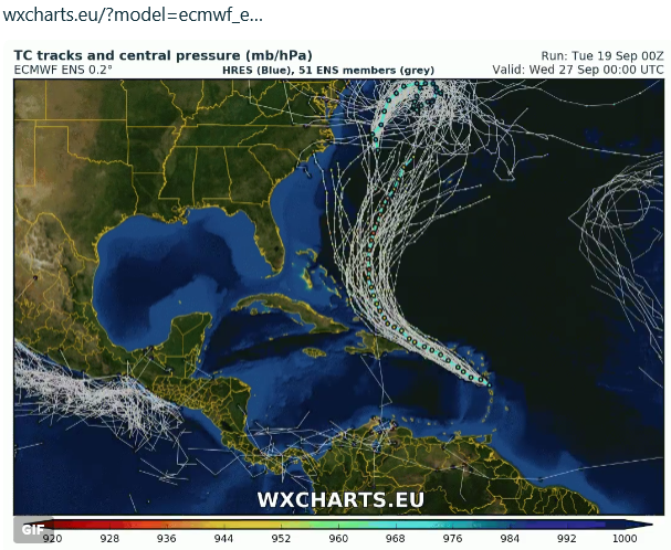
But now the most recent computer models show that Jose is in its death throes, stuck off the coast of New England, crumbling and no longer posing any serious danger. At Twitter the outstanding wxcharts here shows the latest tracks for Maria and Jose:
A storm that protects us?
At the top of the graphic above we see the remnants of Jose. Ironically hurricane Jose, which alarmists had hoped would smash violently into the Northeast, is turning out to be a possible savior in that it could play a key role in deflecting powerful Maria away from land. Just imagine: A global warming produced hurricanes that protect us!
As the chart above shows, Maria is projected to head out to sea, thus allowing us to be more hopeful. Yet it is still too early call off the alarms. There’s still some chance that Maria could veer off the model projected course and make landfall. Readers living on the East Coast must remain vigilant. Thankfully, most computation see the storm tracking out to sea.
Today at his Daily Update, Joe Bastardi cautions us and points out that Maria still has a considerable window to make landfall around North Carolina. Hurricane forecasts beyond 5 days Harbour tremendous uncertainty.
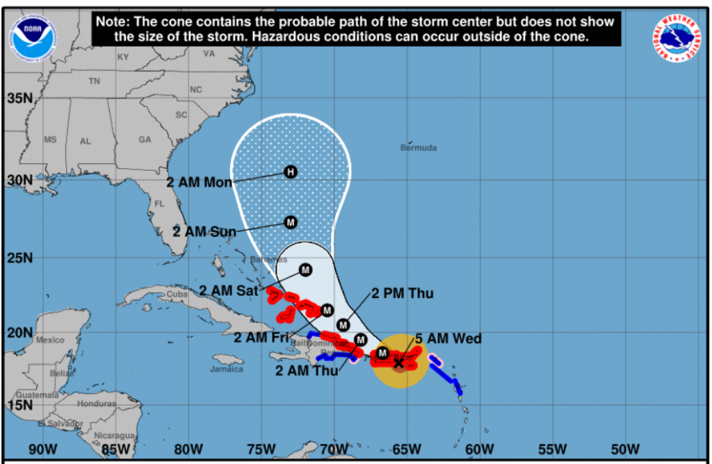
NOAA also has Maria headed out to sea with its latest cone:
Maria projected to head out to sea. Source: NOAA.
The profiteers of bad news
The media and climate ambulance chasers of course will deny that they are becoming disappointed by the latest tracks, and that people couldn’t be so mean as to wish deadly storms to strike land. But it’s not so. Much of the mainstream media are terrible people who are agenda-driven. They deceive their readers and try to manipulate public perception with fear. They make their livings with bad news. Bad news for them is good news. How often do you ever see them write about good news? How often do we see them present things on their bright side? They’re just nasty people.
But there is some good news out there for the media, climate ambulance chasers and mass destruction fantasists: the hurricane season still has a long way to go, and so they can hope for new hurricanes. It still remains an ideal year for hurricanes.


But will the alarmist comprehend and appreciate that a 12 year hurricane drought is fairly unusual, and will they realize that now the hurricane season is returning to normality.
No, they think there is an HTC (Hurricane Traffic Controller)who is driven by the concentration of one simple molecule?
PS whilst in recent modern history “a 12 year hurricane drought is fairly unusual” we really ain’t been around long enough to make any sort of call. The makings of hurricanes are there every year why there is no ‘standard year’ is still, and may fore ever be beyond our ken.
So expect and prepare for the worst so far experienced. Best you can do
Green Sand,
“…we really ain’t been around long enough to make any sort of call. “
Yep I agree, but for the usual alarmists 30 years appears to be far to long a period for them to think about.
Or as Dr. Roy Spencer graphically puts it —
https://wattsupwiththat.files.wordpress.com/2017/09/florida-major-hurricanes-3.jpg
Neither the number nor the intensity shows much of a trend.
Without going into details, it is Trump’s fault.
The ‘official’ hurricane numbers only run 166 years or so…
http://www.aoml.noaa.gov/hrd/tcfaq/E11.html
In a not unrelated note,
https://polarbearscience.com/2017/09/19/fabulous-polar-bear-science-book-for-kids-now-available-in-french-and-german/
Maria
http://flhurricane.com/modelanimator.php?storm=15&year=2017&title=15
Oh the horror!
Tropical Cyclone Information Statements8:46 PM ADT Wednesday 20 September 2017
Tropical cyclone information statement for:
Nova Scotia:
Queens County
Shelburne County
Yarmouth County
For Tropical Storm Jose.
The next information statement will be issued by 3:00 a.m. ADT.
Tropical Storm Jose is forecast to drift slowly well southwest of Nova Scotia for the next few days. Minimal land impacts are expected except for rough surf along the Atlantic coast of Nova Scotia.
1. Summary of basic information at 9:00 p.m. ADT.
Location: 39.5 North 68.6 West.
About 230 kilometres south-southeast of Nantucket.
Maximum sustained winds: 111 kilometres per hour.
Present movement: Northeast at 13 kilometres per hour.
Minimum central pressure: 976 millibars.
2. Public weather impacts and warnings summary.
Big picture:
Jose continues as a tropical storm and its circulation is still expected to just barely affect Nova Scotia while it drifts slowly well southwest of the province. It will take several days for Jose to dissipate completely.
Hurricane Maria, now a category 2 hurricane recently passed over Puerto Rico. That storm will be located near the Bahamas by the weekend, at which time we will be contemplating whether the Canadian Hurricane Centre will be issuing regular bulletins on it. Stay tuned.
a. Wind.
It's still looking like only light to moderate easterly winds will be felt in Nova Scotia on Wednesday and Thursday. Winds will be a bit stronger over southwestern parts of the province (~50 km/h).
b. Rainfall.
Jose and an associated trough east of it will maintain very humid, tropical air over the region with overcast skies. Conditions should start to dry out a bit on Thursday.
c. Surge/Waves.
Increasingly rough surf conditions can be expected along the Atlantic Coast of Nova Scotia tonight into Thursday. Swells near 2 to 3 metres will build to 3 to 4 metres along the Atlantic Coast of Nova Scotia tonight and into Thursday then taper off late Friday into the weekend. The highest waves are expected from Yarmouth east to Queens County. There is also a risk of dangerous rip currents during this period and the public should exercise caution near the beaches.
Tides will be high due to the new moon phase but no storm surge is expected. The combination of large waves and tides will lead to water running up fairly high along the shorelines but we are not expecting that to cause any issues.
3. Marine weather impacts and warnings summary.
Gale force east to southeast winds are expected for the southwestern portion of the Maritimes marine district tonight and Thursday. There is a small possibility that storm force winds could reach the far southern part of Georges Bank. Gale warnings have been issued for Georges Bank, Browns Bank and the southwestern half of West Scotian Slope.
Forecaster: Mercer/Hatt
Please continue to monitor alerts issued by the Canadian Hurricane Centre and forecasts issued by Environment Canada.
For more comprehensive information about track tables and forecast rationale, please see the Technical Discussion
Visit the Canadian Hurricane Centre to learn more about hurricanes.
What we are doing
Weather Forecasts
Canadian Weather
http://weather.gc.ca/hurricane/statements_e.html
Slightly off topic —
The active area of sunspots are just arriving back to face us
https://youtu.be/CqzE9eelfJY
Not off topic at all. Sunspots are an electrical phenomenon. Sunspots affect the Earth. All storms from thunderstorms to tornadoes to hurricanes are electrical phenomena caused by solar electrical influences. So-called modern science has not caught up with these facts yet.
I note your “UPDATE: NOOOOOO! F?§#! …NOAA updates latest storm track…takes it even further out to sea…”
The model’s codified guesswork is still running.
These models are as dynamic as the weather/climate they try to predict though not always accurate to reality.
(Same kind of encoded guessing has changed your “NOAA Models Project Harsh 2017/18 European Winter…Possibly Coldest This Century” (meteociel.fr link) to a cool to mild and wet scenario, and your El Nino/La Nina prediction in “As La Nina Looms, Warmists Skid Into Panic Mode…Global Warming Pause Set To Surpass Two Decades!” has also changed)
Nice to think that the same encoded guesswork methods (and worse) are used in the long term climate models, which is why they should NEVER be used to make policy.
12:05 CET 21/09/18
Stefan Rahmsdorf is on Phoenix TV and that the two cat 4 and two cat 5 hurricanes are unprecedented and that Irma with 300 km/h is the strongest ever and there has never been so much damage caused.
All as expected … higher surface sea temps… global warming… we’re all gonna die etc etc
Lying as usual.
https://twitter.com/philklotzbach/status/910847374938988545
[…] Jose And Maria Frustrate Global Warming Ambulance Chasers, Media And Warmunistas […]
It’s official! It’s now an official “Fish Storm”!