The onslaught of paleoclimate evidence for warmer-than-now Mid-Holocene climates – when the Earth’s sea levels were meters higher than they are today – stormed through 2019.
There were 107 scientific papers published this past year indicating today’s warmth isn’t even close to being unusual or unprecedented when compared to the climates of the last centuries to millennia.
As illustrated below, there were also 19 papers affirming today’s sea levels are among the lowest of the last ~8000 years.
This is added to the list of nearly 100 scientific papers published in the last handful of years indicating Mid-Holocene sea levels were multiple meters higher than they are today due to the much more extensive glacier and ice sheet melt occuring during these millennia.
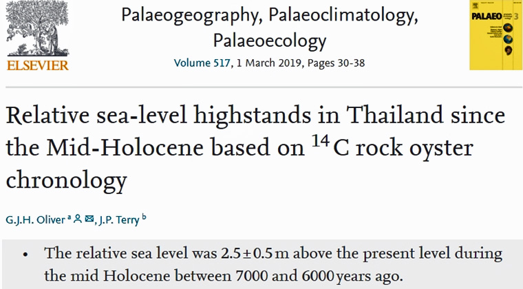
Oliver and Terry, 2019 Thailand, +2.0 to 3.8 m higher than present
“~6000 cal yr B.P. old oysters can be found from between 3.8 ± 0.1 m to 2.5 ± 0.1 m above present day mean sea level. … Dead (fossil) oysters were collected from between 1 and 3 m above the centre of the live oyster band in a more sheltered cleft inside the notch. The oldest sample with an age of 5270–4950 cal yr B.P. was collected at an elevation of 3.01 ± 0.1 m above the apex of the notch. The ages decrease with elevation down to 920–710 cal yr B.P. at 1.03 m. … In all the sites, the 14C age of the dead oysters inside the notches increases with increasing elevation above present day MSL. Clearly, relative sea level was 2 to 3 m higher than present between 6000 and 3000 B.P. and has steadily fallen since.”
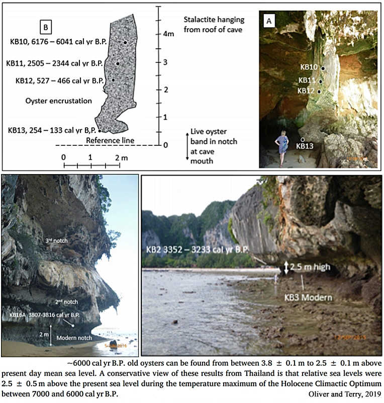
Brooke et al., 2019 Queensland (NE Australia), +1-2 m higher than present
“Indicator data for Queensland have been assessed for their accuracy and robustness by Lambeck et al. (2014), who identified a number of coastal and inner shelf island sites in the northeastern region, in which Cowley Beach is located (Fig. 1), where accurately dated in situ fossil coral, coral microatolls and sediment core samples provide robust sea-level records (Chappell, 1983; Chappell et al., 1983; Horton et al., 2007; Yu and Zhao, 2010; Zwartz, 1995; Fig. 3). Here, relative sea level reached a Holocene highstand between 6770 and 5520 yr BP approximately 1–2 m above the present level (Lewis et al., 2013; Fig. 3). Following the highstand, the data record a gradual fall in sea level to the present position (Perry and Smithers, 2011; Lambeck et al., 2014). … Local and regional records for the Holocene at far-field sites may also reflect the influence of climatic variations on sea level, such as shifts in the El Nino Southern Oscillation (ENSO), that can induce minor (<0.5 m) changes in sea level (Duke et al., 2017; Leonard et al., 2018; Sloss et al., 2018) on annual to multi-decadal, rather than millennial, timescales.”
Yamano et al., 2019 SW Japan, +1.1 to 1.2 m higher than present
“Evidence from the core samples and fossil microatolls suggests sea level reached its present position before 5100 cal yr B.P., and a relative sea-level highstand of 1.1–1.2 m above the present sea level occurred from 5100 to 3600 cal yr B.P. This was followed by a gradual fall in relative sea level. The tectonically corrected sea-level curve indicates a stable sea level after 5100 cal yr BP., with a sea-level highstand of up to 0.4 m between 5100 and 3600 cal yr B.P.”
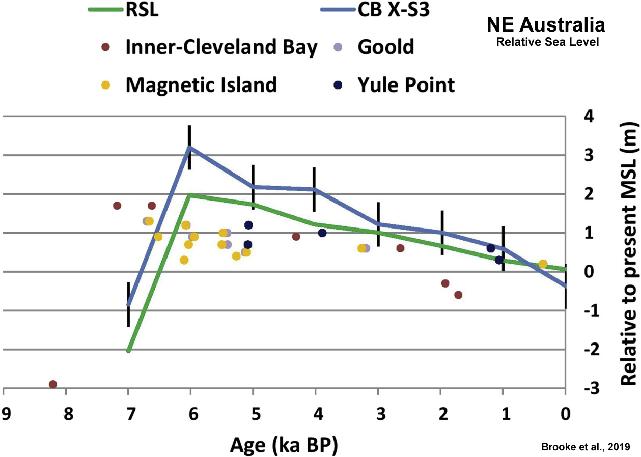
Makwana et al., 2019 Western India, +2 to 3 m higher than present
“The BB trench site is located at an elevation of 2 m above present day msl, where it shows evidences of dominant marine processes at depth of 2 m with a horizon of clay at depth of 3.2 m. In coastal environments, clayey horizons get deposited in calmer and non turbid conditions with depth > 3 m, which explains the clay horizon at BB trench site that would have been deposited with the water level depth of 3.2 m at > 2.5 ka period.”
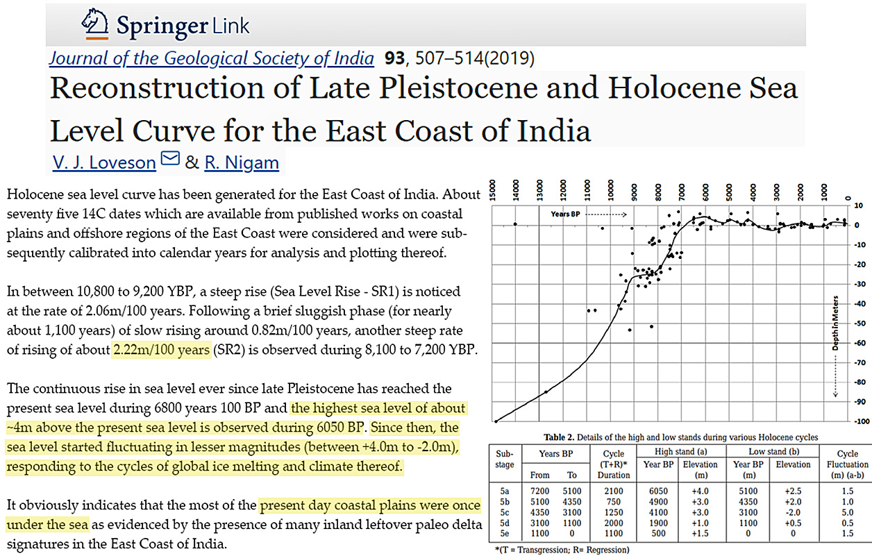
Loveson and Nigam, 2019 Eastern India, +4 m higher than present
“The continuous rise in sea level ever since late Pleistocene has reached the present sea level during 6800 years 100 BP and the highest sea level of about ~4m above the present sea level is observed during 6050 BP. Since then, the sea level started fluctuating in lesser magnitudes (between +4.0m to -2.0m), responding to the cycles of global ice melting and climate thereof. … It is also observed that the magnitude of all five high stands in between 7,200 to the recent has a decreasing trend from +4m to 0m. It obviously indicates that the most of the present day coastal plains were once under the sea as evidenced by the presence of many inland leftover paleo delta signatures in the East Coast of India.”
Oliver et al., 2019 South Australia, +2 m higher than present
“Raised beach strata imaged with Ground Penetrating Radar (GPR) at Rivoli Bay suggest a sea-level highstand of +2 m above present ~3500 years ago, steadily falling and reaching the present ~1000 years ago.”
Kylander et al., 2019 Scotland, +9 m higher than present
“At present, the Laphroaig bog is edged by a dune system, but this sand source may have looked very different at the time peat accumulation started 6670 cal. a BP. A primary control on dune building is RSL. Glacial isostatic modelling, supported by radiocarbon-dated sea-level index points, show that the RSL on Islay was about 9 m higher at 6000 cal. a BP, and fell in a linear fashion to 2.2 m higher than present at 2000–1000 cal. a BP (Fig. 7C;Dawsonet al. 1998; Shennan et al. 2006a,b).”
Meeder and Harlem, 2019 Southeast Florida (USA), +1-1.3 m higher than present
“Sea level was at ca 8 m above present during the last interglacial ca 120,000 yr bp inundating the entire platform during deposition of the Miami Limestone strata (Moore, 1982) … The marls form a leaky seal on the Everglades floor (Figure 14B) slowing water infiltration and storing water, increasing the hydroperiod and providing an environment suitable for peat deposition which started ca 4,500 yr bp (Gleason & Stone, 1994) at elevations between 1 and 1.3 m above present sea level (Wanless et al., 1994). … The historic high‐water stage occurred prior to drainage when the water stage was between 0.6 and 2 m higher than present in the study area (McVoy et al., 2011; Parker, 1975; Parker et al., 1955).”
Cuttler et al., 2019 Western Australia, +1-2 m higher than present
“Ningaloo Reef grew over the last ~8,000 years (Twiggs and Collins, 2010) with rapid reef build up ceasing ~5.8 ka BP when sea level was approximately 1 to 2 m higher than present. During this phase of development, benthic cover was dominated by reef-building corals (Collins et al., 2003; Twiggs and Collins, 2010). After this sea level highstand, reef evolution at Ningaloo was characterised as ‘detrital build-up and aggradational’ as sea level fell to present levels and the reef back-stepped (seaward) to its present location (Twiggs and Collins, 2010).”
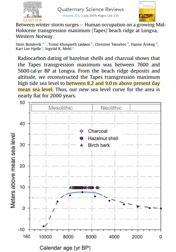
Bondevik et al., 2019 Western Norway, +8.2 to +9 m higher than present
“We conclude that the maximum sea level of the Tapes transgression lasted 2000 years from 7600 cal yr BP and extended into the Early Neolithic, to about 5600 cal yr BP (Fig. 13), with an uncertainty of about 100 years. We estimate that the highest spring tide during the Tapes transgression maximum phase was between 8.2 and 9.0 m above the present mean sea level. … To account for additional uncertainties, we suggest that the spring tide sea level at Longva would have been 8.6 ± 0.4 m above present day mean sea level during the Tapes transgression maximum.”
Yamada et al., 2019 Japan, +1 m higher than present
“Post-glacial sea level reached about 1 m higher than today around 6000 years ago and then started to fall (Yokoyama et al., 1996). As such, a sudden appearance and increase of marine and brackish diatoms just below PL-b cannot be explained by eustatic sea-level change.”
Montaggioni et al., 2019 French Polynesia, +0.8 m higher than present
“The foundations of islets (motus), namely conglomerate platforms, started to form with deposition of patchy, rubble spreads over the upper reef-rim surfaces from ca 4,500 yr BP as sea level was about 0.80 m above its present mean level. On these platforms, islets started to accrete not before ca 2,300 yr BP, from isolated depocentres located midway between outer-reef and lagoon margins. At that time, sea level at about +0.60 m above present mean sea level was starting to slowly decrease to its present position.”
Brouwers et al., 2019 Dubai, +1.6 to 2.5 m higher than present
“During Pleistocene glaciations, global sea level was 100–120 m below the present level and resulted in most of the Arabian Gulf occurring as a dry basin (Purser 1973; Gunatilaka 1986) … Since late Pleistocene to early Holocene times, the sea level rose gradually until a maximum sea level stand 1.6– 2.5 m higher than today (Gunatilaka 1986).”
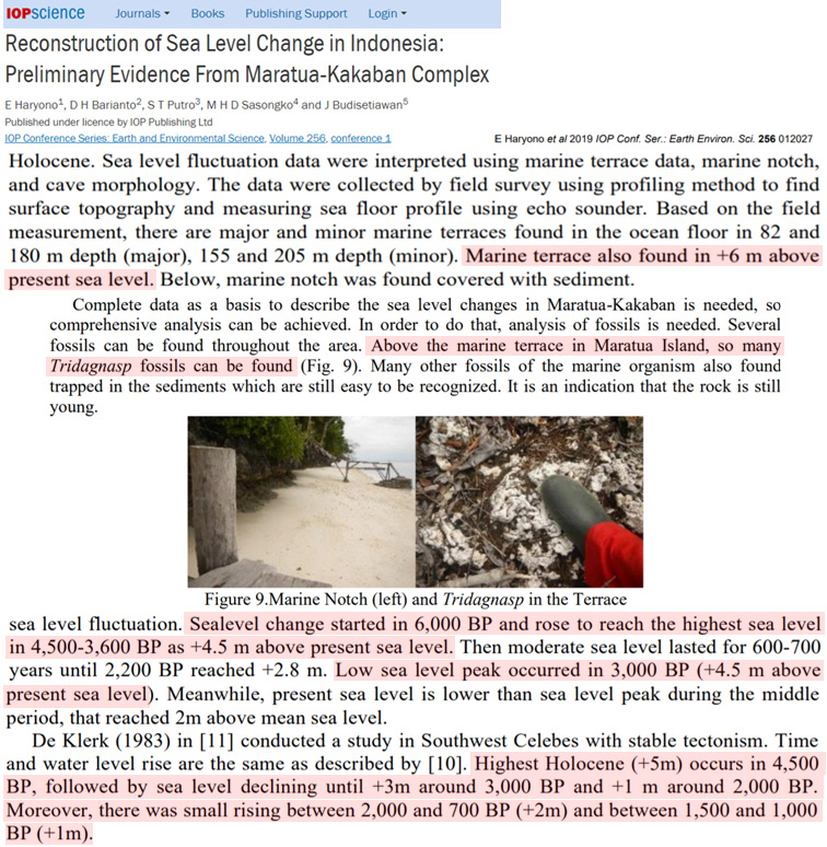
Haryono et al., 2019 Indonesia, +4.5 to 6 m higher than present
“[I]n 5000 BP, sea level increases up to +5 m from the present time; it means it was warmer than the present day. … Sealevel change started in 6,000 BP and rose to reach the highest sea level in 4,500-3,600 BP as +4.5 m above present sea level. Then moderate sea level lasted for 600-700 years until 2,200 BP reached +2.8 m. Low sea level peak occurred in 3,000 BP (+4.5 m above present sea level). Meanwhile, present sea level is lower than sea level peak during the middle period, that reached 2m above mean sea level. … Marine terrace also found in +6 m above present sea level.”
Williams et al., 2019 North Vietnam, +2 to 4 m higher than present
“A freshwater coastal marsh near the mouth of the Cam River in Northern Vietnam stands 2–3 m above mean sea level and is bordered by a coastal barrier that reaches about 6 m above mean sea level. A core from the marsh contains a 14-cm-thick sand and shell layer. The presence of abundant shell fragments suggests inland transport of littoral sediment, and the sand layer is tentatively identified as a washover deposit. The coast of the study area contains a beachrock standing above the modern beach and reaching to ∼4 m above mean sea level. A tentative explanation of this beachrock is that it represents a beach that formed during a mid-Holocene 2–3-m highstand, evidence for which has been reported from Thailand, Malaysia, Singapore, and Vietnam.”
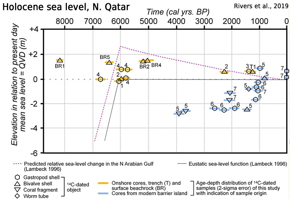
Rivers et al., 2019 Northern Qatar, +1.6 m higher than present
“The Al Ruwais area of northern Qatar has been the site of shallow water carbonate sedimentation since the mid-Holocene. Two distinct depositional packages have been identified. Between ca 7000 and 1400 years ago, when sea-level was up to 1.6 m higher than today, a barrier/back-barrier system was active in an area immediately landward of the modern shoreline. During the same period, a laterally-continuous coral reef flourished in the open waters approximately 3 km to the north. Towards the end of this period sea-level fell to its current position, and the reefal system died, perhaps due to exposure or the influx of detrital sediment. Between 1400 and 800 years ago a new barrier island was established directly on top of the moribund reef, and the old barrier to the south was exposed to the meteoric realm. Over the past ca 800 years the new barrier has retreated landward as much as 1 km to its current position.”
Fachbereich, 2019 Antarctic Peninsula, +14.5 to 16 m higher than present
“Raised beaches along the coasts of Maxwell Bay, located at 7.5 to 4 m amsl (locally termed “6-m-beaches”), interfinger with terminal moraines of the last glacial-readvance (LGR), which occurred between 0.45 and 0.25 ka cal BP (John and Sugden, 1971; Sugden and John, 1973; Clapperton and Sugden, 1988; Yoon et al., 2004; Yoo et al., 2009; Simms et al., 2012). It is therefore likely that these beaches developed during the LGR (John and Sugden, 1971; Sugden and John, 1973; Hall 2010). Recent uplift of KGI was 0.4 mm a-1 during the last decade (Rülke et al., 2015). Average uplift during the entire Holocene, however, is 2.8 to 3 mm a-1 (Bentley et al., 2005; Fretwell et al., 2010). Fall of relative sea level on KGI accelerated during the last 500 years (Bentley et al., 2005, Hall, 2010; Watcham et al., 2011). This was most likely the result of a short-term acceleration in glacio-isostatic rebound after the LGR, with a modeled peak uplift rate of 12.5 mm a-1 between 1700 and 1840 CE (Simms et al., 2012). … Bentley et al. (2005) show that an initial post-glacial sea-level fall was interrupted by a mid-Holocene highstand at about 14.5 to 16 m amsl from 5.8 to 3.0 ka cal BP. In contrast, data presented by Hall (2010) show a continuous sealevel fall, which becomes accelerated between 1.5 and 0.5 ka cal BP.”
Nirgi et al., 2019 Baltic Sea, +10 m higher than present (rate: +3.5 meters per century)
“Considering the elevations of the pre-Ancylus Lake palaeochannel sediments in the Pärnu site and the highest coastal landforms in the area, the water level rose at least 17.5 m at an average rate of 35 mm per year, which is 5–6 m more than proposed by earlier studies in this area (Rosentau et al., 2011; Veski et al., 2005). Similar fast transgression (40 mm/yr), about 21–22 m, has been documented inthe Blekinge area between 10.8 and 10.3 cal. ka BP (Hansson et al., 2018a). … At about 8.2–7.8 cal. Ka BP, the rising Litorina Sea flooded the palaeochannel in the Pärnu site and floodplain in Reiu at an elevation of 1–2 m b.s.l., around 7.6–7.8 cal. ka BP Rannametsa site at an elevation of 4 m a.s.l. and around 7.6–7.4 cal. ka BP Sindi BOM layer at an elevation of 7 m a.s.l. (Figure 7). The Litorina Sea reached its maximum transgressional RSL ca. 10 m a.s.l. [meters above present sea level] just after 7.6 cal. ka BP, most probably around 7.3 cal. ka BP (Veski et al., 2005), as also determined in Narva-Luga region at the south-eastern coast of Gulf of Finland (Rosentau et al., 2013). Thus, during the transgression, the sea level rose by about 14 m at an average rate of 12 mm per year.”

Rasmussen et al., 2019 Denmark, +3 m higher than present


“HH Lamb in his book, Climate, History and the Modern World, offers many examples of this, eg:
“1) The most rapid phases [of sea level rise] were between 8000 and 5000 BC, and that the rise of general water level was effectively over by about 2000 BC, when it may have stood a metre or two higher than today.”
https://notalotofpeopleknowthat.wordpress.com/2016/05/13/sea-levels-in-the-holocene/
“https://notalotofpeopleknowthat.wordpress.com/2016/05/13/sea-levels-in-the-holocene/
Very impressive, shame about all the pay firewalls.
Kevin, I’m sure these revelations will be reprinted by the MSM on their front pages tonight. Better still the BBC will have it on their Home page shortly to correct their recent climate disaster headline from Sir David.
If the ocean levels were higher, then there was more water in the ocean, and so there was less water vapor in the air. Since water vapor is a coolant, that means the air temperature was much higher.
… Unless there’s holes on the botton where the ocean can go.
Did I get that right?
No!
But its OK.
I sincerely doubt, that the amount of water vapour will make a dent in the sea level.
Also doubt that water vapour can and will disappear entirely.
But of course there is holes on the bottom of the oceans, with inflow and outflows.
Of course, some several thousand years ago the earth was completely submerged in a flood.
There is much evidence for this, but as it is contrary to the “old age” of the earth paradigm in vogue at present, the evidence is either ignored, ridiculed, or dismissed.
It took a Russian Black Sea expedition to solve that “biblical” controversy.
There is now no doubt that the Bosporus as we know it broke through to the the freshwater lake , Black Sea, with salt water and a 200 meter flood. That just happened to be the pre-neolithic settlement – artefacts have been surfaced. Fishermen today know not to net too deep – it is poisonous there.
Shortly after, the oldest settlement we know of, Goebekli Tepe,
https://en.wikipedia.org/wiki/G%C3%B6bekli_Tepe
flourished.
The power of the cascade can be estimated from the channel floor erosion.
Whether that was because of the slow Mediterranean refill after the ice age, or a Thera-like volcanic tsunami is debated.
Although no expert, I get the impression that controversy about past temperatures and sea levels has arisen only since the global warming scare has been fostered and specifically since the Mann et al. ‘hockey stick’ graph.
For instance I have a book published in 1976 on the history of the Irish landscape where the author discusses past isostatic and eustatic related sea level movements viz. that the eustatic rise overtook the isostatic land movement resulting in a level ‘~4m above the present level 5000 years ago’ (The Irish Landscape, Mitchell 1976).
It is important in science that ‘conventional wisdom’ be examined and challenged if necessary but the global warming scare of the past 20 years has seen deliberate historical negationism (‘a distortion of the historical record’ – Wiki) Stalin-style .
Controversy?
Try this:
https://en.wikipedia.org/wiki/Fomorians
This myth promotes a people from “under the sea”, raiders, rather like the much later Vikings.
Clearly Fomor comes from Gaelic Faoi Mhara, literally meaning under the sea.
In other words, these raiders came from a place now under water, an earlier coastline.
Controversy starts to froth when one looks at the continental shelf maps, notices a nice underwater river flowing to the western coast as it appeared just before the end of the Ice Age.
In other words how could a saga survive 9 thousand years!
When Schliemann found Troy using only Homer’s Iliad as reference he was denounced, but correct. Homer lived 800 years after Troy, and as we know now described exactly the exact size of the city.
Now bring in Plato’s Timaus – he describes events and places from 9000BC.
Academia is by this point apoplectic with rage.
It did not start with the little Mann and his funny stick.
[…] https://notrickszone.com/2020/01/16/19-papers-published-in-2019-affirm-sea-levels-were-meters-higher… […]
Homer wrote an epic. The epic was passed down over time in written form. It was a major part of Classical education in the West from the time of the Hellenistic Empires until the 19th century. All gentlemen were required to learn it at school. It is still around in translation and in paperback . Troy was not forgotten Just remember that it was in Anatolia and therefore inside the Ottoman Empire where Islamic custom prevailed for hundreds of years and even before that people were not interested in old ruins.. BTW Wikipedia is not a good reference . Read books.
Troy was finally leveled by the Ionians around 1100 BC, a Hittite city-state whose capital was Hattusa, in today’s Anatolia, the wheeled chariot inventors. Apparently the Trojan Horse, wheeled, was a version of a Hittite god (wall relief not easy to find) – Ionians had good intelligence services.
Islam arrived around 640 AD, much later in Anatolia…
[…] K. Richard, January 16, 2020 in […]
In OZ a Phd Palaeontologist said that if we did not do “something” about global warming Bondi Beach would disappear due to sea level rise. That was about 6-7 years ago.
The Beach is still there in all its glory 900 metres wide and 60 metres deep!
PS We had a bigger bushfire event in terms of area in 1974-5
In Norway 8.000 – 5.300 BP most of the glaciers where all gone. Since they returned and have had a cyclic long term increase. The last max was around 1750 AD. The Holocene maximum had higher sea levels because the was less glaciers globally? And if sea level was higher 1.000 BP it would mean that it was warmer than present?
I liked reading all of this item, its really good. I would have a few suggestions though, but dont want to cause a debate :p Anyway, keep up the nice work, and until next time!
[…] https://notrickszone.com/2020/01/16/19-papers-published-in-2019-affirm-sea-levels-were-meters-higher… […]
Climate Warming emergency in an ICE HOUSE world ?
When the Earth is in one of the coldest periods of the last half billion years, the anguish over mild climate warming does not make sense.
Quoting from the article :
“We are currently living in the most recent ice age; we are also in icehouse conditions and have permanent ice on both poles. In the past 550 million years we have been in icehouse conditions about nine percent of the time and the current icehouse is one of the most severe in that period.”
https://wattsupwiththat.com/2020/01/03/earths-ice-ages/