Many climate policies are based on scenarios generated by models. Depending on what these models churn out, actions and costly regulations get enacted to mitigate the worst consequences. So we hope that the modelers get it right. Unfortunately they are still shooting in the dark. Even short term models are failing miserably.
TWC forecast a basket case
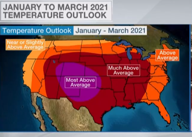
It turns out most models are junk grade when it comes to forecast quality. For example, The Weather Channel here not long ago issued it’s winter outlook up through March:
The area of the US now being hit by one of the most vicious cold waves in the last 100 years was indeed forecast to be “way above normal” or “much above normal”. So far the exact opposite has happened. They never saw it coming.
We have to wonder what it takes to be issued a license to practice weather forecasting nowadays, and we have to feel sorry for those businesses and industries that relied on these botched forecasts.
Yet, these are the type of outlooks that policymakers insist we need to heed and so take immediate (costly) action.
Potsdam Institute’s El Nino debacle
Another example of short to midterm forecasting involves the El Nino events, which have a global impact. Having the ability to predict these events accurately would be a very valuable tool.
And not long ago the Potsdam Institute for Climate Impact Research (PIK) in Germany claimed to have developed a model that could predict the events with 80% probability. A PIK November 2019 press release in fact boasted that its team of renowned researchers had developed a new, far better model – which in November 2019 said was capable of forecasting a late 2020 El Niño event a year in advance.
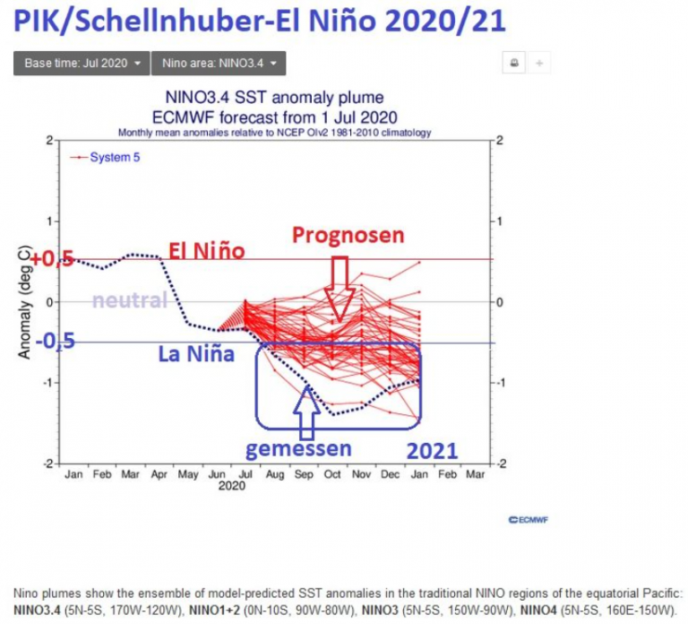
Today in February, 2021, the results are in and they are ugly: The equatorial Pacific 3.4 region is near La Nina conditions, thus in complete contradiction to the warm forecasts of the Potsdam Institute. The “pioneering” PIK model, which in part was developed by Prof. Hans-Joachim Schellnhuber, is a complete failure and totally wrong:
The ECMWF graph above shows ENSO forecasts for the period July 2020 to January 2021 (many thin red lines) compared to measured SSTA in Nino area 3.4 (blue dotted line).
The ECMWF forecasts were on average about one degree Celsius too warm. There have been La Niña conditions since August 2020 with measured values of -0.5°C deviations and colder.
“Model rubbish”
“The ‘pioneering’ PIK model produced model rubbish and disgraced German ‘climate science’ worldwide. Moreover, it currently looks as if the cold La Niña wants to cool us down further until 2022,” reported Schneefan here.

The WC’s February-only map is more astoundingly wrong,
and extremely ugly. Nasty over-saturated colors and a
poor projection just add to the wrongness.
Regardless, I quit checking the Weather Channel
about two years (or 3) ago.
Models are only as good as the data available. The SSW event that led to the polar vortex collapse was hardly a predictable event. Weather models are getting better but still often fail due to these types of events.
I’m not trying to absolve climate models of the damage they have done and are doing to society. They are just plain wrong. They are missing a big part of the overall processes involved. Here’s my description of that problem.
Earth’s greenhouse has windows that open.
A greenhouse prevents solar energy entering through its glass windows from escaping. This keeps the interior of the greenhouse warm. While not exactly like a greenhouse, certain gases in our atmosphere do absorb energy (IR radiation) from the planet’s surface and redirect it back towards the surface. This has led to a description of our atmosphere acting like a greenhouse. it has been assumed that this redirected radiation will warm the Earth. CO2 emitted from human activities is one of those gases.
What if the greenhouse has windows? What if the windows get opened? Will the redirected energy find a way out of the greenhouse??
The answer to all 3 questions is YES. Just like we often open our windows in the evening on a warm day to cool our homes, the Earth’s climate system has the equivalent of windows, these windows open at night and almost all of the energy that has been assumed to be trapped by greenhouse gases is dissipated through these windows every night.
This feature of the climate system is due to the interaction of two seemingly unrelated items.
1) The large difference in heat capacity between the Earth’s surface and its atmosphere.
2) The way moisture controls Earth’s surface cooling.
The high heat capacity of the surface prevents redirected energy from significantly increasing its temperature. The surface has a heat capacity almost 1000 times greater than the atmosphere. As a result, the energy that could raise the temperature of the atmosphere by 1 C will only raise the surface temperature by about 0.001 C even though the energy levels are equivalent. A good analogy would be a container that holds 1 gallon vs. another one that contains 1000 gallons. If you add a quart of water to both containers the first one is 25% full while you’d barely get the bottom wet in the 2nd one.
This small amount of temperature change prevents the air above the surface from warming and the humidity from increasing since those processes are based on temperature and not energy levels.
At night the sun’s energy is eliminated and the atmosphere quickly starts to cool. As it cools the difference in temperature between it and the surface increases. The redirected energy now stored in the surface, along with the heat built up from daytime heating, start to radiate away (into the atmosphere and then into space).
The moisture level of the atmosphere (the dew point) controls how much cooling takes place. When the dew point and the surface temperature are nearly the same, they both radiate energy at the same level. That keeps their temperatures the about same.
Since the atmosphere did not see any increase in temperature during the day from the redirected energy, the dew point is never changed. While it takes longer for the surface to lose its energy due to having significantly more energy than the atmosphere, all the excess energy still gets radiated away. The surface eventually reaches equilibrium with the atmosphere at the about same temperature that would have existed without any redirected energy.
That is the way the redirected energy is removed. The high heat capacity of the surface prevents the redirected energy from significantly increasing its temperature thus keeping the moisture content of the atmosphere fairly constant. It is this moisture content that determines the equilibrium temperature and that temperature ends up almost the same as it would have been if there was no redirected energy. That means the redirected energy is lost … right out the greenhouse window.
Not predictable? Consult Joe Bastardi of weatherbell.com. He predicted it in December. If he could predict it so could the weather channel. Joe knew exactly what the SSW would do since he is a weather historian in addition to being a forecaster. So the clients of Joe’s company had advance warning.
I really don’t know where The Weather Channel has been getting those “month-range” forecasts (their forecast for March is more of the same).
As Joe Bastardi has noted for some time, the CFSv2 has been a total mess for forecasts – it seems to never see anything *other* than warm air. So one wonders if that was the source…
February (weather channel) was forecast to be very warm (vs. long-term averages) in both the northeast and in Texas; of course, February isn’t over yet – and as Dave Burge (aka “Iowahawk”) has noted, if it’s 122F every day for the rest of the month in Austin, they can still make it.
Everyone (myself included) wonders what’s going on with the ECMWF. Over the past decade, the ECMWF established itself as the “go-to” model – as it was head-and-shoulders above anything else. Last winter it was goofy (spent the whole winter perpetually predicting massive snowstorms in the northeast in the 6 – 10 day forecast… that would disappear when the time line got under 5 days), but this winter it’s been plain awful. If it ain’t broke, don’t fix it?
[…] Reposted from NoTricksZone […]
[…] Reposted from NoTricksZone […]
The North Pole is tilted away from the sun, it’s winter, easiest season to make weather predictions, it is going to be cold most of the time anywhere north of the 40th parallel.
Winter snow cover over the North American landmass extends down to Texas at times and a cold air mass can move that far south, much to the chagrin of Texans these days, it is devastating.
30 days to the vernal equinox, winter will be over.
Those meteorologists have to read chicken entrails before they make a forecast. Punxsutawney Phil is better at forecasting the weather.
Onion skins will tell you if winter will be mild or severe, a more reliable predictor, if you want to believe the onion skin theory of weather predicting.
The cold wave has lessened, still is plenty cold though. The lowest temp in the last ten days was -36 degrees Fahrenheit, didn’t make it to -39, but it has been cold.
A state park on the US/Canadian border recorded an overnight low of -59.6° a week ago or so. More or less ties the record low of -60°F set back in the 1930’s.
C=2πr, r=93,000,000, the planet is circling the sun at a speed of 18.5 miles per second.
Kind of tough to predict the weather when you are moving that fast, the weather can change more than you think with the earth bookin’ it through what is going to be cold outer space.
[…] Link: https://notrickszone.com/2021/02/19/junk-grade-models-even-short-term-climate-and-weather-modelers-g… […]
As someone who regularly watches the weather models for both Europe and the world (CFS, GFS, JMA, JAMTEC, CANsip, UK Met Office, DWD, ECMWF, etc.) it really amuses me that the medium and short term models can vary widely with each daily forecast iteration.
Also of note is the wide divergence of outcomes that each member of the model’s group of ensembles can evoke for any day’s forecast.
High and low pressures mostly move from the west to the east, that is baked into the models, also many models appear have far too much of a warm bias in them.
As often happens if an air-mass retrogresses (moves east to west), or a polar air-mass slips slightly more southerly, or some Sahara winds venture northwards, or the dying remains of a tropical storm ventures towards Europe, then these weather models (and their forecasts) vary widely, with many of the models disagreeing with each other about how the weather will evolve.
This is the ‘state of the art’ that very expensive computerized weather forecasting has brought us, not very much more accuracy or reliability than when experienced humans interpreted weather maps and local features to give weather forecasts, as happened from 1940s to mid-1970s.
Showing a weather forecast for more than 1 week into the future and you’re seeing a fantasy forecast that is probably less than 50% accurate (probably much, much worse).
Even weather modelers recognize that forecasts beyond 10 days is not reliable (I contend that 5 days is the limit).
From https://rmets.onlinelibrary.wiley.com/doi/full/10.1002/met.1654
Basically this sophistry just says forecast may be reasonable up to 10 days hence, as these models bash through the numbers but we do not understand all the underlying process governing the weather and it’s variability.
P.S.
The May and September/October predictability difficulty —
There are times in the year when the models are particularly poor for European forecasts, a month or so around May and a month around September/October — watch out for it, it always amuses me how wild and contradictory the models get at these times.
[…] Junk Grade Models: Even Short-Term Climate And Weather Modelers Get It All Wrong […]