By Kirye
and Pierre
The February 2021 data for Iceland and Greenland are available from the Japan Meteorological Agency (JMA), which means the latest meteorological DJF winter mean temperature can be computed.
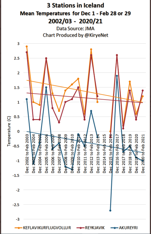
Icelandic winters have cooled since 2001
We plotted the JMA data for three stations (the ones with sufficient data) in Iceland. Result: no warming over the past 18 winters!
Data: JMA.
As you’ll notice, some winter data for Iceland are missing, but there’s enough to show us that winters there have been cooling, and not warming.
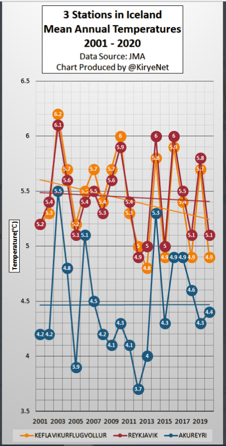
Earlier this year we plotted the annual data for these three Icelandic stations, and found 2 have cooled and the third was stable.
Data source: JMA.
Obviously there has not been any warming at this North Atlantic island since the start of the century. The alarmists are screaming about nothing.
Greenland stations have cooled off
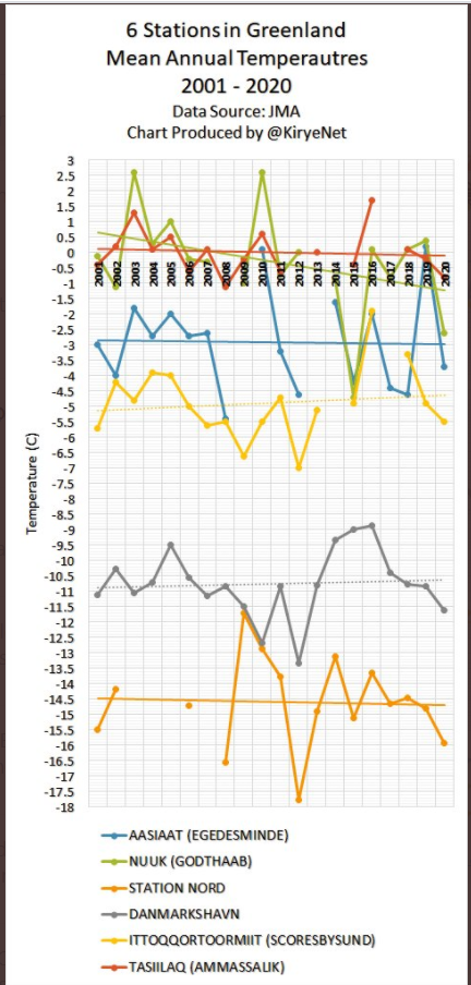
Next we go to Greenland, What follows are plots of JMA ANNUAL mean data for 6 stations on Greenland. A couple of the stations have data gaps, but they still can give us a pretty good idea as to what’s going on.
Data source: JMA.
In Greenland as well we find no real warming going on. It’s all been pretty stable since 2001.
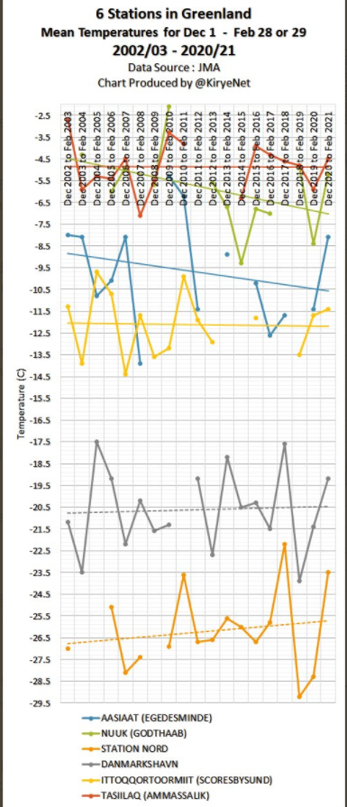
And what about winters in Greenland? The six stations are plotted as follows:
Data source: JMA.
Once again the JMA data for Greenland is somewhat fragmented, but they certainly do a better job than Michael Mann’s tree rings. Altogether, there’s been nothing unusual happening up in Greenland during the winter this century.
2021 Arctic melt refuses to start
Finally, this winter’s Arctic sea ice was still continuing its climb as of March 21st and reached it
Hat-tip: Schneefan.





One of the best areas to monitor for overall atmospheric behaviour is that band between the Atlantic oceanic zone and the European continental zone. This very sensitive area displays well the overall behaviour of atmospheric trends. If warming dominates, the oceanic area will overwhelm the cold continental pattern – and vice versa.
Monitoring the snow levels on the Scottish mountain ranges, month to month, on a year to year basis, gives a very sensitive measure of what is actually happening, a bit like monitoring how high the tide comes up the beach, far better than taking temperature measurements which can vary wildly, a bit like measuring water depth which can – obviously – be varied by wave heights.
At present, snow levels are remaining stubbornly persistent, contrary to media reports, and will be reinforced by forecast snow over the coming weekend. Visual info here :
https://howtheatmosphereworks.wordpress.com/observations-2021/
and earlier years gives a good impression of reality.
Here is the trend for the UAH tlt satellite temperatures (lower troposphere) for the period 2000 – 2020.
North pole -0.063 degC/month
South pole -0.030 degC/month
https://www.nsstc.uah.edu/data/msu/v6.0/tlt/uahncdc_lt_6.0.txt
It’s to be expected that cooling rates high in the atmosphere would be higher than at the surface, but cooling is cooling.
We can take any data and do a linear regression to fit a line to it and get a slope number. But in my professional opinion, such a trend/slope is so small that it is below the noise resolution limit – and any trend is just a noise artifact from what is a stable system with statistical noise around that stable mean.
The more we look at real data, the more-clear it becomes that nothing is happening.
Those temperatures are really mean.
Not cooling fast enough for some, apparently…
https://joannenova.com.au/2021/03/bill-gates-launches-giant-chalk-advertising-campaign-to-block-sun/
[…] Reposted from the NoTricksZone […]
[…] Reposted from the NoTricksZone […]
[…] Kirye & Pierre, March 24, 2021 in […]
[…] Sedan sekelskiften kan man se en tydlig trend mot kallare vintrar enligt JMA, Japan Meteorological Agency, vilket rapporteras av NoTricksZone. […]
[…] Link: https://notrickszone.com/2021/03/24/greenland-and-iceland-mean-winter-temperatures-continue-cooling-… […]