To European readers, don’t let the warm balmy weather we are now getting fool you. This is just evil Mother Nature luring us into a trap. She is about to slam us with a cold blast.
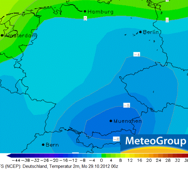
Frosty temperature forecast for Germany for 29 Oct 2012. Source: http://www.ncep.noaa.gov/.
The 15-day weather simulations are beginning to converge and are indicating that a huge mass of polar air is about to sweep across Europe by the end of next week and early November. See the European Center for Medium Range Weather Forecasting (ECMWF) forecast model here at German meteorological site wetter.24
Wetter.24 writes:
The various forecast models have been in increasing agreement over the last days on that a blast of polar air sweeping over Europe will develop over the course of next week. Foremost there is still uncertainty over when it will reach us in Germany.”
According to the ECMWF the cold likely will begin to grip northern Germany and Poland on Thursday. Scandinavia will be hit especially hard, with temperatures plummeting to under -10°C in some regions. Wetter.24 also writes:
The timing is also not so certain, but the probability is high that on Sunday of the coming week all of Germany will be under the influence of really cold air.
Joe Bastardi also tweets a cold blast will grip Europe saying, “…coldest start to Nov in many a year shaping up.”
I think it’s still a little early to say it’s going to be really cold. We’ll get a much clearer picture from the simulations over the next 48 hours. But keep in mind, Joe usually gets them right.

http://www.bbc.co.uk/weather/features/20009874
That high pressure area is going to bring mild weather to the UK.
Why is it that dust silicates from the desert are safe but dust silicates from a volcano can empty our sky of aircraft???
Not all volcano eruptions. Only the ones that jettison particles right into the 10,000 m height range; these are the explosive ones, and the mixture of glacier ice and lava on Iceland leads to violent explosions.
If desert dust manages to get transported up to that height by wind, it probably gets sorted for particle size and the bigger particles don’t make it up there.
And, as we know now, the total EU clampdown on air transport was a childish overreaction.
This BBC report is next week: the cold air comes a week after that.
And as for volcano ash, it’s a glass so melts at a low temperature.
Silicates: Visualize a glass Christmas tree ornament pulverized to micro-sized particles. Or have a look at the real thing:
http://en.wikipedia.org/wiki/File:Ashsem_small.jpg
Glass melts. Glass is an insulator. That combination causes engines to fail.
Desert dust particles are usually not so high in SiO2.
Also, snow in Washington State this weekend and below freezing every night in the foreseeable future.