Early this week a German meteorologist tweeted that Germany had set a new record high for the date in the southern state of Baden Wurttemberg at a station called Rheinstetten. I was even told that the station was fairly new (and thus reliable?).
I’ve noticed that on hot days the Rheinstetten station always appeared to be at or near the top of the list for high temperatures, and so I decided to see if I could get more details about its actual siting to find out more on why this is so.
It turns out that the Karlsruhe Institute of Technology (KIT) maintains the station and provides a good website with important station information. The simple map provided by the KIT site shows the station location (blue arrow) and that it is situated at the southwest end of a glider airfield.
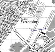
Source: http://imkhp2.physik.uni-karlsruhe.de/~ws_forch/
From the map we see that it is at least in a rural location. An aerial satellite view from Google Maps gives us much more detail:
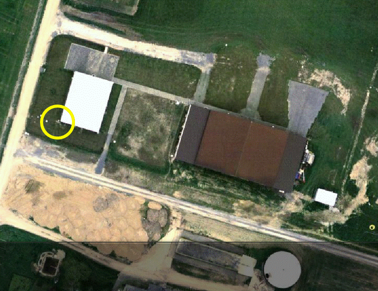
Aerial satellite view of Rheinstetten weather station (yellow circle).
The yellow circle in the photo above shows the suspected location of the station. Its location was deduced by examining the photos of the station available at the KIT site.
The next photo is one of the photos, and it shows that the station is the mast at the far end of the building at the corner. Note how the station is right up close to the metal building. Do metal buildings get hot out in the sun?
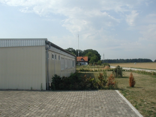
Source: http://imkhp2.physik.uni-karlsruhe.de/~ws_forch/
At the front of the photo we also see a pavestone surface, some 12 meters away from the station mast. Roads are located near the mast as well. They appear to be asphalt surface but had been heavily soiled by excavation works right before the satellite photo was made. They could be gravel as well – hard to tell. Another wintertime photo shows vehicles parked close to the mast.
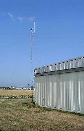
The next photo shows a close-up of the measurement station right near the corner of the metal building.
Source: http://imkhp2.physik.uni-karlsruhe.de/~ws_forch/
The above photo appears to have been taken mid-morning in the summertime. One could imagine that under certain conditions temperature reading could be easily corrupted by the metal building which acts as a heat source, especially in the afternoon. The KIT station website describes the station as follows:
The measurement station is located next to a living container at the gliding grounds of Rheinstetten. The glider grounds are approx. 2 km behind the southwest city limits of Karlsruhe. The surroundings are characterized by a mixture of agricultural land, fields, and some forest to the east. Overall the most optimum conditions prevail for meteorological measurements, especially for wind.”
And temperature? The site also gives information about the processing of recorded data.
The measured data are recorded on site at the gliding grounds using a PC. The computer connects to the recording system of the University of Karlsruhe and transmits the data every 10 minutes. The measured data are processed at the same intervals and displayed at this website.
On the graphics pay attention to the date and time given. In the event of an operational disruption, the data are not updated and so may be old. Longer periods of station inoperation can be read at the site “Statusmeldungen” [status reports]. There you will find information about operational disruptions and the transmitted data.”
Though the station is not horrendously sited, it appears the readings are corrupted and thus could be improved. If this site represents the general quality of Germany’s measurement network today, then we need to take Germany’s weather statistics with a grain of salt. Many German weather stations have been moved. And as we know from other countries, often these stations are moved to less than ideal locations, e.g. airports, next to parking lots and/or buildings.
I’m still trying to determine if this station is part of the German Weather Service (DWD) network. No other station seems to exist in the immediate area.


If any reader happens to be living nearby. It would interesting to know if a building or something has been put on the excavated lot seen in the satellite image.
That looks like a perfect siting for a Weather Station, providing you want to record totally unrealistic temperatures.
Not only does it have a built in Solar Heat Source with the metal building, it also has a built in wind break to disrupt proper airflow with the building being so close to the station.
I would like to see what rating Anthony Watts would give that site.
Hi Pierre,
Interesting article.
I think a world-wide photographic/on-site inspection of all the Global Historical Climatology Network (GHCN) stations (similar to what Anthony Watts et al. did for the U.S. Historical Climatology Network) should be a top priority if we are to continue using these stations to estimate global temperature trends.
Earlier this year, we finished an article analysing the results of Watts et al.’s Surfacestations project. Have you read it? We have submitted it for open peer review here: http://oprj.net/articles/climate-science/11
We’ve also uploaded all our data and code to FigShare, here: http://dx.doi.org/10.6084/m9.figshare.1004025
In Section 5, we offer some recommendations for how the Surfacestations project could be extended to look at non-U.S. stations. One possible approach would be crowdsourcing for individual stations, like you’re doing here for the Rheinstetten station. So, I think this post could be a very important starting point. Have you seen there’s been some attempts to do the same for U.K. stations over at Tallbloke’s blog? http://tallbloke.wordpress.com/category/analysis/surfacestation/
P.S. We also wrote a less-technical summary of our key findings for our blog: http://globalwarmingsolved.com/2013/11/summary-has-poor-station-quality-biased-u-s-temperature-trend-estimates/
A. C. Osborn,
Under the old system it would probably have been Rating 3 or 4 (where 1=best, 5 = worst), depending on whether the metal building is treated as a “heat source”. The pavestone surface would probably count as a “heat source” (as in it absorbs/reradiates thermal energy differently than grass/clay), but is 12m away.
Under the Leroy, 1999 classification, if there is a heat source within 10m of the thermometer it has a Rating of 4, but if it is 10-30m away it has a Rating of 3. This is the original classification system used by Surfacestations, and so was also used by Menne et al., 2010; Fall et al., 2011; Muller et al., 2013; Martinez et al., 2012. It’s also the system we used for our study.
However, since then, Watts et al. have started using a newer system (Leroy, 2010) which they say uses a more nuanced classification. They haven’t published their new ratings yet – apparently because they’re submitting an article for peer review on it. So, I’m not sure what it would be for that…
I have little experience with rating these things, but from what little I know, I was tending to a rating of 2 or 3. A possible rating of 4 as you suggest is pretty harsh, but probably accurate. I’m also interested in knowing what Anthony thinks.
Do we know where the temperature sensor is on that mast? If it is at the top, it is 8 meters above where it should be. If it is at the box at the two meter level, it is at the correct level, but much too close to the building. In either case I make it a 4.
Pierre asked me to come over and look at it.
I had to laugh, because this station is on a “gliding grounds”, and yet the people at this school seem to have no real comprehension of the concept of “thermals” beyond their use in gliding. http://en.wikipedia.org/wiki/Thermal
“I’ve noticed that on hot days the Rheinstetten station always appeared to be at or near the top of the list for high temperatures…”
Simple explanation: The station will catch any heat rising off the top of the building, and it will likely change its high temperature reading for the day based on wind direction.
Have a look here: http://imkhp2.physik.uni-karlsruhe.de/~ws_forch/
Note how the variance in temperature is higher from 10-1400 – that is due to wind and heat transport on the wind as it changes direction and speed. It suggests absolute minute to minute temperature at this station is highly dependent on wind somehting that will assuredly affect the Tmax reading.
The wind direction is from the NE during the peak temperature, which means that heat from the building will be carried SW towards the station (assuming the sat image is oriented North).
By my reconking using the materials provided, both the Leroy 99 and Leroy 2010, on first inspection, this station would be rated a class 5 – the worst of the worst.
It is mind blowing to me that a meteorological/climate school http://www.imk-tro.kit.edu/ would consider this a reasonable station placement, either they put little or no thought into it at all, and this is simply an act of stupidity, or they placed it specifically to get maximum temperature.
Ed Caryl above makes an important point about where the sensor is. Based on my knowledge of stations, it appears the entire sensing instrument package is at the top of the mast, and the box is simply electronics, though anything is possible. Only close up photos will tell us. This photo: http://imkhp2.physik.uni-karlsruhe.de/~ws_forch/PICS/forchheim4.jpg
And the other photos, which show no anemometer wind cups suggests to me that it is an ultrasonic wind sensing station, like this one: http://weathershop.com/nm150.htm
If you can get me a reasonably precise lat-lon for the station, I’ll look at it with some of our more precise tools to determine if my first estimate of class 5 holds up to scrutiny.
And somebody fluent in German should scour the website for specs and/or make an inquiry with them, asking what model station it is, which will help determine where the temperature sensor is in fact placed.
I sincerely hope this station is not part of GHCN nor used to determine any official climate records. It seems to be nonstandard in every way possible.
The word “reconking” above should be “reckoning”
I’ve located the station manufacturer based on a description I found here:
http://www.reinhardt-testsystem.de/deutsch/klima_sensoren.php
It is this sensor, and all in one:
http://www.reinhardt-testsystem.de/deutsch/klima_sensoren/praesentation_klima_sensoren/praesw12.php
That would put the temperature sensor at the base of that sensor package and exposed to thermals from the roof and ground, sensitive to the whims of the wind transporting heat from nearby differences int he landscape and building as we see in their temperature plot I mentioned above.
The school gives this:
Mikroprozessor-Wetterstation
MWS 5MV
REINHARDT System- und Messelectronic GmbH
on this page, http://imkhp2.physik.uni-karlsruhe.de/~ws_forch/
…which helped me figure out what station it was.
Another note, there appears to be a radio antenna mast right next to the sensor package (the tall white stick).
If this is a receive only antenna, no issue. But if it is a two-way radio VHF antenna used to communicate with gliders, it will be transmitting radio waves directly next to the sensor electronics.
Such placement would be a major non-no because you don’t know what effect the radio signal will have on the sensor electronics. These radio signals can induce spurious voltages which may translate to spurious data.
Again, mind blowing placement apparently devoid of any thought from a technical school that should know better.
Indeed MWS 5MV (as per their station description)
Interestingly; their spec. for temperature is ±0.3⁰C. (Good enough for a landing strip.) Sensor is subjected to forced convection.
For those who RTFM (PDF in German), there’s this note:
Lightly translated:
The manufacturer also describes how wind direction is determined from the relative cooling of 3 PTC elements by the wind. i.e. there are tiny 3 heaters; which, while they may not influence the maximum temperatures by much, could influence the minima.
OOPS… got the datasheets muddled. WInd direction sensingis by vane and Hall sensor. It’s the “up-market” weather station without any moving parts that has the PTC heaters to determine wind direction.
Just to confirm Anthony’s concerns as to the proximity of radio transmitters, TFM also notes:
2-cent translation:
“Note how the station is right up close to the metal building. Do metal buildings get hot out in the sun?”
Oh, nothing to worry about really. Those same imaginative computer modelers who cannot seem to get their models to correlate with reality (but ass-ure us that AGW glo-bull warming is “proven” by those same computer models) will have no problem “correcting” the bogus data from this site. Those same computer models can also *prove* that Socialism works and that “white privilege” isn’t just another calculated assault on society in the pursuit of unlimited POWER.
The lat/lon of th station given by the technical school: 48° 58′ 47″ N 8° 19′ 52″ E
is coarse, and off by about 1 kilometer.
The correct lat/lon is:
48.972723°N 8.339132°E
Sorry Pierre, you’ve been umm… polite company hereabouts…
I wouldn’t trust that station without a lot more information.
Recall that I published on most of the major UK stations, is not as easy as it looks. Also a shame the Germans are terrified of being caught out, no Google Street view.
Are you ready for jawdrop?
In this instance the truth is revealed by Bing (Microsoft). Read what I have to say carefully first.
There are sometimes two sets of images. In this case not only two but there is an image join very close.
One set is aerial as Google, often the same images. The other is multi-pass lower level flight and gives oblique view from different directions at better fidelity.
I won’t spoil the surprise.
First view which I hope comes up as intended
You can rotate 90 degrees, with surprises.
http://www.bing.com/maps/?v=2&cp=s4wsmyhpvdm3&lvl=16&sty=b&eo=0&q=48%C2%B0%2058'%2047%22%20N%20%208%C2%B0%2019'%2052%22%20E&form=LMLTCC
Second view
http://www.bing.com/maps/?v=2&cp=48.978585~8.338935&lvl=16&sty=h&eo=0&q=48%C2%B0%2058'%2047%22%20N%20%208%C2%B0%2019'%2052%22%20E&form=LMLTCC
Enjoy. Have a good move around.
Darn it, didn’t link correctly. Flip “aerial”
Sorry, but I don’t follow you. If I blundered, just tell me where. I see that bing shows changes in the surroundings which means the Google photos are old. The station is also not in the Bing aerial view. Obviously something is wrong.
Tim Channon, you have the wrong lat/lon for your Bing views. The station is over 1km away at this lat/lon which is correct.
48.972723°N 8.339132°E
The correct Bing view is: http://binged.it/1oXV4qn
I don’t see anything relevant to the actual station location in your Bing views. Please advise if I have missed something from your somewhat cryptic “jaw drop” post above.
You are right Anthony, I was worried about the location.
The explanation is the second set of images does not extend to the weather station location. Dammit.
How much very recent building and redevelopment is going on, that is what was being shown.
I’ll have a dig, not that much is likely to turn up.
The Bing aerial photos show recent building re-development, yet the KIT photos show the weather station at the corner of the building.
It is a software bug!
Problem now is how to trip your browser / Bing to switch mode near a map join.
(before anyone plays blame Microsoft, I could show some nutty Google problems too)
Instructions which I hope work, bug workaround several ways to do this
1. Use Anthony’s link : http://binged.it/1oXV4qn
2. Get rid of the box with messages, zoom etc. and I expect a blue circle marker on the point of interest.
3. Look at the scale rule bottom left, zoom out until it shows 2 miles.
4. Go to the menu just above the image, menu item which will read Aerial. Select Bird’s Eye
5. Now zoom in, at scale 2500 feet the screen hopefully with “melt” and the rotate scene arrows appear. The patchwork of different images is now showing, some one image some multiple.
And in you go. Max zoom is not valid in this mode. In this case rotate actually gives a view of all 4 building walls.
Good luck.
Station? Reckon Class 4 or worse, has to be a screen at a valid height anyway..
I googled Rheinstetten Wettermessstation and and see that meteomedia.de gives coordinates 48.97°N: 8.32°E. and that leads me to this location southwest of the airfield: 48.968895, 8.318605. https://www.google.de/maps/place/48%C2%B058'00.0%22N+8%C2%B020'00.0%22E/@48.9689159,8.3184802,126m/data=!3m1!1e3!4m2!3m1!1s0x0:0x0?hl=de
Is that the shadow of a weather station out in the field? If it is, then it is not a bad location.
The DWD gives the coordinates: 48.97°N 8.33°E for its Rheinstetten station (you’ll have to convert to mins/secs). Where’s the German precision when you need it!
Turns out it’s just a power line tower…
As far as I can tell it is part of the DWD network as I can’t locate any other measurement station in that area.
Probably got it. A new full station built circa 2007.
Guessing this was an asphalt runway aerodrome (definite) and market gardens / gov, redeveloped as large complex, one right over the runway, end is still visible.
By a tiny road named Heckelweg
From Google Earth images 2009 or 2011
48.972619° 8.330227°
Bing images cut it in half. Use “aerial” view and co-ords as Google.
If this is correct the station moves and changes pose problems. Moved toward water which is not typical of area. Market garden seems close.
What do typical DWD (or whatever) stations look like?
Confirmed
http://www.strassenkatalog.de/osm/dwd_wetterstation_rheinstetten,37690165w.html
Great – thanks for all the tips and help!
Had a look at the weather when it was hot. This looks feasibly to have been fohn conditions, if so that might explain things. Bit odd because I would expect the media to mention this at the time. Well known local condition, was invented in Germany, wind off Alps.
So warm and dry that they named their hair dryers after it. (“Föhn”)
This wasn’t really a fohn condition is this case. In my last post I mention that a low pressure system situated for days over the Atlantic off the coast of western France pumped North African air over the Bay of Biscay, where it picked up moisture, and delivered it over central Europe. In this case the air mass was more humid than what we typically get with the “fohn” phenomenon.
I’m lost. Do the pictures in the post show the weather station or not, and is it a 5 or a 1, or is the station relocated and we don’t know anything?
The pictures show the Rheinstetten station from different angles. We know the station is operating at the glider airfield, but not confirmed if it is being used by the German Weather Service. It appears that it is.
PeterF, is somewhat complicated: –
Pierre tried to find the weather station and given no accurate location is available he reasonably picked up a nearby minor weather station with the same place name and a web site with pictures and a latitude / longitude (is wrong, see below)
That web site is about a station actually at a tiny flying club, not the DWD station. The article is based on that.
I saw the article, decided to try and get a better look.
Logically I started with the latitude / longitude, which is for an older station at an old airfield, flying club has moved. On searching the aerial images I picked up the wrong building.
At this point fate steps in, I posted Bing links but did know an unknown software bug at Bing was going to strike. That is a side issue.
Anthony Watts then commented in response to me giving a Bing link to the the flying club building shown in the article photos.
Then it turns out that is not a proper weather station, it is not the DWD station.
I then found the DWD station. See comment at 12. Juni 2014 at 22:07
Confirmation with photo of the DWD station is revealed in comment at 12. Juni 2014 at 22:19
Simple? This is life playing tricks on people. 🙂