Update: Latest model run now shows less cold after New Year’s day…so fast can the weather in the future change!
================================
Much of Europe has been enjoying a mild fall, and early winter thus far as a long series of Atlantic lows laden with warm, Atlantic air masses have been sweeping regularly across the continent.
For winter sports enthusiasts this has not been good news. But for people on a tight budget, the reduced heating bills and low heating oil prices are very welcome news.
Cold returning after Christmas
But the warm weather pattern is about to be interrupted, and now is certainly no time to be putting the winter coats and snow shovels away.
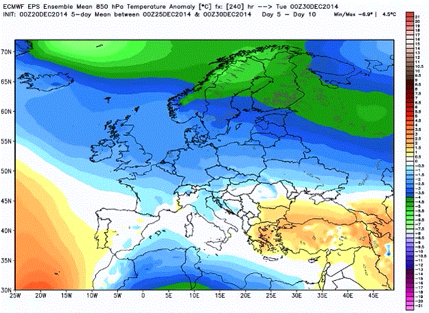
Over the last few days, the weather model runs have been converging on a cold weather pattern taking over Europe right after Christmas. Weatherbell Meteorologist Joe Bastardi also briefly mentioned this in his latest Saturday Summary (5:27), showing the European model for the 5 days after Christmas:
Image cropped from Weatherbell Saturday Summary.
Meanwhile over the last couple of day GFS models have been consistently showing a return to winter on December 26, which for many places in Europe is called the “second day of Christmas”. Some places in Central Europe may even see light snow, even though not long ago a number of meteorologists were telling the public to write off snow for Christmas.
European winters getting colder
So is Europe seeing fewer white Christmases? Wetter.net meteorologist Dominik Jung recently wrote a few weeks ago that there has been no trend in the last 100 years showing white Christmases are becoming less frequent. Overall weather data show that Central European winters have been getting colder over the last 15 years.
Moreover the “Beast from the East” type winters tend to occur when solar activity is low, which means as solar cycle 24 begins to die off, cold and vicious winters may be more common in the second half of the current decade. And should solar cycle 25 be a weak one, as many experts expect, then Europe may be on the doorstep to a couple of decades of generally brutal winters.
Happy shivering New Year
Back to this winter, for the next 15 days or so, a slight thawing is shown to take place before cold really returns in time for New Year’s day. The latest GFS model runs shows widespread frost gripping most of Europe on January 1, 2015 and continuing for a few days.
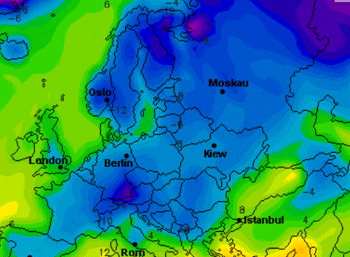
GFS forecast for January 1, 2015. Image cropped from Wetteronline.de.
The good news is that the upcoming cold does not appear to be the stubborn “Beast from the East” type, which is notorious for sometimes lingering all winter long, as was the case in 2009/10. But as variable as European weather can be, nothing can be ruled out.


brrr
Locally, the weekly outlook is for daily maximum temperature to exceed 32⁰C with overnight minimum dipping a little below 20⁰C. (Weather forecasts being what they are — generated by the Bureau of Meteorology using dubious models — I’m also preparing for thunderstorms and hail.)
Relative humidity is usually below 50% around here in the south-west corner of Western Australia.
I’ll be thinking of you over Christmas/New Year as I have a relaxing beer outdoors in the late afternoon; should the hail storms fail to appear.
According to Iceage Now there is plenty of cold going around.
North America
Japan
North India
Russia
Canada
Korea
Turkey
China
Algeria
Kazakhstan
Bulgaria
Austria
So the rest of us in Europe should be very grateful for the position of the Jetsream at the moment.
The U of Maine Climate Reanalyzer for today shows cold in South America, but that’s about it. Very warm in Canada, Siberia, Europe and the US:
http://cci-reanalyzer.org/DailySummary/index_ds.php
Where I live in Oregon, the last 12 months have been +2.7 F compared to the 20th century average.
I wouldn’t know. Was there recently but didn’t stay long. Somebody agreed with somebody else that breathing was natural or some such. Nobody else came to that desolate place. Nobody cared. It made me feel lonely and I left.
“Where I live in Oregon, the last 12 months have been +2.7 F compared to the 20th century average.”
Run for the hills! Oregon is 0.0001 percent of the Earth’s surface, David.
That’s a an awfully small cherry!
Dirk, it’s 0.050%.
Please learn how to calculate.
I think all the cold is being collected in Canada, mostly north of the Great Lakes. By the end of the first week of 2015 expect to hear about it. It will seep south into northern Florida.
Why do some of my comments show up here, and others do not?
It seems like any comment with a link in it vanishes….
Why? Now you have gotten an echo! But not quite, I see : and then ….
Seriously, there is a gremlin in this web hosting setup. Often when one hits submit there is a return to the top, nothing else. Sometimes there is a yellow bar with a message. The comment may or may not appear later. Most often it does appear immediately. Cheer that. If you try to submit the exact thing twice you get a message in German. Uff da. I don’t read German. The great thing about Pierre’s site is that he translates and provides material we would not see otherwise. I sometimes remember to thank him for that. So don’t think the glitches are personal.
Merry Christmas
Yes, this is a very difficult blog to deal with. Comments show up only sometimes. Maybe they do later, maybe not. Some comments are moderated and some are not. It’s a crap shoot.
Plus there is no way to receive notification of new comments (that I’ve found).
P, you need a better platform. Ciao.
So I’ll try this: Canada is well above normal right now:
http://cci-reanalyzer[DOT]org/DailySummary/index_ds.php
So I’ll try this…. Canada is well above normal right now:
cci-reanalyzer[DOT]org/DailySummary/index_ds.php
The warmists know extreme weather events are on the increase. They rely on the fact that the general public are uneducated on the subject of climate change. On a cooling world it is the polar regions where most temperature is lost. This increasing temperature differential between equator and polar regions effects air pressure which effects wind speeds. Result is more gales and bad weather.
All this bad weather is very visible to the public via the media and is excellent propaganda for the warmist cause. The fact that wind turbines blow down if they are not turned off and solar panels see little or no sun is simply ignored. The dumb public don’t notice.
The beasts from the east occur when high pressure settles over Scandinavia and then migrates toward Greenland. In the UK there is a saying along the lines of : winds from the east will last for a week at least