Tanzania’s sea level over the past 4500 years likely succeeded today’s level. Sea level at the Seychelles stable over the past 10 years
By Dr. Sebastian Lüning and Prof. Fritz Vahrenholt
(Translated/edited by P. Gosselin)
Global sea level is rising and rising – and that has been so for the last 15,000 years. However there are indications that the rise was not continuous and that there have been phases where sea level was stable, and perhaps even dropped. That may have happened during the natural cold phases, which occurred about every 1000 years.
Using geological methods it is possible to reconstruct the sea level history. A group of scientists led by Sarah Woodroffe of the University of Durham in North England took a close look at the sea level in Tanzania and the Seychelles far off the east coast of Africa. In a first study that appeared in the May 2015 issue of The Holocene journal, Woodroffe and her colleagues reconstructed the fluctuations at the coast of Tanzania over the past 10,000 years. At first the sea level rose rapidly and reached a level 7900 years ago that is 3.5 meters below today’s level. 900 years later the sea level reached today’s level. After that sea level rise slowed down. It cannot be excluded that sea level afterwards did not exceed today’s current level. In the last 4400 years sea level dropped and then remained constant.
The following is the abstract of the paper:
“Radiocarbon dating of mangrove sediments to constrain Holocene relative sea-level change on Zanzibar in the southwest Indian Ocean
Mangrove sedimentary deposits are sensitive to changes in sea level and can be used to reconstruct mid- to late Holocene sea-level fluctuations in intermediate and far-field locations, distant to the former polar ice sheets. However, they can be difficult to date using 14C because mangrove sediment can contain mixtures of carbon of different ages. The two main potential causes of error are younger mangrove roots penetrating down through the sediment column and bioturbation by burrowing animals which moves carbon up and down the sediment column. Both processes may introduce carbon not representative of the age of deposition of the layer being dated. This study reports new 14C dates on organic concentrates (10–63 µm) from mangrove sediments from Makoba Bay on Zanzibar (Unguja) where previous bulk sediment 14C age–depth profiles contained inversions and were therefore less useful for relative sea-level (RSL) reconstruction. Dates on organic concentrates provide a more coherent sequence of 14C ages compared with those from bulk sediments. These new data provide an improved environmental history and mid- to late Holocene RSL record for this site. Our reconstructions show that RSL rose during the mid-Holocene and reached within −3.5 m of present by c. 7900 cal. yr BP. RSL slowed as it reached present at or shortly after c. 7000 cal. yr BP, with falling and/or stable RSL from c. 4400 cal. yr BP to present. We are not able to determine whether there was a RSL highstand above present on Zanzibar during the mid- to late Holocene. The RSL reconstruction agrees broadly with changes predicted by the ICE-5G geophysical model, which includes 4 m of ice equivalent sea-level rise between 7000 and 4000 cal. yr BP. Our new dating approach has the potential to provide improved chronologies with which to interpret sea level data from this and other mangrove environments.”
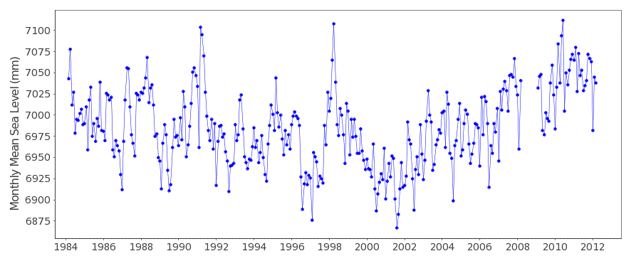
What a surprise: Over the last 4500 years sea level along Tanzania has fallen or remained stable. And what do the coastal tide gauges of the country say? Luckily there’s a gauge at Sansibar which has been delivering data since 1984 (Figure 1). No real long-term trend can be discerned for the past 30 years. Interestingly a cycle can be suspected, with a decline until 2000 and then followed by a rise. Today’s sea level was reached on multiple occasions over the last 30 years.

Figure 1 : Sea level development at the Sanibar coastal tide gauge in Tanzania. Source: PSMSL.
In a comparison study, Sarah Woodroffe’s team also examined the Seychelles, which are located at a distance far from the Tanzanian coast. At this remote location in the middle of the ocean tectonic lifting and sinking effects can be practically excluded. Also here the scientists found a very stable sea level for the past 2000 years. Within the framework of the reconstruction accuracy, it could be determined that during this period the sea level was never 2 meters below today’s level. However a sea level of a few decimeters over today’s level could not be excluded.
The paper appeared also in May 2015 in the Quaternary Science Reviews. The abstract reads as follows:
“New constraints on late Holocene eustatic sea-level changes from Mahé, Seychelles
This study provides new estimates of globally integrated ice sheet melt during the late Holocene (since 4 ka BP) from Seychelles in the western Indian Ocean, a tectonically stable, far field location where the necessary Glacial-Isostatic Adjustment (GIA) correction is small and is relatively insensitive to predictions using different Earth viscosity profiles. We compare sea level data from Seychelles to estimates of eustasy from two GIA models, ICE-5G and EUST3, which represent end-members in the quantity of global melt during the late Holocene. We use data from a range of coastal environments including fringing reef, present day beaches, fossil plateau and mangrove deposits on the largest island of the Seychelles archipelago, Mahé to reconstruct relative sea-level changes. Our data suggest that extensive coastal deposits of carbonate-rich sands that fringe the west coast formed in the last 2 ka and the horizontal nature of their surface topography suggests RSL stability during this period. Mangrove sediments preserved behind these deposits and in river mouths date to c. 2 ka and indicate that RSL was between −2 m and present during this interval. Correcting the reconstructed sea level data using a suite of optimal GIA models based on the two ice models mentioned above and a large number (c. 350) of Earth viscosity models gives a result that is consistent with the sedimentological constraints. When uncertainties in both model results and data are considered, it is possible to rule out eustatic sea levels below c. 2 m and more than a few decimetres above present during the past two millennia. This uncertainty is dominated by error in the reconstructions rather than the model predictions. We note, however, that our estimates of eustasy are more compatible with the EUST3 model compared to the ICE-5G model during the late Holocene (2–1 ka BP). Our evidence from Seychelles shows that the timing of when eustatic sea level first rose close to present is between the predictions of the two end-member GIA models presented here (4 ka BP for ICE-5G and 1 ka BP for EUST3). Using all lines of evidence currently available from Mahé we suggest that the eustatic contribution during the last 2 ka has been less than 2 m. This conclusion is drawn from a tectonically stable, far-field region that is relatively insensitive to earth and ice model uncertainties, and implies that global eustasy has been relatively insensitive to climate fluctuations over the pre-industrial part of the last 2 ka.”
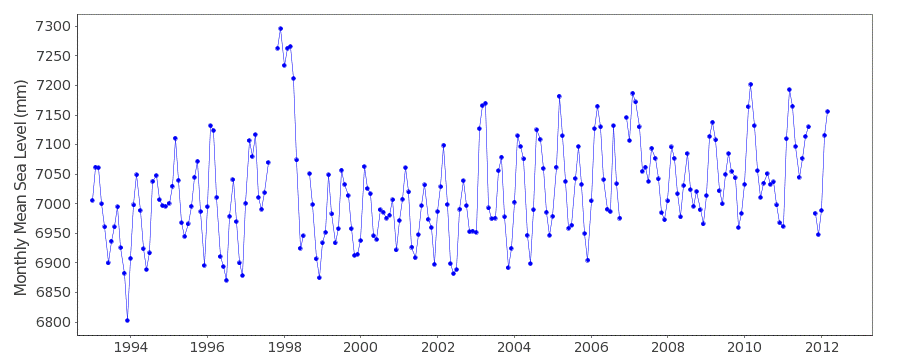
Here as well we examine the coastal tide gauges. The Point La Rue station, which apparently has been inactive since 2012, shows an interesting trend. Sea level has not risen at all since 2002 (Figure 2).

Figure 2 : Sea level development at the coastal tide gauge Pointe La Rue at the Seychelles. Source: PSMSL.
What do the satellite measurements tell us? Also here we see there has been no sea level rise over the past 10 years! (Figure 3).

Figure 3: Sea level development in the region of the Seychelles based on satellite measurements. Source: University of Colorado.


H. H. Lamb, in his Climate History and the Modern World, wrote that sea levels reached their maximum about 2,000 BC, if memory serves me. My copy is not at hand.
To flesh out that statement, here is a quote from Lamb:
“It was after 2000-1500 BC that most of the present glaciers in the Rocky Mountains south of 57 o N were formed and that major re-advance of those in the Alaskan Rockies first took place.
“And at their subsequent advanced positions – probably around 500 BC as well as between 1650 and 1850 AD – the glaciers in the Alps regained an extent, estimated in the Glockner region, at about 5 times their Bronze Age Minimum, when all the smaller ones had disappeared.”
https://notalotofpeopleknowthat.wordpress.com/2014/05/13/hh-lambs-climate-history-the-modern-world-in-review-pert/
2000BC… That is about the time the aptly name “Neoglaciation” started.
This is when the global temperature started to cool more rapidly from the warmer first 6000 odd years of the Holocene.
Right now we are in a decidedly COOL period, only a fraction above the coldest period in the last 10,000 years.
https://vimeo.com/14366077
“their are” in the beginning of the second sentence of the first paragraph should read, “there are”.
Thanks!
Book and documentary.
‘The Deliberate Corruption of Climate Science’.
https://www.youtube.com/watch?v=tPzpPXuASY8
https://www.youtube.com/watch?v=tPzpPXuASY8
https://www.youtube.com/watch?v=sO08Hhjes_0
http://www.drtimball.com