Schneefan at wobleibtdieerderwaermung.de here does a good job summarizing weather and climate trends. His latest focuses on the ENSO, which is a powerful Pacific driver of global weather.
Earlier this year a number of experts projected that another El Niño would appear later this year, and thus keep global temperatures elevated and thus end the pause in global warming we’ve seen since the century began.
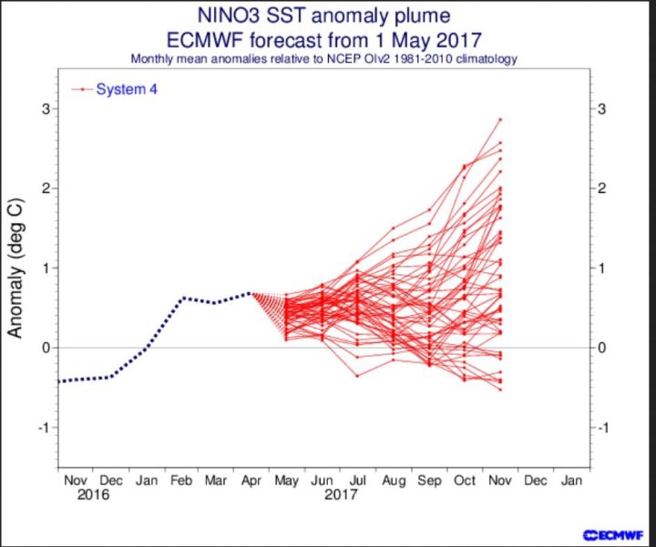
For example the May ECMWF ENSO projection saw powerful El Niño conditions brewing for this coming fall, with an anomaly of up to +3.0° K!
Source: ECMWF ENSO FORECAST.
But already in April other forecasters started revising their projections downwards as nature started to show she had other plans in mind. Today it strongly appears La Niña conditions are going to emerge after all.
The result? The “Al Gore effect”.
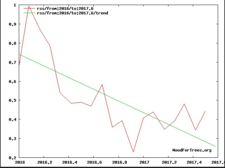
Expect the cooling we’ve seen over the past one and half years to continue even through 2018.
Figure 1: Global lower troposphere temperature (1500 m) anomalies have been cooling since the El Niño peaked in early 2016. Source: www.woodfortrees.org/graph/trend.
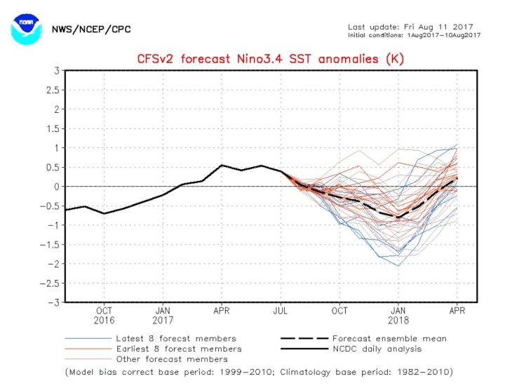
The mid August 2017 CFSv2 prognoses for the equatorial Pacific 3.4 zone surface temperature projections now indicate La Niña conditions by October:
Click to enlarge. Source: www.cpc.ncep.noaa.html.
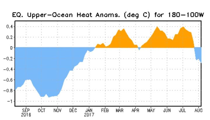
To know what’s behind the latest development, we look at the ocean heat content anomalies of the upper 300 m of the ocean in the equatorial Pacific. The following chart shows a return to the negative range at the end of July 2017.
Source: www.cpc.ncep.noaa.gov/MJO/enso.shtml
The following chart shows what’s going on just below the ocean surface: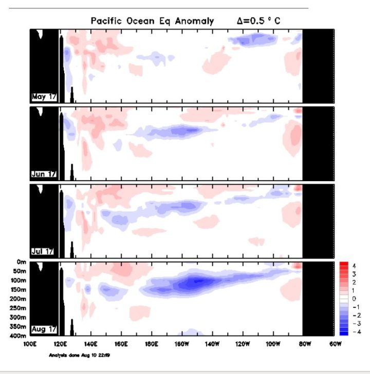
Source: 4-month sequence of Pacific Ocean Equatorial temperature anomaly cross sections
Clear to see is the cold emerging La Niña mass under ocean surface in August 2017. That spells generally cooler global conditions for the months ahead.
Global warming “reality check” of 2017
With Arctic ice mass growing and the Antarctic showing cold surface anomalies, Schneefan calls the recent development: “The Global Warming“ Reality Check”!
Once again we see that experts are a long way from understanding what the system is doing, and thus make forecasts dealing with the climate totally fraught with uncertainty. We can only look forward to late fall.

This US truck driver is not looking forward to another La Nina winter.
If between May and August you reverse your prediction, your soothsaying is not worth a nickel. The group should be sent back to school with an F.
Don’t worry guy’s the “manufactured consent” guys will be along with another hoax shortly :-p
I often watch (via http://www.gavsweathervids.com/) the CFSv2 and ECMWF projections (and JMA, China, Canada, Brazil weather, etc.) of NAO, AMO, and Nino over the years, and all I can say is they are getting better but they do appear to be little better than codified guesswork. For instance earlier in the month gavsweathervids has a shot of the CFSv2 El Nino projection from the beginning of July that shows a maximum projected dip of -0.5 to happen before January. Yours CFSv2 El Nino projection is from later in July and show -1 deeper dip happening during January.
Yep, all these modeled weather projection are certainly not error-free, and that ECMWF El Nino forecast looks like it is the output of a random number generator. But then again how could these models get it right when they’re run and maintain by the congregation of AGW church?
Those models have a 3-4C range.
In other words 95% of them have got it wrong and the other 5% were lucky.
They can only be considered to have predictive value if they
Get it right for 5 years in a row.
They are unfit for purpose.
In AR3 the IPCC stated in working group 1 section that the climate is a coupled non-linear chaotic system that is impossible to predict. Hmm, guess the laws of physics have changed since then. Who knew.
The same happened in 2016. For about 4 or 5 months ENSO was negative, and La Nina was forecast and was an on/off affair, before the authorities eventually called it off.
Then in 2017, ENSO has been positive and the authorities have been predicting an El Nino, but in the last few weeks ENSO has returned to nearly neutral.
Certainly it does not appear that we will see a double El Nino (ie., a further El Nino this year to follow on from the back of the strong 2015/16 El Nino).
Whether we will see a La Nina, we will have to wait and see.
Whilst we may not be able to predict whether we have a La Nina, we are able to predict what will happen if we do see a La Nina.
If we do see a La Nina, then if it is a strong one, or one that persists for a long time, it is probable that the PAUSE will make a reappearance, but this time it will be around 20 years in duration. That would be very awkward for the writing of AR6.
The latest (Issuance in mid-Aug) Experimental Constructed Analog forecasts by NOAA show Nino conditions until next NH spring : http://www.cpc.ncep.noaa.gov/products/people/wd52pp/sst/201707/cat2m_anom.4.png , and then turing into Nino ASO2018 : http://www.cpc.ncep.noaa.gov/products/people/wd52pp/sst/201707/cat2m_anom.12.png ,
http://www.cpc.ncep.noaa.gov/products/people/wd52pp/sst/201707/real.nino34.ca_fcst.png
Source: http://www.cpc.ncep.noaa.gov/products/people/wd52pp/
Other NOAA experts: The latest (Issuance in mid-Aug) for the Experimental Constructed Analog forecasts by NOAA show Niño conditions until next NH spring :
http://www.cpc.ncep.noaa.gov/products/people/wd52pp/sst/201707/cat2m_anom.4.png ,
Turning into a Niña later in 2018 : http://www.cpc.ncep.noaa.gov/products/people/wd52pp/sst/201707/cat2m_anom.12.png
Plume : http://www.cpc.ncep.noaa.gov/products/people/wd52pp/sst/201707/real.nino34.ca_fcst.png
Source: http://www.cpc.ncep.noaa.gov/products/people/wd52pp/
And as the temperatures start to drop back toward those of the pre last century Grand solar maximum,
I bid thee all a farewell.
To the resident AGW trolls.. (you know who you are)
…. you can buy rags at Walmart (or similar) to wash the egg off your faces over the next several years.