Making forecasts concerning weather and climate is not an easy task. There is really much we do not understand, though some like to make you think everything is all understood and settled.
This is why I get a kick out of people who claim they are able to predict decades into the future, yet have very little data about the oceans and their cycles, which play a huge role in climate, and can’t even predict the El Niño Southern Oscillation (ENSO.
Nothing demonstrates the woeful lack of certainty regarding forecasting better than the ENSO forecasts made this year.
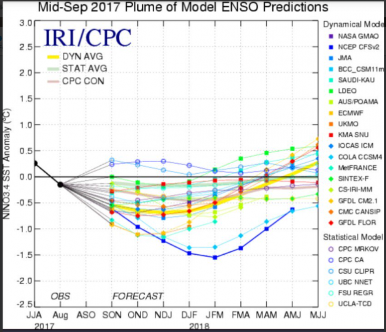
Joe Bastardi here at Twitter showed the following 2 charts from the International Research Institute (IRI), where the first one shows the forecast made in April and the second one shows the forecast just made this month:
The forecast made in April 2017 above shows a powerful El Niño in the works, with equatorial Pacific surface temperatures at about 1°C above normal.
The second chart above shows the recent mid-September forecast, which is now completely opposite. It indicates a La Niña in the pipeline, which means early next year’s satellite sea surface temperatures will be cooled down and the overall global temperature trend will have been flat for some 2 decades.
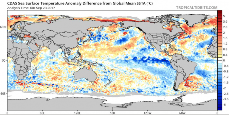
In the following chart from Tropical Tidbits here presents what sea surface temperatures are at the moment:
Note the relatively frigid equatorial Pacific sea surface temperatures. According to the April forecast (first chart above) by the IRI, we were supposed to be in warm El Niño territory by now, some 1°C warmer.
Also note how much the recent hurricanes have cooled parts of the Atlantic and Caribbean. Still, there’s much contrasting warmth south of the Gulf of Mexico and like meteorologist Joe Bastardi says, the conditions and patterns continue to be ripe for more hurricane incubation.
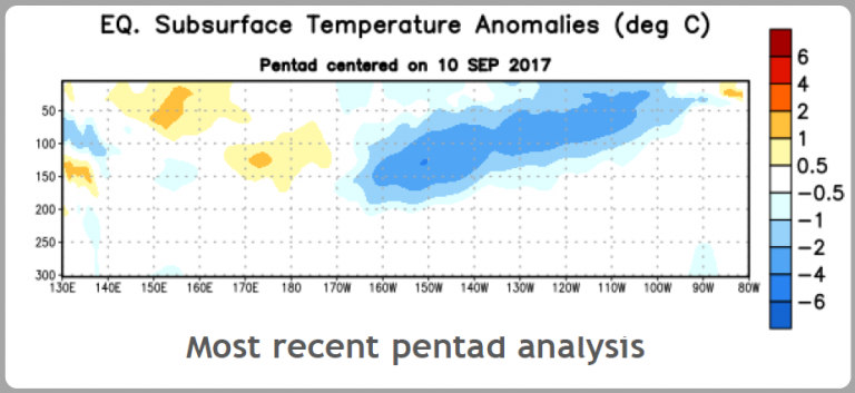
Next we see the subsurface sea temperature anaomalies for the equatorial Pacific down to 300 meters depth:
Chart: NOAA.
Four months ago subsurface temperatures were much warmer, see page 12 here. Today the NOAA says there is an increasing chance (~55%-60%) of La Niña during the Northern Hemisphere fall and winter 2017-18.
So what can we draw from all this? Expect continued global cool down in the months ahead. At the same time, never exclude the possibility of surprises.



UPDATE: Australian flights to Bali are continuing as scheduled amid fears an active volcano on the Indonesian island will erupt for the first time in more than half a century.
A bad Mt Agung tropical eruption, with a quiet sun, and …
http://www.theaustralian.com.au/news/world/thousands-evacuated-as-bali-volcano-sparks-fear/news-story/7a323056f5e512345575a14cf4e1f213
It depends upon the altitude to which any aerosols are ejected.
Personally, I would not wish to see a volcano to muddy the waters. Let us see what a La Nina and/or a quiet sun will do to temperatures.
A deep and prolonged La Nina is likely to result in the pause reappearing, and if that happens it will make the writing of AR6 more difficult, since not only will there have been no temperature rise this century, it will further exacerbate the difference between model projections and actually observed temperatures. It will strengthen the argument that models are running too hot, and that Climate Sensitivity to CO2 should be reduced.
Richard, the warming trend this century is already well below the IPCC per decade predictions,which is .30C per decade.
http://www.woodfortrees.org/graph/rss/from:2001/mean:12/plot/rss/from:2001/trend
.10C per decade right now this century. The renewed pause would only add onto the AGW failure,since it ALREADY failed.
Why is it that people act like they know everything with very little evidence.
Global cool down coming? Yeah, could have said that with the suns rapid decend in activity. Average sunspots drop, the cooler the earth…
By 2021, activity will reach it’s lowest point and then start ramping back up. On a larger scale though, we are heading for a sharp decline in global temps over the next hundred years.