The past winter in central and northern Europe was quite warm. Why is that? The Norwegian Centre for Climate Research CICERO explains it in an article from 6 January 2020:
Unseasonal temperatures for Norway
The unusual warm temperatures this winter and forecasts indicating milder winter conditions for January, February and March in Europe are partly due to an atmospheric circulation pattern called the North Atlantic Oscillation, or NAO. This atmospheric circulation pattern explains well the weather we get in Europe, especially in winter.
As explained in a CICERO-article from November 2019, seasonal forecast models are sometimes able to correctly forecast the phase of the NAO. 6 different seasonal forecast models are run at the beginning of each month by their respective weather centres from around the globe. The October simulations gave us a hint that we might get a positive phase of the North Atlantic Oscillation for November, December and January. The signal was quite strong, and 4 out of the 6 models were clearly in that direction, while 2 suggested normal winter conditions. The November simulations gave similar results, the majority of the models showed a positive NAO for December, January and February. Experts were a bit puzzled, as at the same time the snow cover over Siberia was already quite extensive, and the Arctic was very warm, two things that usually suggest a cold winter for Europe.
And then came the December simulations, the most recent ones, where all six models hinted to a positive NAO for January, February and March, and therefore milder conditions than normal for northern Europe in particular.
Read more at CICERO. An excellent report, which also applies to Central Europe.
For those who don’t know it yet: The NAO (North Atlantic Oscillation) controls the winter temperature in Northern and Central Europe. Positive NAO brings warm winters, negative NAO brings cold winters. Please note!
Now some of you will ask, what is this NAO actually? Well, it is the difference in air pressure between Iceland and the Azores. If the difference is big (pronounced low and pronounced high), then the NAO is positive (NAO+). If low and high are a bit thin, so the difference is smaller, then the NAO is negative. It’s as simple as that.
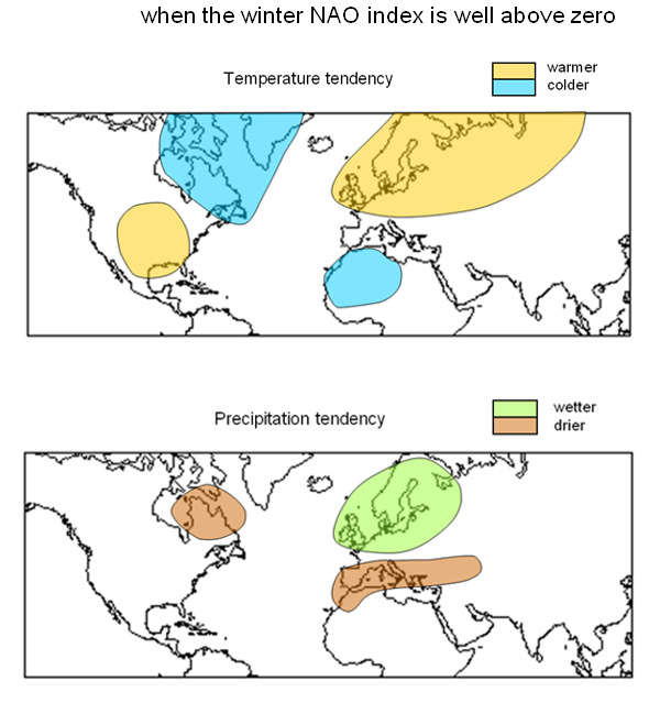
Why is it important? This pressure difference pushes the westerly winds a little bit more to the north or south. In an NAO+, the westerly wind belt lies further north and meets central Europe. This is where the humidity (wet February 2020, does anyone remember?) and the relative warmth of the Atlantic occur.
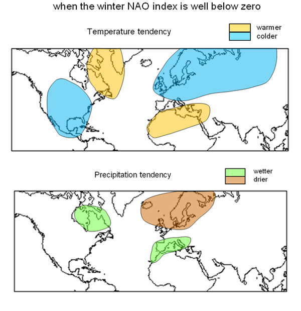
In a negative NAO (NAO-), the westerly winds blow further south and discharge their humidity as rain in Portugal and Spain.
For those who want to know more, the NAO website of the British MetOffice is recommended. We take the liberty of reproducing the two most important graphs of the website here. And this is how it looks with a positive NAO:

And this is how a negative looks:

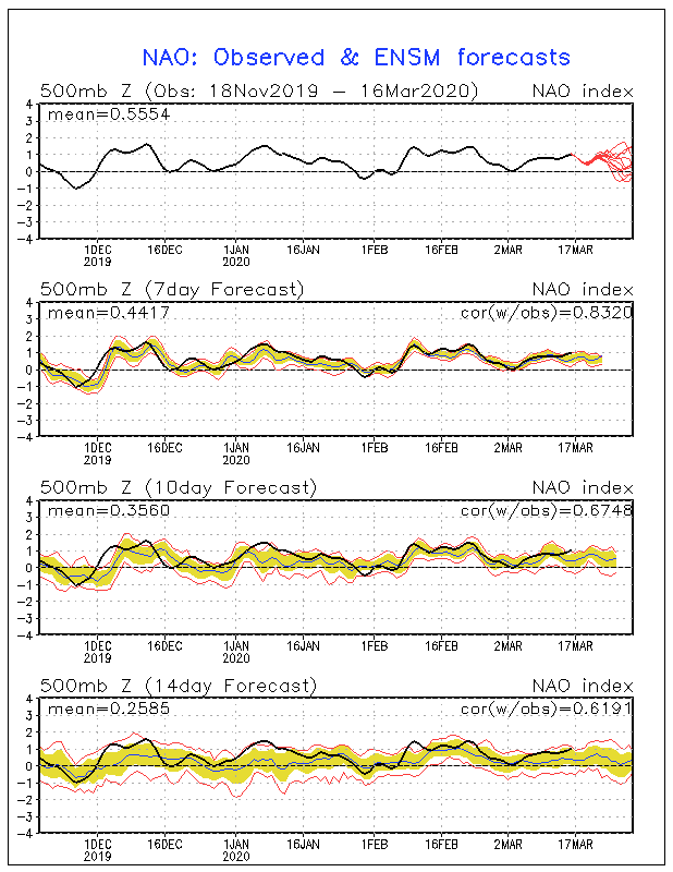
And now, of course, you want to know where to check the current NAO status. To do so, simply google NAO and NOAA, or click on this NOAA page. There you can follow the last months of the NAO in high resolution. There is also a forecast for the next 2 weeks.
We see: In fact, the NAO was mostly positive during the winter. The forecasts for the next 2 weeks are not consistent. Bad luck. But if all models show a sharp downward trend in winter, you urgently need to buy road salt.
If you understand the NAO, you will get along better in life and in the climate change labyrinth. Finally we allow ourselves the question:
Why can’t the DWD German Weather Service explain such contexts to us?

Source: NOAA
Stay healthy!


[…] über Europe’s Warm Winter Due To Natural Factors, Says Norwegian Center for Climate Research CICERO —… […]
All climate variations are natural.
Only Malthusian misanthropes believe otherwise as they have the outrageous belief that humans are not really natural beings. There is no evidence that shows what man does, and has done, is not driven by nature.